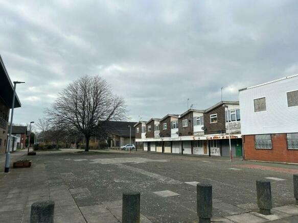
Sandbrook Road, Southport, Merseyside, PR8
- SIZE AVAILABLE
88,862 sq ft
8,256 sq m
- SECTOR
Convenience store for sale
- USE CLASSUse class orders: A1 Shops
A1
Key features
- Food store redevelopment opportunity
- Acting on behalf of Sefton Council
- Developable potential of 2.04 acres
- Adjacent busy arterial road
- Large potential customer base
Description
Sandbrook Way Neighbourhood Centre was designed and developed in the late 1960's as a mixed-use retail and residential development. A wholesale redevelopment is now envisaged as part of the local authority's intention to regenerate the location.
In total the area of the site is approximately 2.04 acres. The opportunity consists all of the public realm along Sandbrook Way, the cleared former PH site and the residential and retail parades that front Sandbrook Way onto Sandbrook Road. The redevelopment includes a proposed new vehicular access route on Sandbrook Way from Liverpool Road. No access is envisaged from Sandbrook Road.
A modern, bespoke Health Centre neighbours the site to the south. There is a mixture of private and social housing in the vicinity in addition to a church to the west.
TENURE
The main site is held in freehold ownership by Sefton MBC. Each of the current and former retail units and the individual flats are held on separate 99-year leases from 1967.
Sefton Council has approved an approach to acquire all the existing leasehold interests to bring it under one single ownership. The Council intends as part of the redevelopment to continue with the land assembly to bring the whole of the Centre to a single ownership and thereafter offer a suitable title to enable development. Further details to be provided.
PLANNING
The site is located within a primarily residential area. Policy HC3 of the Sefton Local Plan sets out that:
* New residential development will be permitted in Primarily Residential Areas shown on the
Policies Map where consistent with other Local Plan policies.
* Non-residential development will be permitted in Primarily Residential Areas provided that it
can be demonstrated that the proposal:
a) will not have an unacceptable impact on the living conditions of neighbouring properties, and
b) will otherwise not harm the character of the residential area, and
c) will not undermine objectives of the plan regarding housing delivery.
The above is intended as a guide only and all parties to satisfy their own enquiries with the local planning authority.
DEVELOPMENT OPTIONS
Whilst alternatives have been identified, the preferred option is a comprehensive redevelopment solution for the site based on a standalone food store with appropriate public realm and infrastructure together with other development as appropriate.
However, this use is dependent on the provisions of Local Plan Policies HC3 and ED2 being met.
Key to the development will be the provision of a new vehicular link through to Liverpool Road along the existing Sandbrook Way. There would be no vehicular access to the site from Sandbrook Road.
TERMS
Interest is sought to enter into a development agreement to regenerate and secure a new food based operator. Further details on request or negotiation.
Brochures
Sandbrook Road, Southport, Merseyside, PR8
NEAREST STATIONS
Distances are straight line measurements from the centre of the postcode- Ainsdale Station0.6 miles
- Hillside Station2.0 miles
- Freshfield Station2.4 miles
Notes
Disclaimer - Property reference Sandbrook. The information displayed about this property comprises a property advertisement. Rightmove.co.uk makes no warranty as to the accuracy or completeness of the advertisement or any linked or associated information, and Rightmove has no control over the content. This property advertisement does not constitute property particulars. The information is provided and maintained by Keppie Massie Limited, Liverpool. Please contact the selling agent or developer directly to obtain any information which may be available under the terms of The Energy Performance of Buildings (Certificates and Inspections) (England and Wales) Regulations 2007 or the Home Report if in relation to a residential property in Scotland.
Map data ©OpenStreetMap contributors.


