Cowbit, PE12 6AQ
- SIZE
Ask agent
- SECTOR
Residential development for sale
Description
LOCATION
** Total Area Approximately 2.6 Acres (1.05 Hectares) - Outline Planning Consent for 7 Units ( on 0.8 Acres - 0.32 Hectares ) - Very attractive location, close to the historical centre of the village and its amenities. - Only 4 Miles from nearby Spalding and 14 miles from Peterborough **
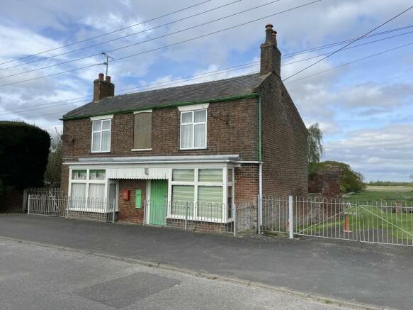
The property is located close to the historical centre of the village of Cowbit, lying only 3 miles south of Spalding and with easy access via the A16 or Barrier Bank. The property has for many years been owned by the Higham Family and historically it was the village Post Office, General Stores, Petrol Filling Station and a separate cobbler´s shop in the 1920´s and 1930´s. At present it comprises a detached 3 Bedroom house which would require very extensive refurbishment if it was to be retained, together with a semi-detached former cottage which will require demolition to facilitate the proposed new development.
The Land runs to the rear of the house with gardens, paddock and former farm/livestock buildings.
The offering of this property provides an opportunity to create an attractive and individually designed development of residential properties in a very convenient and attractive location. The property is available with the benefit of vacant possession and extends in total to about 2.6 Acres (1.05 Hectares) including the part having the benefit of Planning Consent plus the additional Paddock areas to the rear.
DESCRIPTION
A detached brick and slate-built house providing the following accommodation.
GROUND FLOOR (former Post Office/shop) 4m x 4.82m plus bay.
Living room 3.94m x 4.2m plus bay
Kitchen No 1 (left hand side) 3.13m x 3.14m
Rear Hall 3.13m x 1.54m
Door under staircase leading to basement cellar.
Original Kitchen No. 2 (right hand side) 3.12m x 2.99m with original Range.
Rear Entrance/Conservatory 1.35m x 3.70m
Staircase to first floor Landing.
FIRST FLOOR
Landing
Bedroom 1 (SW) - 3.94m x 4.85m
Bedroom 2 (NW) - 3.96m x 4.21m
Bedroom 3 (SE) - 3.16m x 3.91m
2nd Landing with Airing Cupboard off and leading to…
Bathroom with bath and wash handbasin - 1.72m x 1.54m
Separate WC with low level suite
OUTSIDE
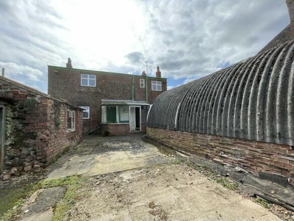
Range comprising former Wash House - 3.11m x 2.44m with copper and further Store to rear.
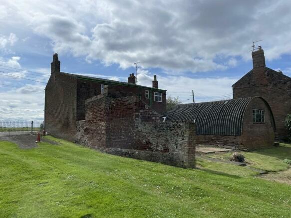
Nissen Shaped Building - 6.66m x 4.94m gross internal measurements.
Old timber and corrugated iron shed frame.
2 Small Poultry House
Grassed Gardens leading to paddock at rear plus a range of former livestock buildings.
Former semi-detached cottage - Please note that the roof of this has been removed and if it is to be demolished in due course, interested parties should make their own specific enquiries with the relevant authorities as to the necessary consents and to consider Party Wall Procedures, bearing in mind that it is presently built up to/attached to a neighbouring residential property and therefore will need careful consideration/liaison with that property owner well in advance of any action on site.
AREAS
The total area of the property extends to approximately 2.6 acres ( 1.05 Hectares)
Interested parties must carry out their own on-site survey to verify these areas. They are provided for general guidance purposes only and should not be relied upon.
Items available for forwarding to interested parties upon request from our Residential Development Land Department on
1. Original Planning Application.
2. Outline Planning Consent under reference H01-0517-22.
3. Copies of the Registered Titles.
4. Copies of the Registered Title Plans.
BOUNDARIES
The Vendors´ Agents have additional information with regard to what the vendors´ understanding is regarding ownership etc. for the relevant boundary features. Such information is available upon request.
SERVICES
Whilst not presently connected, the house was previously connected to mains electricity and water. Drainage is to a private system immediately to the rear of the house. There is no mains gas connected.
District & Planning: South Holland District Council
Priory Road, Spalding, Lincolnshire, PE11 2XE
CALL:
Water & Sewerage: Anglian Water Customer Services, PO Box 10642, Harlow, Essex, CM20 9HA
CALL:
County & Highways: Lincolnshire County Council, County Offices, Newland, Lincoln LN1 1YL
CALL:
Electricity: Western Power Distribution - New Supplies - Customer Application Team
Tollend Road, Tipton, DY4 0HH
Email:
CALL:
Internal Drainage Board: South Holland Internal Drainage Board, Marsh Reeves, Foxes Low Road, Holbeach, Spalding, PE12 7PA
VAT
The vendors have not elected to waive the exemption to tax (opt to tax) and therefore, VAT will not be chargeable in addition to the purchase price.
PLANNING
Outline Planning Consent was granted by South Holland District Council under Application Reference No: H01-0571-22 dated 28th October 2022. The present consent limits the development to not more than 7 dwellings. There are also a number of important conditions which interested parties should research as part of their enquiry process. A copy of the Outline Consent and the original Application can be forwarded upon request. The area of the property being the subject of the Outline Consent extends to about 0.8 Acres (0.32 Hectares).
It should be noted that the Outline Planning Consent obtained relates to part of the site - the rear paddocks were not included in that application/consent.
OTHER
BOUNDARY
It should be noted that the immediate left-hand boundary on viewing the site from the public highway does not quite align on the ground with that shown on the indicative outline planning consent plan. Interested parties should be aware of this as part of their enquiry process.
There is also a public sewer main running across the property which is shown (very approximately and for indicative purposes only) with a dotted brown line on the plan attached to these particulars. Interested parties should research details on these as part of their pre-offer process.
PETROL TANKS
There are some underground former petrol storage tanks just inside the front right-hand boundary. We are advised these petrol tanks were decommissioned by Shell Petroleum when they ceased supplying petrol to the property. The decommissioning was arranged and paid for by Shell. They were decommissioned by being pumped dry and the air space being filled with sand by contractors. We understand that the decommissioning work was undertaken during the early 1970's,
UPLIFT / CLAWBACK PROVISION
Notwithstanding that the present outline consent limits the development to 7No. units on part of the property, should the number of developed properties exceed 7No. in total on any part of the property now being offered for sale, this will be covered by an uplift/clawback provision to be inserted in the sales documentation reflecting that any increase in the numbers above 7No. will be subject to such provision for a period of 25 years and at the rate of 35% of the increase in value, consequent to the additional unit numbers being consented/built.
TENURE
The property has the benefit of Freehold tenure.
POSSESSION
It is offered with the benefit of vacant possession upon completion.
REGISTERED TITLES
The land is registered under LL378230 & LL378231 - Copies of the Registered Titles and the plans are available from the Selling Agent upon request.
RETENTION
It should be noted that the electric AGA in the kitchen, one of the poultry houses and the former Royal Mail Post Box in the front of the house, together with a concrete water trough will be retained by the vendors. These will be removed prior to completion.
ENERGY PERFORMANCE CERTIFICATE:
No Energy Performance Certificate (EPC) has been obtained as it is anticipated that the properties will be demolished as part of a redevelopment scheme.
OUTGOINGS:
Council Tax:
For 110 Barrier Bank, Cowbit, Spalding, Lincs, PE12 6AQ - Council Tax Band B
Land Drainage Rates:
These are presently paid annually to the South Holland Internal Drainage Board.
PARTICULARS CONTENT
We make every effort to produce accurate and reliable details but if there are any particular points you would like to discuss prior to making your inspection, please do not hesitate to contact our office. We suggest you contact our office in any case to check the availability of this property prior to travelling to the area. The particulars have been prepared and the photographs were re-taken in April 2024.
Ref: S11241
These particulars are issued subject to the property described not being sold, let, withdrawn, or otherwise disposed of. These particulars are believed to be correct, but their accuracy cannot be guaranteed, and they do not constitute an offer or a contract.
CONTACT
R. Longstaff & Co. LLP, 5 New Road, Spalding, Lincolnshire, PE11 1BS
T: - E: -
VIEWING
On-site viewing of the site is by prior appointment only. Interested parties must contact the Residential Development Land Department of Messrs R Longstaff & Co, LLP on Tel: or Email: to make the necessary prior appointment.
Note: ALL PARTIES ENTERING ANY PART OF THE PROPERTY DO SO ENTIRELY AT THEIR OWN RISK AND NEITHER THE VENDORS NOR THEIR AGENTS WILL ACCEPT ANY LIABILITY FOR DAMAGE TO PERSONS OR PROPERTY AS A RESULT OF BEING ON THE PROPERTY. PLEASE TAKE ALL APPROPRIATE PRECAUTIONS WHEN VISITING THE PROPERTY TO ENSURE YOUR OWN SAFETY.
Brochures
Cowbit, PE12 6AQ
NEAREST STATIONS
Distances are straight line measurements from the centre of the postcode- Spalding Station3.1 miles
Notes
Disclaimer - Property reference 101505014643. The information displayed about this property comprises a property advertisement. Rightmove.co.uk makes no warranty as to the accuracy or completeness of the advertisement or any linked or associated information, and Rightmove has no control over the content. This property advertisement does not constitute property particulars. The information is provided and maintained by Longstaff Chartered Surveyors, Spalding. Please contact the selling agent or developer directly to obtain any information which may be available under the terms of The Energy Performance of Buildings (Certificates and Inspections) (England and Wales) Regulations 2007 or the Home Report if in relation to a residential property in Scotland.
Map data ©OpenStreetMap contributors.


