Llangrove
- PROPERTY TYPE
Land
- SIZE
Ask agent
Description
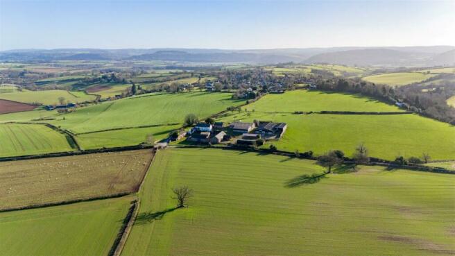
Situation - The development site is a former agricultural farmstead set in open countryside. The nearest village of Llangrove is situated approximately 0.5 miles away, within walking and cycling distance, which offers the following facilities: Primary School, Public House Community Hall, and Church. The site is served by three existing agricultural access points which connect with the adopted road to the north west and north of the site. Llangrove is served by bus routes connecting with surrounding villages as well as the city of Hereford.
Lot 1: Farmhouse, Outbuildings & Cider Barn -
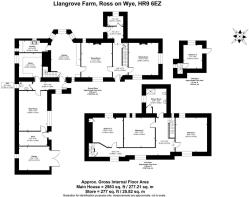
Farmhouse - Treduchan Farmhouse is a unique two-storey residence with extensive gardens and outbuildings. The farmhouse is rendered under a dual-pitched slate roof with partial UVPC double glazed windows. The circa 2983 sq.ft. property benefits from a range of period features such as flagstone floors, Victorian floor tiles, exposed beams, and fireplaces. The property needs refurbishment throughout.
Accommodation -
Kitchen - Quarry tile floor, base and eye level units, bay window, electric oven and Rayburn Royal stove, door to stairs.
Scullery - Quarry tile floor, sink drainage unit, base level units, timber shelving, cold slabs, and exposed beams.
Rear Entrance Hall - Quarry tile floor, leading to storeroom, WC, pantry.
Wc - Toilet, pedestal handwash basin, quarry tile floor.
Pantry - Flagstone floor, cold slabs, timber shelving.
Dining Room - Wooden floorboards, fireplace with wood burner, exposed beams, window seat, door to kitchen, door to main entrance hall.
Main Entrance Hall - Victorian tiles, paneled staircase, door to cellar, door to lounge, door to boiler room, rear door.
Boiler Room - Housing the oil-fired boiler.
Cellar - beneath the dining room
Sitting Room - Fireplace with stone hearth, brick surround and stone mantle, wooden floorboards, dual aspect windows.
Main Staircase - Leading to first floor.
Landing - Wooden floorboards, window seat.
Bathroom - Wooden floorboards, pedestal handwash basin, WC, shower cubicle.
Large Double Bedroom 1 - Situated up steps, wooden floorboards, fireplace, dual aspect.
Large Double Bedroom 2 - Wooden floorboards, fireplace, built in storage.
Large Double Bedroom 3 - Wooden floorboards, fireplace, radiator, airing cupboard with hot water tank.
Servants Staircase - Leading back down to the kitchen.
Attic Staircase - Leading to the attic space and fourth bedroom.
Smaller Double Bedroom 4 - Wooden floorboards, built into eaves.
Attic Space - Potential for storage.
Outside -
Outbuildings - There is a former washroom accessed from the rear hall that retains a former stone boiler with further access to an adjoining store room. An adjoining attached garage has potential as a workshop space.
Gardens - The farmhouse benefits from a large garden to the side and rear of the property.
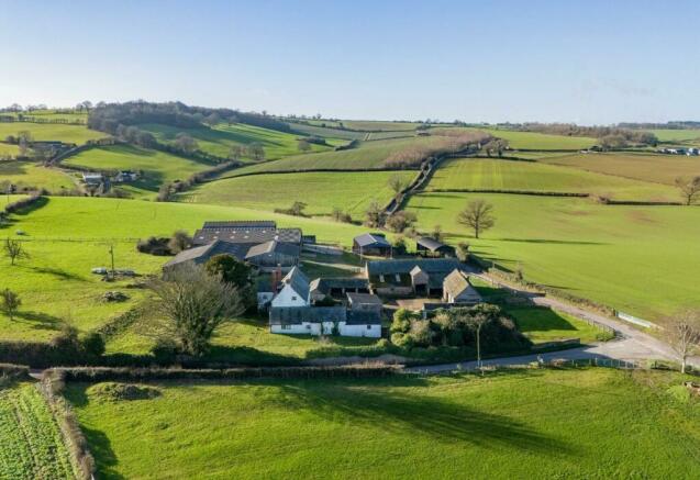
Courtyard - The farmhouse is situated in a traditional courtyard setting with the traditional farm buildings. The courtyard provides a large hard standing area for parking.
Council Tax - Council Tax Band: C
Epc - EPC Rating: G
Traditional Cider Barn - The traditional cider barn is predominantly of stone and timber frame construction, the barn has two storeys with external stone steps leading to the first floor. The Traditional Cider Barn (Plot No. 8) has the benefit of planning permission P221395/F for conversion to a 157 M² two-bedroom residential dwelling.
Lot 2: Three Barn Conversions And Four New Build -
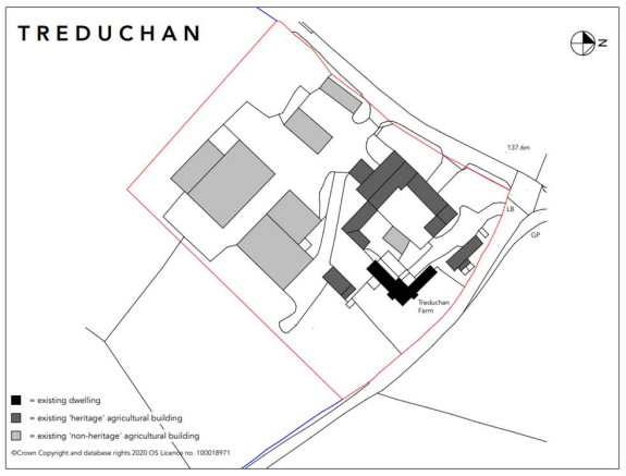
Farm Buildings - The existing farm buildings are a combination of traditional and modern steel portal frame buildings. The traditional buildings are located around an open yard next to the farmhouse with which they share access. The impressive barns are predominantly of stone and timber frame construction but are not listed.
The modern portal frame buildings are situated to their south with separate road access. These have mainly been used for keeping cattle and agricultural storage purposes.
The traditional buildings benefit from planning permission for conversion to residential dwellings
forming plots 5, 6, and 7 of the proposed development under planning permission P221395/F.
The modern portal frame buildings are to be demolished and replaced with four new build residential dwellings forming plots 1, 2, 3, and 4 of the proposed development under planning permission P221395/F.
Proposed Accommodation - The site of the former agricultural buildings has planning consent for residential development. The proposed scheme would create seven dwellings in total. Three dwellings would be created through the conversion of ‘historic’ buildings, and a further four dwellings through the removal of modern portal frame buildings to the southeast of the historic grouping and replacement with sympathetically designed new dwellings.
The proposed scheme is shown in more detail in the sales brochure.
Plot 1-4 Replacement Dwellings -
Each plot is designed to sit sympathetically alongside the nearby traditional buildings replicating their style and layout.
The new builds will be a mix of two storey dwellings with single storey garage and bike store.
External walls will be of timber cladding and rubble stone but in contrast with the traditional buildings will be of modern and sympathetic style.
The use of corrugated metal roofing will be subtly different to the slate and other roof covering on the traditional buildings but again provide a modern and sympathetic style.
Plots 5-7 The Traditional Buildings - Each plot retains the character and format of the existing bays all within the envelope of the traditional buildings.
Maximum opportunity has been taken to retain the fully vaulted roof elements, allowing existing roof trusses to be visible and providing the same sense of internal volume.
Few structural changes are necessary as most doors and windows use existing openings.
The present buildings will accommodate garaging, bike and bin stores thus avoiding the need for any future ad hoc buildings.
Access - The existing access serving Treduchan Farm house and units 5 - 7 is to be retained as existing. The access serving units 1 - 4 is proximate to the existing access serving the modern agricultural buildings, but relocated further south to improve emergent visibility. The access currently serving units 5/6 will be closed off. A new field gate access is to be provided south of the main red line site area so as to avoid conflict between agricultural and residential traffic.
Services - Mains water and electricity are understood to be available at the site. The farmhouse has private septic tank drainage. The site is not understood to be served by mains gas or sewerage. Accordingly, the developments drainage proposal includes for a non-mains drainage system and the scheme presents opportunities to incorporate renewable heating technologies.
Planning - The Local Planning Authority is Herefordshire Council. Planning Consent was granted on Wednesday 27th September 2023, a copy of the Decision Notice is contained within the available information pack.
The application that has been approved is detailed below:
P221395/F - Residential development of the site and associated works comprising the conversion of traditional agricultural building to four dwellings, and the replacement of modern agricultural buildings with four new- build dwellings.
Please see the proposed scheme drawings for further information. Parties may wish to discuss the scheme with Matt Tompkins of Tompkins Thomas Planning who has developed the scheme to date alongside Owen Hicks Architecture.
Permissive Path - The permissive path crosses the vendors retained land. On the 2nd February 2024, condition 14 attached to planning permission 221395 was discharged.
Ref: P240228/XA2: Prior to the first occupation of the dwellings hereby permitted, a scheme of the implementation, management and maintenance of the permissive path detailed on the approved plans shall be submitted to and approved in writing by the Local Planning Authority. The path shall be made available for use and thereafter managed in accordance with the approved details prior to the first occupation of the dwellings hereby permitted.
A copy of the agreed scheme and a location plan for the permissive path is contained within the available information pack.
Information Pack - An ‘Information Pack’ has been prepared that provides detailed information on planning, services, drawings and other reports. Access to the Information Pack can be provided upon request. Please contact Peter Kirby by email: p. or Tara Boulton
t.
Local Authority & Public Utilities - Herefordshire Council, Plough Lane, Hereford, HR4 0LE.
Welsh Water Dwr Cymru, Pentwyn Road, Nelson, Treharris, Mid Glamorgan, CF46 6LY.
National Grid, Vincent Carey Rd, Hereford, HR2 6LB.
Tenure - Freehold with vacant possession upon completion of sale.
Boundaries - The purchaser will be responsible for erecting and maintaining a pet and stockproof boundary around the site within three months of purchase.
Wayleaves, Easements & Rights Of Way - The property is sold subject to and with the benefit of all easements, quasi easements, wayleaves, and rights of way both declared and undeclared.
Site Plans - The plans included in the sale particulars are for identification purposes only and may have been reduced in scale to assist with printing.
Money Laundering - As a result of anti-money laundering legislation Prospective Purchasers will need to show proof of ID (Photo ID for example passport or driving licence and Residential ID for example current utility bill).
Agents Note - Any plans used in the preparation of these details may have been reduced in scale and any interested parties should check the Title Plan before proceeding to purchase.
Overage - There will be an overage clause should the number of dwellings on the site increase above nine.
Directions - From Monmouth take the A466 towards Hereford, after about four miles turn right at Welsh Newton towards Llangrove/Welsh Newton Common. The property is on the right hand side just prior to the right turn to Llangrove.
From Hereford take the A49 towards Ross on Wye, beyond Harewood End turn right onto the A4137 and after about three miles turn right to Llangarron. Pass through Llangarron towards Llangrove and after about 1.25 miles the property is on the corner to the turn to Llangrove.
HR9 6EZ What3Words: ///legend.armrests.club
Viewing - Strictly by appointment with the Agents.
Peter Kirby )
p.
Tara Boulton )
t.
Health & Safety Notice - Purchasers should take all necessary care when making an inspection including wearing suitable clothing. Viewings are taken solely at the risk of those who view and neither the Agents nor the owners of the property take responsibility for any injury however caused. You should not enter onto the first floor of Building 8 from the outside steps.
Important Notice - These particulars are set out as a guide only. They are intended to give a fair description of the property but may not be relied upon as a statement or representation of facts. These particulars are produced in good faith but are inevitably subjective and do not form part of any Contract. No persons within Sunderlands have any authority to make or give any representation or warranty whatsoever in relation to the property.
Brochures
FINAL Treduchan - Brochure V3.pdfBrochureLlangrove
NEAREST STATIONS
Distances are straight line measurements from the centre of the postcode- Lydney Station13.1 miles
Notes
Disclaimer - Property reference 33116213. The information displayed about this property comprises a property advertisement. Rightmove.co.uk makes no warranty as to the accuracy or completeness of the advertisement or any linked or associated information, and Rightmove has no control over the content. This property advertisement does not constitute property particulars. The information is provided and maintained by Sunderlands, Hereford. Please contact the selling agent or developer directly to obtain any information which may be available under the terms of The Energy Performance of Buildings (Certificates and Inspections) (England and Wales) Regulations 2007 or the Home Report if in relation to a residential property in Scotland.
Map data ©OpenStreetMap contributors.


