Scalford & Wycomb, Melton Mowbray
- PROPERTY TYPE
Land
- SIZE
16,552,800 sq ft
1,537,807 sq m
Key features
- 380 acres (or thereabouts) of prime agricultural land subject to tenancy
- Lot 1 - 338.63 acres (subject to Agricultural Holdings Act tenancy)
- Lot 2 - 42 acres (subject to Farm Business Tenancy)
- Lot 3 - 0.22 acres (subject to orchard agreement)
- Range of traditional buildings as well as modern buildings
Description
The majority of the land is believed to have been in the ownership of the Wyggestons Hospital Estate since 1519 and is thought to be one of the original farms that was purchased to support the Charity’s endeavours. It is offered to the market for the first time since it was acquired and offers the opportunity to purchase an historical part of the Estate.
Available as a whole or in 3 lots
Lot 1 – 338.63 acres (137.04 hectares) subject to an Agricultural Holdings Act tenancy
Lot 2 – 42 acres (17 hectares) subject to Farm Business Tenancy
Lot 3 – 0.22 acres (0.09 hectares) subject to an orchard agreement.
Location - The land is situated between the villages of Scalford and Wycomb in the Melton district of Leicestershire. The land benefits from various direct road access points around the villages and is situated approximately 4 miles north of the centre of Melton Mowbray.
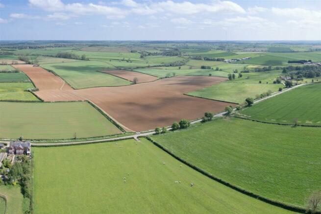
Description - The land, which extends to 380.85 acres (154.13 hectares) in total, is available as a whole or in up to 3 lots and is sold subject to an existing Agricultural Holdings (1986) Act tenancy (338.63 acres/137.04 hectares), an existing Farm Business Tenancy (42 acres/17 hectares) and an existing orchard agreement (0.22 acres). The land is predominantly arable, with some areas of pasture land, an area of woodland and a small area of amenity land/orchard.
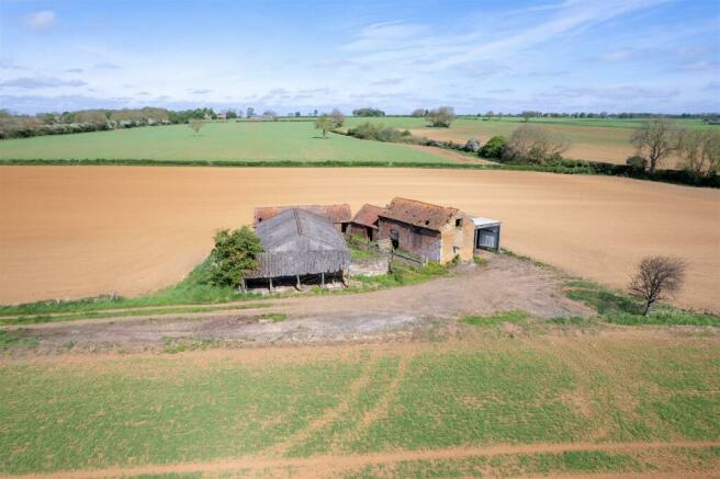
Towards the north of the block of land there is a range of traditional stone and red brick farm buildings, as well as a set of more modern farm buildings on the southern end of the holding.
The holding is offered for sale as a whole or in the following lots:
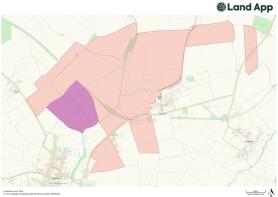
Lot 1 – 338.63 acres (137.04 hectares) subject to an Agricultural Holdings Act tenancy, as shown coloured red on the plan (for the avoidance of doubt, the area of woodland included in this lot in currently in hand and is sold with Vacant Possession).
Lot 2 – 42 acres (17 hectares) subject to Farm Business Tenancy, as shown coloured purple on the plan.
Lot 3 – 0.22 acres (0.09 hectares) subject to an orchard agreement, as shown coloured blue on the plan.
Farm Buildings - Within Lot 1, and included with the Agricultural Holdings (1986) Act tenancy agreement, are two sets of farm buildings.
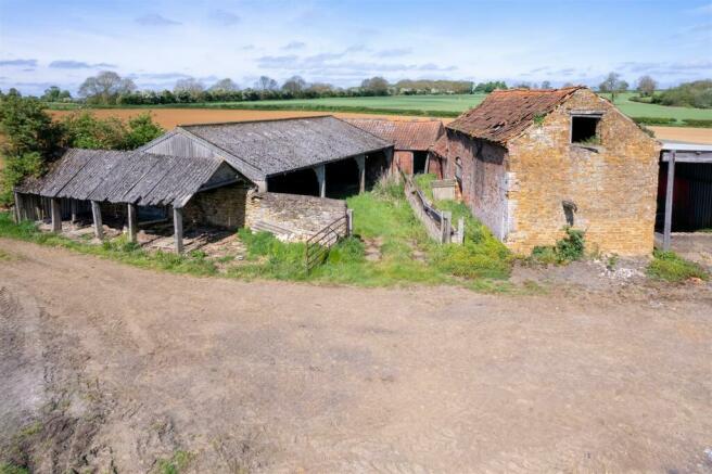
To the north of the holding is a range of traditional stone and red brick buildings set around a central grass yard area. This range comprises:
1 – An attractive, two storey stone barn under a pitched, tiled roof with an earth floor
2 – Open fronted timber pole barn with corrugated metal sheet sides
3 – Single storey, red brick stable/livestock house under a pitched roof with concrete floor
4 – Single storey, open fronted part stone, part red brick barn with earth floor under a pitched, tiled roof
5 – Semi modern concrete portal framed opened front barn under a pitched, fibre cement roof with stone walls enclosing rear and side elevation
6 – Timber framed, open sided lean to/log store under a pitched, fibre cement sheet roof
7 – Dilapidated timber shed
The second set of buildings is situated to the south of the holding on the field closest to Wycomb. This is a more modern set of buildings comprising the following:
M1 – 7 bay, steel portal framed, open fronted barn under a pitched, tiled roof with part concrete block walls with Yorkshire boarding above.
M2 – 7 bay, steel portal framed, open ended livestock house with part brick walls with Yorkshire boarding above and a concrete floor. Fitted with barriers with central feed passage.
A concrete yard extends along the north and western elevations of the buildings with an earth yard situated to the front (east) of the buildings.
Land Classification - According to the Agricultural Land Classification Map, the land is part Grade 2 (very good) and part Grade 3 (good to moderate).
Services - It is believed that mains water is connected to parts of the land but these connections have not been tested. No other services are thought to be connected.
Basic Payment Scheme - The land is registered for the Basic Payment Scheme but the entitlements sit with the agricultural tenant.
Tenure - The freehold interest in the land is offered for sale, subject to three prevailing tenancy agreements. The land is registered with the Land Registry and is held under Title Numbers LT383578, LT383484, LT383485, LT383486, LT243774 and LT390113.
For the avoidance of doubt, a small area of land is not registered with the Land Registry, and this can be identified by the Selling Agent on request.
The majority of the land, as shown coloured red on the plan and extending to circa 338 acres, is sold subject to a first succession Agricultural Holdings (1986) Act tenancy, which was succeeded to on 22nd January 1992.
42 acres, as shown coloured purple on the plan, is subject to an annual periodic Farm Business Tenancy agreement, with a start date of 25th March 2006. The tenancy was for an initial term of 7 years.
0.22 acres, as shown coloured blue on the plan, is subject to an orchard agreement dated 18th December 2020. 12 months notice can be served to obtain Vacant Possession of this area.
Further details and redacted copies of the tenancy agreements can be obtained from the Selling Agent on request.
Rights Of Way, Easement & Wayleaves - The land is sold subject to, and with the benefit of, all existing wayleaves, covenants, easements and right of way, whether expressly referred to in these particulars or not.
Sporting, Timber & Mineral Rights - These are included in the sale insofar as they are owned by the Vendor.
Nitrate Vulnerable Zone (Nvz) - It is understood that the land is situated with a Nitrate Vulnerable Zone.
Method Of Sale - The property is offered for sale via Private Treaty.
Viewings - The land may be viewed by prior appointment with the Selling Agent. Please contact us to arrange a viewing.
Local Authority - Melton Borough Council –
Development Uplift Clause - The land will be sold subject to a Development Uplift Clause. This clause will entitle the Vendor to 30% of any uplift in value arising from any development of the land (excluding development for agricultural or equestrian use) for a period of 10 years.
Value Added Tax (Vat) - In the event that any part of the holding is subject to VAT, this will be payable by the purchaser in addition to the purchase price.
Legal Costs - Each party to bear their own costs associated with the transaction.
Plan, Area & Description - The plan, areas and description are believed to be correct in every way, but no claim will be entertained by the Vendor or the Selling Agent in respect of any error, omissions or misdescriptions.
Further Information - Please contact the Selling Agent if you require any further information relating to the land:
Andrew Robinson (Director)
andrew.
Ashling Toolan (Associate Director)
ashling.
Brochures
Scalford & Wycomb, Melton MowbrayScalford & Wycomb, Melton Mowbray
NEAREST STATIONS
Distances are straight line measurements from the centre of the postcode- Melton Mowbray Station3.8 miles
Notes
Disclaimer - Property reference 33150417. The information displayed about this property comprises a property advertisement. Rightmove.co.uk makes no warranty as to the accuracy or completeness of the advertisement or any linked or associated information, and Rightmove has no control over the content. This property advertisement does not constitute property particulars. The information is provided and maintained by Andrew Granger, Leicester. Please contact the selling agent or developer directly to obtain any information which may be available under the terms of The Energy Performance of Buildings (Certificates and Inspections) (England and Wales) Regulations 2007 or the Home Report if in relation to a residential property in Scotland.
Map data ©OpenStreetMap contributors.
