Epping
- SIZE
Ask agent
- SECTOR
Farm land for sale
Key features
- 93.4 acres of arable land
- For sale by informal tender
- Located in North Weald, Epping
- 3 miles to M11
- 3 miles to Epping Underground Station
Description
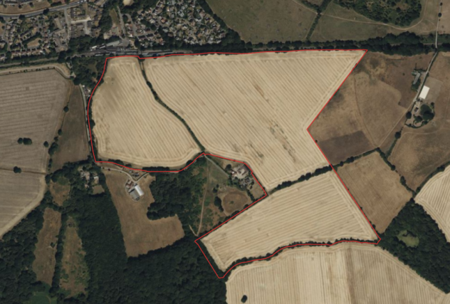
The land at Cold Hall Farm extends to approximately 93.4 acres consisting of three productive arable fields.
Location
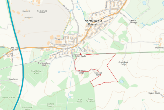
The land is located on the southern edge of North Weald, immediately south of the Epping Ongar railway line. By road, it is approximately 2 miles north east of the town of Epping and 3 miles west of Junction 7 of the M11.
Access to the land is from Kiln Road which joins the B181 road in North Weald, linking to the A414.
The nearest postcode is CM16 6AD.
The Land
The arable land extends to approximately 37.8 hectares (93.4 acres). It is Grade 3 as identified by the Agricultural Land Classification map for the Eastern Region. Soilscapes map describes the land as slowly permeable seasonally wet slightly acidic but base-rich loamy and clayey soils.
The cropping has been as follows:
Year | Cropping |
2021 | Winter Wheat |
2022 | Winter Wheat |
2023 | Winter Beans |
2024 | Winter Wheat |
Tenure
The land is offered for sale freehold. It is part of title EX902858.
Contract Farming Agreement
The arable land has been farmed through a contract farming agreement which commenced on 16th September 2014. This has continued from year to year. The agreement allows the termination by not less than 11 months' notice in writing by either party to the other, to expire on the 15th day of September in any contract year.
We are informed that the contractor would be happy to either vacate on completion or continue on terms to be agreed and therefore the land can be offered with vacant possession if required.
Tenant Right
Depending on the date of completion, the purchaser will be required to pay for the cost of all seeds, fertilisers and sprays applied plus the cost of cultivations which will be charged at the contractor rates in respect of any work carried out for the 2025 harvest. Enhancement will be charged at the rate of £10 per acre per month from the 1st December 2024 to completion.
Restrictive Covenants, Easements & RoW
The property is sold subject to any restrictive covenants, easements, quasi-easements, wayleaves or rights of way whether mentioned in these particulars or not.
It is understood that a gas pipe traverses the property.
There is a wayleave agreement with UK Power Networks for an overhead electricity line that traverses the property.
According to Essex PRoW interactive map, there are two bridleways that traverse the property (Stanford Rivers 2 and Stanford Rivers 57).
The land is situated in the Green Belt.
Whilst the majority of the land is elevated, a small part of the land is within Flood Zone 2.
Town & Country Planning
The land is located in the Epping Forest District.
Overage
The vendors preference would be to sell subject to overage along the following lines:
An overage term of 50 years with 30% of any uplift resulting from implementable planning uses other than horticulture, equestrian, forestry and agriculture. Base value for calculating the uplift will be the value at the date of establishing the overage but in a no scheme world. The overage will allow for multiple events however in that situation any overage already paid will be deducted. The Purchaser will be entitled to deduct reasonably attributable planning costs and other professional fees associated with obtaining the implementable planning consent prior to applying the percentage. The overage will be triggered by implementable planning consent but payable on implementation or sale.
Offers without overage or with alternative overage terms may be considered.
SFI
The land benefits from payments under a Sustainable Farming Incentive agreement. The agreement runs until 31/12/2026. A copy of the agreement is available on request.
Method of Sale
Completed tender forms to be submitted to Michael Hughes m. by midday on the Monday 30th September 2024.
Disclosure
Please note that a staff member of Whirledge & Nott is related to the vendor.
Notice
Whirledge & Nott does not have any authority to give representations or warranties in relation to the property. These particulars do not form part of any offer or contract. All descriptions, photographs and plans are for guidance only and should not be relied upon as statements or representations of fact. All measurements are approximate. No assumption should be made that the property has the necessary planning, building regulations or other consents. Whirledge & Nott has not carried out a survey. Purchasers must satisfy themselves by inspection or otherwise.
Viewing
Viewing of the property can take place from the public rights of way. Viewing of the property is entirely at the risk of the enquirer. Neither Whirledge & Nott nor the vendor accept any responsibility for any damage, injury or accident during viewing.
Brochures
Epping
NEAREST STATIONS
Distances are straight line measurements from the centre of the postcode- Epping Station2.3 miles
- Theydon Bois Station3.8 miles
- Debden Station5.5 miles
Notes
Disclaimer - Property reference 4649. The information displayed about this property comprises a property advertisement. Rightmove.co.uk makes no warranty as to the accuracy or completeness of the advertisement or any linked or associated information, and Rightmove has no control over the content. This property advertisement does not constitute property particulars. The information is provided and maintained by Whirledge and Nott, Commercial. Please contact the selling agent or developer directly to obtain any information which may be available under the terms of The Energy Performance of Buildings (Certificates and Inspections) (England and Wales) Regulations 2007 or the Home Report if in relation to a residential property in Scotland.
Map data ©OpenStreetMap contributors.


