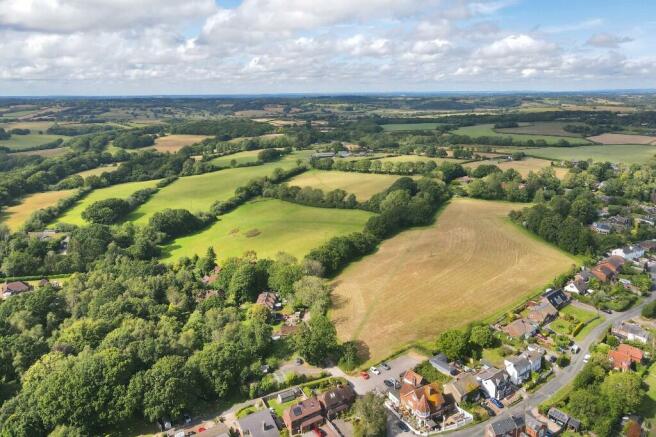
Maxfield Lane, TN35
- PROPERTY TYPE
Land
- SIZE
Ask agent
Description
DESCRIPTION
The Land at Little Maxfield is classified as Grade III on the Agricultural Land Classification Plan for England and Wales and extends in total to 25.84 acres. The land is a clay loam typical of this part of the Weald and has been tile drained. Access to the parcel is direct from Maxfield Lane via a gateway (Access 1 on the boundary plan) and there is an access gate from Butchers Lane (Access 2 on the boundary plan).
CURRENT FARMING
The land has historically formed part of a larger farm to the north. The vendors are reducing livestock numbers and reorganising their farming business. The land has been grazed in the past and cut for hay.
FENCING AND BOUNDARIES
The purchaser must satisfy themselves on the location of all boundaries from Land Registry documentation available.
Purchaser to fence the boundaries A - B and C - D on the plan, no later than 3 months from completion.
Brochures
Brochure 1Maxfield Lane, TN35
NEAREST STATIONS
Distances are straight line measurements from the centre of the postcode- Three Oaks Station0.3 miles
- Doleham Station1.0 miles
- Ore Station2.7 miles
Notes
Disclaimer - Property reference LandMaxfield. The information displayed about this property comprises a property advertisement. Rightmove.co.uk makes no warranty as to the accuracy or completeness of the advertisement or any linked or associated information, and Rightmove has no control over the content. This property advertisement does not constitute property particulars. The information is provided and maintained by BTF Partnership, Heathfield. Please contact the selling agent or developer directly to obtain any information which may be available under the terms of The Energy Performance of Buildings (Certificates and Inspections) (England and Wales) Regulations 2007 or the Home Report if in relation to a residential property in Scotland.
Map data ©OpenStreetMap contributors.


