Humber International Enterprise Park, Hull, Hull, HU12 8DS
- SIZE AVAILABLE
19,732,680 sq ft
1,833,228 sq m
- SECTOR
Light industrial facility to lease
Lease details
- Lease available date:
- Ask agent
Description
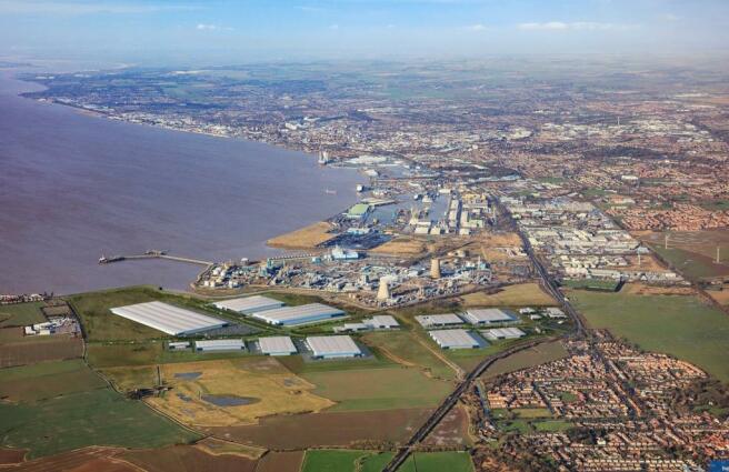
The site has an area of circa 183 hectares (453 acres) of development land with potential quayside access to the Port of Hull via a dedicated rail road link connecting the site into the respective UK networks.
+ Single unit occupancy of 25,000 – 2,000,000 sq ft
+ Site can be sub-divided to suit occupier requirements
+ Bespoke design and build opportunities
Location
The site lies adjacent to the city of Hull’s eastern boundary and occupies an area between the Saltend Chemicals Park at Saltend and the village of Paull. It is located close to the A1033, providing quick and easy access to the A63 and M62 motorway.
Planning
Outline planning permission has been granted for construction at the site across multiple use classes.
+ 394,839 sq m of employment floorspace B2, B8 and B1 floorspace
+ Up to 5,111sqm of flexible commercial floorspace, to include Classes A1-5, B1,C1, D1, D2
+ Associated landscaping and infrastructure
Brochures
Humber International Enterprise Park, Hull, Hull, HU12 8DS
NEAREST STATIONS
Distances are straight line measurements from the centre of the postcode- Hull Station9.6 miles
- New Holland Station9.1 miles
- Goxhill Station10.4 miles
Notes
Disclaimer - Property reference 53462-2. The information displayed about this property comprises a property advertisement. Rightmove.co.uk makes no warranty as to the accuracy or completeness of the advertisement or any linked or associated information, and Rightmove has no control over the content. This property advertisement does not constitute property particulars. The information is provided and maintained by Savills, Leeds Industrial. Please contact the selling agent or developer directly to obtain any information which may be available under the terms of The Energy Performance of Buildings (Certificates and Inspections) (England and Wales) Regulations 2007 or the Home Report if in relation to a residential property in Scotland.
Map data ©OpenStreetMap contributors.


