Wormbridge, Hereford

- PROPERTY TYPE
Barn Conversion
- SIZE
Ask agent
- TENUREDescribes how you own a property. There are different types of tenure - freehold, leasehold, and commonhold.Read more about tenure in our glossary page.
Freehold
Description
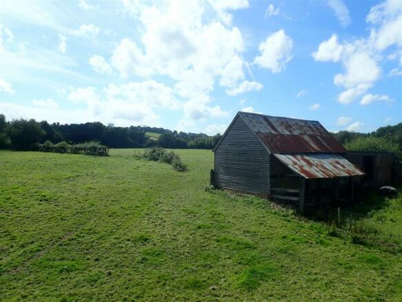
Top Barn is situated close to the villages of Wormbridge and Ewyas Harold. Ewyas Harold has a Pub, Doctors, Primary School and a Village Shop. The barn is set back off the main farm drive overlooking the surrounding land and rolling hills surrounding.
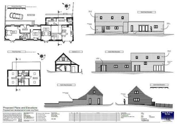
Top Barn - Barn With Class Q - Top Barn is a detached timber framed, part timber clad part brick barn with Class Q prior approval for change of use to a detached two storey 3 bedroomed residential dwelling set in 7.93 acres of land.
Proposed Accommodation - The proposed accommodation is over two storeys with the ground floor comprising open plan kitchen /dining room with separate utility room, boot room and shower room. The hallway leads to the sitting room and hallway to a separate office/snug and master bedroom with ensuite. The first floor comprises two further bedrooms and family bathroom.
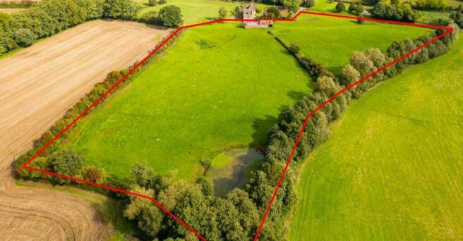
Land - The barn is set in a level pasture field overlooking the surrounding countryside. The land extends in total to 7.93 acres with small natural pond in the southwestern corner.
Planning Consent - Planning consent for the Class Q Prior Approval can be found using the reference number P233043/PA4.
The access road planning has been submitted as per the plan on the page opposite using reference P240377/F.
Planning documents and scaled plans are available via the Herefordshire Council Website.
Planning documents and scaled plans are available via the Herefordshire Council Website.
Local Authority & Public Utilities - Herefordshire Council
Welsh Water Dwr Cymru
National Grid
Sporting & Timber Rights - All standing timber or any sporting rights, if owned, are included in the sale.
Boundaries - The purchaser will be required to erect a stock-proof fence along the boundary marked A-B-C and D-E on the plan and as per the posts onsite within 3 months of completion.
The purchaser of Lot 4 will be required to erect a stock-proof fence along the boundary marked D-E-F-G on the plan within 3 months of completion. The purchaser of Lot 5 will be required to install a new access gateway into Lot 5
Services - No services are currently connected. The Vendor is in the process of creating a new separate mains water supply to the building.
Electric supplies are nearby. Necessary rights have been reserved over the adjoining properties.
Tenure - Freehold with vacant possession.
Poultry Building Restrictive Covenant - The poultry buildings to the north of are subject to a restrictive covenant preventing the use for pigs or poultry.
Council Tax - Lower Jury Farmhouse – F
Lower Jury Annex – A
Jury Bungalow – D
Wayleaves, Easements & Rights Of Way - The property is sold subject to and with the benefit of all easements, quasi easements, wayleaves, and rights of way both declared and undeclared.
Viewings - Viewing appointments must be booked in advance, please contact Katie Bufton, Peter Kirby or Tara Boulton on to arrange.
Access - The property will benefit from a right of way over the farm access track subject to a maintenance contribution according to user.
Site Plans - The plans included in the sale particulars are for identification purposes only and may have been reduced in scale to assist with printing.
Money Laundering - As a result of anti-laundering legislation all persons intending to bid must provide Proof of Identification (ID (Photo ID for example passport or driving licence and Residential ID for example current utility bill).
Directions - From Hereford take the A49 south and then turn onto the A465 towards Belmont. Continue along the A465 for approximately 5 miles then at the shell garage turn right on to the B4348 towards Peterchurch. Continue for approximately 1.4 miles then turn left towards Allensmore. Continue along the road for approximately 1.8 miles until you reach a T junction turn left here. Continue along the road for approximately 0.7 of a mile then turn right continue along for 0.4 of a mile and the property will
be on your right.
From Hay-on-Wye take the B4348 and continue along for approximately 12.9 miles then turn right towards Kerry Gate. Continue along for approx. 2 miles then there will be a T junction turn right here. Continue along for approximately 0.6 of a mile then turn right continue along for 0.4 of a mile and the property will be on your right.
What3words - renewals.locker.tulip
Health & Safety Notice - Prospective Purchasers should take all necessary care when making an inspection. Viewings are taken solely at the risk of those who view and neither the Agents nor the owners of the property take responsibility for any injury however caused.
Agents Note - Any plans used in the preparation of these details may have been reduced in scale and any interested parties should check the Title Plan before proceeding to purchase.
Important Notice - These particulars are set out as a guide only. They are intended to give a fair description of the property but may not be relied upon as a statement or representation of facts. These particulars are produced in good faith but are inevitably subjective and do not form part of any Contract. No persons within Sunderlands have any authority to make or give any representation.
Brochures
Top Barn Brochure 2024.pdfBrochure- COUNCIL TAXA payment made to your local authority in order to pay for local services like schools, libraries, and refuse collection. The amount you pay depends on the value of the property.Read more about council Tax in our glossary page.
- Exempt
- PARKINGDetails of how and where vehicles can be parked, and any associated costs.Read more about parking in our glossary page.
- Yes
- GARDENA property has access to an outdoor space, which could be private or shared.
- Ask agent
- ACCESSIBILITYHow a property has been adapted to meet the needs of vulnerable or disabled individuals.Read more about accessibility in our glossary page.
- Ask agent
Energy performance certificate - ask agent
Wormbridge, Hereford
Add your favourite places to see how long it takes you to get there.
__mins driving to your place
Your mortgage
Notes
Staying secure when looking for property
Ensure you're up to date with our latest advice on how to avoid fraud or scams when looking for property online.
Visit our security centre to find out moreDisclaimer - Property reference 32897098. The information displayed about this property comprises a property advertisement. Rightmove.co.uk makes no warranty as to the accuracy or completeness of the advertisement or any linked or associated information, and Rightmove has no control over the content. This property advertisement does not constitute property particulars. The information is provided and maintained by Sunderlands, Hereford. Please contact the selling agent or developer directly to obtain any information which may be available under the terms of The Energy Performance of Buildings (Certificates and Inspections) (England and Wales) Regulations 2007 or the Home Report if in relation to a residential property in Scotland.
*This is the average speed from the provider with the fastest broadband package available at this postcode. The average speed displayed is based on the download speeds of at least 50% of customers at peak time (8pm to 10pm). Fibre/cable services at the postcode are subject to availability and may differ between properties within a postcode. Speeds can be affected by a range of technical and environmental factors. The speed at the property may be lower than that listed above. You can check the estimated speed and confirm availability to a property prior to purchasing on the broadband provider's website. Providers may increase charges. The information is provided and maintained by Decision Technologies Limited. **This is indicative only and based on a 2-person household with multiple devices and simultaneous usage. Broadband performance is affected by multiple factors including number of occupants and devices, simultaneous usage, router range etc. For more information speak to your broadband provider.
Map data ©OpenStreetMap contributors.


