Higher Ebsworthy House, Bridestowe

- PROPERTY TYPE
Farm House
- BEDROOMS
5
- BATHROOMS
4
- SIZE
3,297 sq ft
306 sq m
- TENUREDescribes how you own a property. There are different types of tenure - freehold, leasehold, and commonhold.Read more about tenure in our glossary page.
Freehold
Key features
- Former Farmhouse
- No onward chain
- Approximately 4 acres (1.62 hectares) of productive permanent pasture land
- Range of outbuildings (extending to 4,833 square feet / 449 sq metres) with potential for change of use (STP)
- Further land available by separate negotiation
- Secluded rural location
- Shebbear College - about 14 miles north
- For sale by Private Treaty
Description
A30 Dual Carriageway - 3 miles
Bridestowe - 1.5 miles
Tavistock - 12 miles
Okehampton - 6 miles
DIRECTIONS
Proceed south-west on the A30 towards Launceston and take the A386 exit signposted ‘Sourton Cross’ towards Tavistock/Plymouth/Bideford/Holsworthy. At the end of the slip road turn right onto A386 then after approximately 50 yards turn left onto towards Bridestowe. Proceed along this road, after approximately 3 miles turn right onto Meadow View. Proceed for approximately 0.7 miles then turn right at Way Crossroads signposted ‘Week’. After approximately 0.5 miles turn left and proceed to Higher Ebsworthy House.
What3Words Location : decades.newspaper.rental
SITUATION
Higher Ebsworthy House is situated on the outskirts of the village of Bridestowe situated between Okehampton and Tavistock. The village is home to a sought-after primary school, village store and methodist church. The private school of Shebbear being only 14 miles to the north of the property.
Higher Ebsworthy House is located within easy access of Dartmoor National Park in the area of West Devon. The property falls outside of an area designated as a National Landscape (formerly known as Area of Outstanding Natural Beauty).
The nearest town of Okehampton is about 6 miles to the east. The A30 dual carriageway expressway, connecting to the M5 motorway and national road network, in close proximity approximately 3 miles away accessed via Sourton Cross junction, providing excellent transport links. The nearest city of Plymouth is about 25 miles to the west, Exeter being about 32 miles to the east.
DESCRIPTION
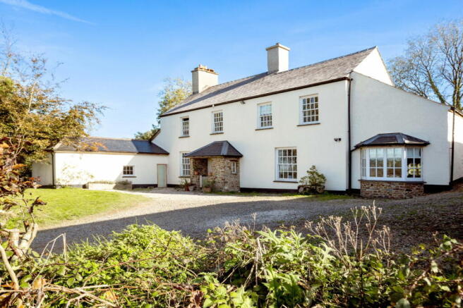
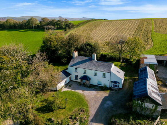
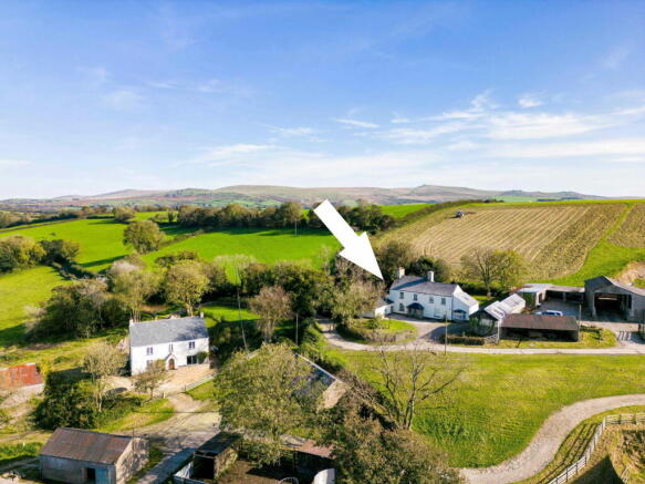
Higher Ebsworthy House comprises a detached farmhouse, range of stone and modern farm buildings and approximately 5.09 acres (2.06 hectares) in all, the full extent of which is approximately shaded in blue on the site plan below.
Access to Higher Ebsworthy House is by means of a right of way over the private driveway that leads to Lower Ebsworthy House (which is also being offered for sale).
The owner of Higher Ebsworthy House will have a right of way for all purposes at all times to access their own property and land. The area constituting the Right of Way for Higher Ebsworthy is shaded approximately in red on the site plan below.
Higher Ebsworthy Farmhouse
Not of Listed status, Higher Ebsworthy farmhouse is predominantly of traditional stone construction under a slate roof. The total approximate gross internal floor area of Higher Ebsworthy Farmhouse extends to 3,297 square feet (306.29 square metres).
The accommodation can be summarised as follows :-
Ground Floor
Open plan kitchen/breakfast room with external door to garden, dining room, snug, further sitting room, bedroom/office, utility room, boot room and two WC’s.
First Floor
Three double bedrooms, one of which with an en-suite, further single bedroom and two family bathrooms.
SERVICES
Separate mains metered electric supply, shared bore hole water supply (will require management plan), oil fired central heating and private septic tank drainage (not up to industry standard).
Note High speed fibre broadband will be installed by completion of Higher Ebsworthy House.
Stone and Modern Farm Buildings
The range of outbuildings extend to a total of some 4,833 square feet (449 square meters) in all. Constructed of a combination of solid stone walls, concrete pillars and timber side cladding under a mix of corrugated roof panels. Brief descriptions of the outbuildings are as follows:-
1. Atcost Barn - concrete pillars, timber side cladding– approx. 13m x 13m (1,819 square feet/ 169 square metres).
2. Double garage – approx. 6.5m x 7.5m (527 square feet / 49 square metres).
3. Quadbike store – approx. 16.5m x 4.5m (796 square feet/ 74 square metres).
4. Stables and stores – approx. 18m x 4m (775 square feet/ 72 square metres).
5. Rex’s Barn – approx. 17m x 5m (914 square feet/ 85 square meters).
The Lands
The land is situated directly east of Higher Ebsworthy House and consists of SX5090 5234 extending to some 4 acres (1.62 hectares).
The land offers a combination of predominantly gentle north facing slopes and has in the past been used for livestock grazing and mowing purposes due to its gentle gradient and benefits from the same shared bore hole water supply.
The land has been known for growing high levels of grass forage in the past years but would be suitable for a range of uses to include recreation/amenity/ livestock grazing purposes (subject to obtaining the necessary planning consents).
There is a further 10.06 acres (4.07 hectares) available by separate negotiation (SX5090 7443). This field parcel directly adjoins the land included in the sale of Higher Ebsworthy House and allows prospective purchases the opportunity to obtain further land if required. This field parcel is outlined in green on the below site plan.
Note Lower Ebsworthy House is also being offered for sale. The remainder of Ebsworthy Town Farm is being retained by the seller who has a hay & straw haulage business. More land and buildings available by separate negotiation.
The seller will undertake to erect a fence between what is being sold and the retained land (Ebsworthy Town Farm) to form a boundary, within 8 weeks following legal completion.
PUBLIC FOOTPATHS
There are no public footpaths across the property as far as known.
TENURE
The property is held on a freehold basis with vacant possession being available on legal completion.
SPORTING AND MINERAL RIGHTS
All sporting and mineral rights are included in the sale, as far as known.
ENVIRONMENTAL STEWARDSHIP SCHEME AGREEMENTS
The land of Higher Ebsworthy House is also entered into a Sustainable Farming Incentive Agreement (consisting of Herbal Leys) which ends on 31/05/2027.
LOCAL AUTHORITY & COUNCIL TAX
West Devon Borough Council, Killworthy Park, Drake Road, Tavistock, Devon, PL19 0BZ. Higher Ebsworthy Farmhouse falls within Council Tax Band D and the amount payable for 2024/25 is £2,387.99.
GUIDE PRICE
£595,000
METHOD OF SALE
Higher Ebsworthy House is offered for sale by Private Treaty.
VIEWINGS
Strictly by appointment on set viewing days with the Sole Selling Agents, Luscombe Maye of 62 Fore Street, Kingsbridge, TQ7 1PP. Telephone for details.
HEALTH & SAFETY
Any prospective purchasers of whom would like to view the land do so at their own risk. The vendors nor their selling agent accept any responsibility in any incident or accident that may happen.
AGENTS NOTE
Whilst every care has been taken to prepare these sales particulars, they are for guidance purposes only. All measurements are approximate are for general guidance purposes only and whilst every care has been taken to ensure their accuracy, they should not be relied upon and potential buyers are advised to recheck the measurements.
Brochures
Brochure 1- COUNCIL TAXA payment made to your local authority in order to pay for local services like schools, libraries, and refuse collection. The amount you pay depends on the value of the property.Read more about council Tax in our glossary page.
- Ask agent
- PARKINGDetails of how and where vehicles can be parked, and any associated costs.Read more about parking in our glossary page.
- Yes
- GARDENA property has access to an outdoor space, which could be private or shared.
- Yes
- ACCESSIBILITYHow a property has been adapted to meet the needs of vulnerable or disabled individuals.Read more about accessibility in our glossary page.
- Ask agent
Higher Ebsworthy House, Bridestowe
Add your favourite places to see how long it takes you to get there.
__mins driving to your place
Well known for handling the sale of farms, land, woodland and smallholdings Luscombe Maye has unrivalled experience in marketing this type of property in the West Country.
Our intimate knowledge of the area and understanding this type of property helps us achieve the maximum interest and therefore most importantly the maximum price for the asset.
We offer a no-obligation pre market appraisal and valuation service for the asset you are considering selling. As part of this service we would provide our marketing recommendations as to the method of sale, timing and marketing strategy that we would undertake on your behalf.
Your mortgage
Notes
Staying secure when looking for property
Ensure you're up to date with our latest advice on how to avoid fraud or scams when looking for property online.
Visit our security centre to find out moreDisclaimer - Property reference S1102418. The information displayed about this property comprises a property advertisement. Rightmove.co.uk makes no warranty as to the accuracy or completeness of the advertisement or any linked or associated information, and Rightmove has no control over the content. This property advertisement does not constitute property particulars. The information is provided and maintained by Luscombe Maye Farms & Land, Kingsbridge. Please contact the selling agent or developer directly to obtain any information which may be available under the terms of The Energy Performance of Buildings (Certificates and Inspections) (England and Wales) Regulations 2007 or the Home Report if in relation to a residential property in Scotland.
*This is the average speed from the provider with the fastest broadband package available at this postcode. The average speed displayed is based on the download speeds of at least 50% of customers at peak time (8pm to 10pm). Fibre/cable services at the postcode are subject to availability and may differ between properties within a postcode. Speeds can be affected by a range of technical and environmental factors. The speed at the property may be lower than that listed above. You can check the estimated speed and confirm availability to a property prior to purchasing on the broadband provider's website. Providers may increase charges. The information is provided and maintained by Decision Technologies Limited. **This is indicative only and based on a 2-person household with multiple devices and simultaneous usage. Broadband performance is affected by multiple factors including number of occupants and devices, simultaneous usage, router range etc. For more information speak to your broadband provider.
Map data ©OpenStreetMap contributors.


