Horley Road RH1
Letting details
- Let available date:
- Now
- Deposit:
- £1,442A deposit provides security for a landlord against damage, or unpaid rent by a tenant.Read more about deposit in our glossary page.
- Min. Tenancy:
- Ask agent How long the landlord offers to let the property for.Read more about tenancy length in our glossary page.
- Let type:
- Long term
- Furnish type:
- Part furnished
- Council Tax:
- Ask agent
- PROPERTY TYPE
Flat
- BEDROOMS
1
- BATHROOMS
1
- SIZE
Ask agent
Key features
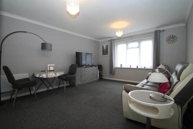
- NEWLY REFURBISHED THROUGHOUT
- NEW KITCHEN
- NEW BATHROOM
- NEW WATER HEATING SYSTEM
- NEW ECONOMICAL ELECTRIC HEATING
- LARGE STORAGE CUPBOARDS IN THE FRONT ROOM
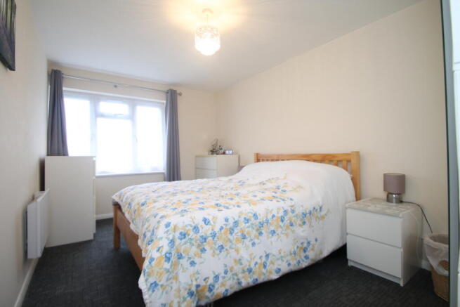
- TRIPLE WARDROBE AND SINGLE WARDROBE WITH MIRROR
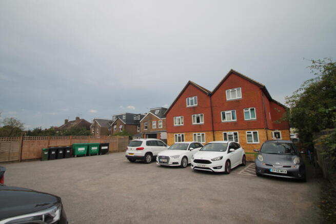
- ALLOCATED PARKING SPACE
- COMMUNAL GARDEN
- PART FURNISHED
Description
Large newly refurbished ground floor purpose built flat offered to the market part furnished, situated on the south side of Redhill with a short walking distance to East Surrey Hospital, and well served by three train stations at Salfords, Earlswood and Redhill. Spacious entrance hall, bright living room with huge storage cupboards brand new modern fitted kitchen, double bedroom, brand new bathroom Outside communal garden and an allocated parking space. . Council tax band C
Earlswood is a suburb of Redhill in Surrey, England, which lies on the A23 between Redhill (in the direction of London) and Horley (next to Gatwick Airport). Earlswood Common is a local nature reserve that separates the suburb from the southern outskirts of Reigate and has two lakes and picnic areas. Earlswood station is on the Brighton Main Line. To the east of the line are Royal Earlswood Park, the East Surrey Hospital and Whitebushes.
Earlswood
An area of predominantly Victorian housing, much of it terraced and semi-detached, immediately south of Redhill town centre bordered to the north by Hooley lane, to the west by the A23 Brighton Road, to the south by the Royal Earlswood Park housing development and to the east by fields. Redhill Brook runs north-south through the middle of Earlswood but is not visible in most of it. Two train lines run through Earlswood. The Redhill and Quarry Lines, both part of the Brighton Line, merge just north of Earlswood and run through Earlswood Station although there is no Quarry Line Platform. The Redhill to Tonbridge line passes through north Earlswood in between Redhill and Nutfield stations.
There are a nursery, primary and junior school over two sites in north Earlswood combined under the umbrella of the Earlswood Schools Federation. The schools are very popular and, along with the plentiful green space and good transport links, have attracted many young families to the area.
There are a few places of religious worship in Earlswood. There is St John's church on St Johns Road, opposite Earlswood, and there is also a Mosque on Earlswood Road, the Redhill Jamia Mosque Al-Mustafa. This is one of 3 mosques in the Redhill area, along with Masjid Al Yaqeen on Warwick Road, Redhill, and Masjid ul Emaan on Frenches Road near Watercolour and Merstham.
South Earlswood
One sub-area of Earlswood, South Earlswood is a separate neighbourhood containing approximately half of the housing, which constitutes the main land use in Earlswood.[7][8] Separating it from the north are Earlswood Common and the Greensand Way, which follows the Greensand Ridge from Haslemere to Kent. Immediately adjoining South Earlswood is the village or neighbourhood of Whitebushes, which is contiguous therefore, apart from councillors, is difficult to separate artificially.[9]
Whitebushes
A mixed housing estate built in the 1970s and early 1980s, surrounded by pre-existing farmland, South Earlswood and the railway line. East Surrey Hospital opened in 1979 to its north. A small portion of farmland remains common land where (traditionally) gypsy horses, used for riding lessons and transport, have grazed since the 1950s.
The area has been occupied since medieval times and probably before that, as evidenced by archaeological finds nearby of an axe[10] and flint flakes.[11] The surrounding farms date back to the 13th and 14th centuries, notably Hazelhurst Farm from 1203 and Dean Farm from 1316.[12] There is evidence of a medieval farmstead in Woodlands Field, off Green Lane. This consists mainly of soil marks in a square of about 350m and an adjoining L-shaped mark. The pottery has been dated to 1250–1350.[13]
In the 19th century a number of brick works sprung up in the area. The Reigate Isolation Hospital was established in 1884 and later renamed to the Reigate Rural District Infectious Diseases Hospital.[14] In 1900 a second establishment, the Reigate Borough Isolation Hospital, was opened. Around 1927 the two establishments were combined into a single Isolation Hospital run by the Reigate Joint Hospital Board as part of the Redhill County Hospital.[15] In 1960 the site was acquired by University College Hospital and renamed Jordan's Hospital[16] for the treatment of Tropical Diseases, especially leprosy. The site was sold for development in 1970 and the estate between Green Lane and the railway, including Jordans Close, was built.
The Brighton Main Line passes the west of Whitebushes and was opened in 1841. An ancient trackway[17] along what is now Green Lane, The Brow and the western leg of Bushfield Drive, links Whitebushes to Earlswood station to the north and Salfords station to the south. Somewhat circuitous routes under the railway link to the parking areas by these stations for those unwilling to walk. Council Tax Band: Holding Deposit: £288.46
- COUNCIL TAXA payment made to your local authority in order to pay for local services like schools, libraries, and refuse collection. The amount you pay depends on the value of the property.Read more about council Tax in our glossary page.
- Ask agent
- PARKINGDetails of how and where vehicles can be parked, and any associated costs.Read more about parking in our glossary page.
- Yes
- GARDENA property has access to an outdoor space, which could be private or shared.
- Ask agent
- ACCESSIBILITYHow a property has been adapted to meet the needs of vulnerable or disabled individuals.Read more about accessibility in our glossary page.
- Ask agent
Horley Road RH1

Add an important place to see how long it'd take to get there from our property listings.
__mins driving to your place

Notes
Staying secure when looking for property
Ensure you're up to date with our latest advice on how to avoid fraud or scams when looking for property online.
Visit our security centre to find out moreDisclaimer - Property reference 000796979. The information displayed about this property comprises a property advertisement. Rightmove.co.uk makes no warranty as to the accuracy or completeness of the advertisement or any linked or associated information, and Rightmove has no control over the content. This property advertisement does not constitute property particulars. The information is provided and maintained by Gascoigne Pees, Sutton. Please contact the selling agent or developer directly to obtain any information which may be available under the terms of The Energy Performance of Buildings (Certificates and Inspections) (England and Wales) Regulations 2007 or the Home Report if in relation to a residential property in Scotland.
*This is the average speed from the provider with the fastest broadband package available at this postcode. The average speed displayed is based on the download speeds of at least 50% of customers at peak time (8pm to 10pm). Fibre/cable services at the postcode are subject to availability and may differ between properties within a postcode. Speeds can be affected by a range of technical and environmental factors. The speed at the property may be lower than that listed above. You can check the estimated speed and confirm availability to a property prior to purchasing on the broadband provider's website. Providers may increase charges. The information is provided and maintained by Decision Technologies Limited. **This is indicative only and based on a 2-person household with multiple devices and simultaneous usage. Broadband performance is affected by multiple factors including number of occupants and devices, simultaneous usage, router range etc. For more information speak to your broadband provider.
Map data ©OpenStreetMap contributors.