Wadhurst, East Sussex
- PROPERTY TYPE
Land
- SIZE
1,219,680 sq ft
113,312 sq m
Key features
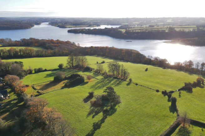
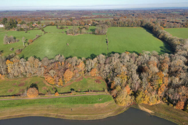
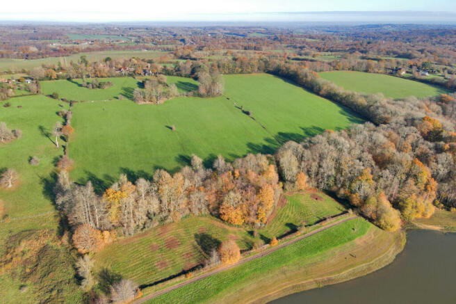
- A fine block of pastureland with wooded shaws
- Extending to approx 27.62 acres
- Stunning views over Bewl Water
- Some ancient woodland
- Grade 3 land
- Lot 2 only
Description
SITUATION
The land abuts the northern side of the western spur of Bewl Water 3 miles east of Wadhurst in East Sussex. Hawkhurst to the east is 8 miles and the A21 close by leads up to Tunbridge Wells 7 miles, Sevenoaks 19 miles and the M25/M26 junction just beyond.
DESCRIPTION
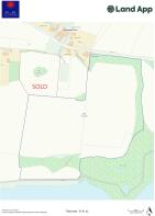
This fine block of pastureland standing above and then falling down to the boundary fence of Bewl Water is offered in two lots:
Lot 1 – 4.29 acres (1.73 ha) A useful paddock with an attractive copse in the middle.
Lot 2 – 27.62 acres (11.18 ha) A solid block of pastureland running down to the reservoir and having a shelter belt shaw of Sycamore, Oak and Pine along its northern and eastern boundary. A further shaw, classed as an ancient woodland, along the southern boundary has Beech, Oak and Chestnut cover and a track leading through to a naturally rewilded area and paddock directly adjoining the reservoir.
The land is all Grade 3.
In all about 31.91 acres (12.91 ha).
VIEWING
Strictly by confirmed appointment only with the sole agents RH & RW Clutton – /305825.
HEALTH & SAFETY
Whilst there are no immediate known risks, care must be taken when walking round. No dogs may be taken onto the ground.
TENURE & POSSESSION
The property is offered freehold and is currently let on a grazing licence until March 2023.
RIGHTS OF WAY & WAYLEAVES
The property is sold subject to and with the benefit of all existing rights of way whether public or private, including rights of way, drainage, water and electricity supplies, covenants, restrictions and obligations and all wayleaves whether referred to or not.
A footpath adjoins the northern boundary and exits at the main access point to the land.
Lot 1 will be granted a right of access into the ground at the north-east corner if sold separately.
Lot 2 has a separate access off the lane in the north-west corner.
SERVICES (Not tested and therefore not warrantied)
A metered mains water trough supply is laid onto the land. The vendor may wish to retain a submetered supply to adjoining ground.
TOWN & COUNTRY PLANNING
The property (not withstanding any description contained in these particulars) is sold subject to any existing Town & Country Planning legislation and to any development plan, resolution or notice which may be in force and also subject to any statutory provisions or by-laws without any obligation on the part of the Vendors or his Agents to specify them.
There are no current relevant issues affecting the land which lies within the High Weald AONB.
BPS/GRANT SCHEMES
Such entitlements as are held by the vendor and attached to the land will be transferred proportionally on completion. The land for the previous 30 years until recently has been organic and registered with the Soil Association. (A previous CSS agreement expired in 2020 and has not been renewed).
PLAN
The plan and stated acreages in these details are for identification and information purposes only and potential purchasers must rely on their own investigations.
FIXTURES & FITTINGS
All fixtures, fittings and chattels whether referred to or not are specifically excluded from the sale, including all farm and stock related equipment.
SPORTING RIGHTS, MINERALS & TIMBER
These are included within the freehold in so far as they are owned.
LOCAL AUTHORITIES
East Sussex County Council
Wealden District Council
TERMS OF SALE
There will be a restrictive covenant against any buildings (except agricultural buildings on Lot 2) and against intensive chickens or pigs, nurseries, camping or caravans on all the land - terms to be agreed.
.
LOT 2 A good block of pastureland with wooded shaws and stunning views over the northern side of the western spur of Bewl Water, 3 miles east of Wadhurst in East Sussex. In all extending to approx 27.62 acres (11.18ha).
Wadhurst, East Sussex

NEAREST STATIONS
Distances are straight line measurements from the centre of the postcode- Wadhurst Station5.7 miles
- Frant Station8.0 miles
- Stonegate Station1.5 miles
About the agent
RH & RW Clutton, East Grinstead
1 West Street, East Grinstead, West Sussex 4EY
RH & RW Clutton is a long established independent firm of land agents, chartered surveyors and estate agents, dealing with a wide range of property matters throughout the South East. We are one of the leading firms in the area and our expertise lies in the sale and letting of period houses and cottages, farms, land and woodland, as well as commercial property. We are enthusiastic and energetic in our approach and we aim to offer excellent service with a dedicated team focusing on achieving t
Industry affiliations


Notes
Disclaimer - Property reference RWS220065. The information displayed about this property comprises a property advertisement. Rightmove.co.uk makes no warranty as to the accuracy or completeness of the advertisement or any linked or associated information, and Rightmove has no control over the content. This property advertisement does not constitute property particulars. The information is provided and maintained by RH & RW Clutton, East Grinstead. Please contact the selling agent or developer directly to obtain any information which may be available under the terms of The Energy Performance of Buildings (Certificates and Inspections) (England and Wales) Regulations 2007 or the Home Report if in relation to a residential property in Scotland.
Map data ©OpenStreetMap contributors.