PO17

- PROPERTY TYPE
Land
- SIZE
246,985 sq ft
22,946 sq m
Key features
- SEE AND PRINT PDF SALES PARTICULARS AVAILABLE BELOW
- SEE DRONE VIDEO FOOTAGE ON THE VIRTUAL TOUR TAB
- FURTHER LOT AVAILABLE (APPROX. 5.67 ACRES)
- APPROX. 5.67 ACRES PASTURELAND
- RIGHT OF ACCESS FROM BUDDEN'S LANE
- MAINS WATER AVAILABLE
- POTENTIAL FOR AGRICULTURAL, CONSERVATION, BIODIVERSITY, EQUESTRIAN, RECREATIONAL & OTHER USES
- WITHIN THE MEON VALLEY - CLOSE TO THE MEON VALLEY TRAIL - ACCESS FOR HORSE RIDING WITH TROT MEMBERSHIP
- WITHIN THE SOUTH DOWNS NATIONAL PARK
- CONVENIENT LOCATION CLOSE TO A32, 2 MILES NORTH-EAST OF WICKHAM
Description
VIDEO DRONE FOOTAGE: See our website further details, photographs and drone video footage is available showing the whole Property.
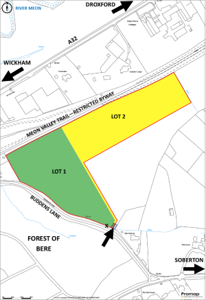
LOCATION: See Location Plan. The Property is located just within the South Downs National Park close to the hamlet of Woodend in the Parish of Soberton and within ¼ mile of the A32 main road approximately 2 miles north-east of Wickham. It is in the Meon Valley with the River Meon across the A32 less than 300 yards away. The Property is bounded by the historic and picturesque Meon Valley Trail to the north with the Forest of Bere across Budden's Lane to the south. What3Words: ///stream.thousands.decks.
DIRECTIONS: From Wickham: Head north on the A32, after approximately 1.9 miles turn right off A32 signed Soberton Heath and Newtown into Budden's Lane. Proceed down the lane, over the bridge that crosses the Meon Valley Trail and continue for approximately ¼ mile. The property is accessed via a double gateway on the left immediately before a residential property 'High Clearing' and a sharp right hand bend.
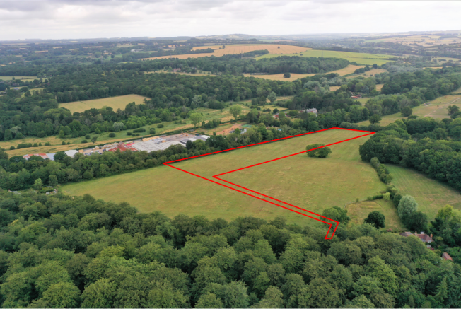
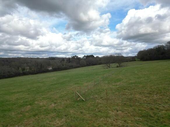
DESCRIPTION: See Site Plan. The Property extends to 11.34 acres (4.59ha) of permanent pasture in a single block. The boundaries consist mainly of post and wire fencing with mature hedging and trees. The Property benefits from good road frontage and access from Budden's Lane. The boundary between Lot 2 and neighbouring land to the south is new post and wire fencing. There are residential properties to the north between Meon Valley Trail and the A32 and on both sides of the Property fronting onto Budden's Lane. The Land has previously been used for grazing livestock.
According to the Agricultural Land Classification the land is Grade 4. The Geological Survey Map indicates that the Property is within an area of slowly permeable seasonally wet slightly acid but base-rich loamy and clayey soils. The land has a northerly aspect and slopes into the valley towards the River Meon. The highest point near the access is 66m above sea level, the lowest point on the northern boundary is around 42m above sea level.
The Property is being offered as a whole or in up to two Lots. See Site Plan. There is currently no internal fencing between the Lots. If the Property is sold in Lots the new owner of Lot 1 will be responsible for erecting fencing on its boundary with Lot 2. The boundaries between the Lots are marked with coloured pegs on-site.
LAND REGISTRY TITLE: The Property consists of part of Land Registry Title HP768329. Please see Additional Documents for Copies of Register and Plan.
ACCESS: The main vehicular access off Budden's Lane is identified by the arrow on the Site Plan. There is a right of access over neighboring land hatched blue on the Site Plan providing access to both Lots. A further right of way (4.5m wide) for the benefit of Lot 2 will be provided over Lot 1 -see the black hatched area on the Site Plan. That is unless the two Lots are sold to the same purchaser. Any improvement to the surface of the access width is likely to require planning consent.
HORSE RIDING: Membership of TROT (Toll Rides Off-road Trust) will give horse riders the right to enjoy scenic horse ride through the nearby forest trails at West Walk, Hundred Acres and Woodend. There are 11 horse gates to access the forest.
SERVICES: The Property benefits from a mains water supply with a trough in Lot 1 on the boundary with Budden's Lane at the position marked X on the Site Plan. Mains Electricity is not connected but is likely to be available close by.
PUBLIC RIGHT OF WAY: No Public Rights of Way cross the Property. There is good access from the Property to the local public rights of way network using the Meon Valley Trail (Restricted Byway). Although no access currently exists directly from the land to the trail, access routes could be created from Lots 1 and 2 through the fenceline along the northern boundary. Interested parties should make their own enquiries on this matter. It is also possible that the trail may be accessed via common land to the west of the property. The Trail, a disused railway line, provides an easy and safe route from Wickham approximately 2 miles south-west to West Meon approximately 7 miles north-east passing through other settlements on the way and connecting with other parts of the public rights of way network. It can be used for walking, cycling or horse riding. See Site Plan and Location Plan 1.
OVERAGE: The Vendor is mindful to retain a 30% share of any uplift in value caused by a planning consent for any development within a 25 year period but excluding any equestrian or agricultural development.
PLANNING: The Property is within the South Downs National Park and the Local Plan shows the land to be 'Countryside'. There is a mineral safeguarding area protecting sharp sand and gravel resources affecting a small part of the site on the southern boundary. The only recent planning application relating to the Property in the past 10 years is an application and subsequent appeal for the erection of stable building, an all weather exercise area and associated works on the property in 2014 which were not consented.
PLANNING AUTHORITY: South Downs National Park, North Street, Midhurst, West Sussex, GU29 9DH.
LOCAL AUTHORITY: Winchester City Council, City Offices, Colebrook Street, Winchester, SO23 9LJ.
BIODIVERSITY NET GAIN (BNG): There may be the potential for parts of the Property to be managed in a way, or with new habitats established, to be suitable for use as part of the new requirement for development to provide a 10% biodiversity net gain. Such BNG Credits can then be sold to developers.
Brochures
Sales Particulars
NEAREST STATIONS
Distances are straight line measurements from the centre of the postcode- Botley Station4.6 miles
- Fareham Station5.0 miles
- Swanwick Station5.8 miles
About the agent
Giles Wheeler-Bennett, Southampton
West Court, Lower Basingwell Street, Bishop's Waltham, SO32 1AJ
Giles Wheeler-Bennett Chartered Surveyors & Land Agents is an established multi-disciplined land agency company practising throughout Hampshire and the surrounding counties and specializing in all aspects of rural property management.
We are an experienced team offering our clients a comprehensive, professional and friendly services and operate from an office in the historic market town of Bishop's Waltham.
Benefitting from an abundance of local knowledge and a reputable name, we
Notes
Disclaimer - Property reference BuddenLot2. The information displayed about this property comprises a property advertisement. Rightmove.co.uk makes no warranty as to the accuracy or completeness of the advertisement or any linked or associated information, and Rightmove has no control over the content. This property advertisement does not constitute property particulars. The information is provided and maintained by Giles Wheeler-Bennett, Southampton. Please contact the selling agent or developer directly to obtain any information which may be available under the terms of The Energy Performance of Buildings (Certificates and Inspections) (England and Wales) Regulations 2007 or the Home Report if in relation to a residential property in Scotland.
Map data ©OpenStreetMap contributors.