
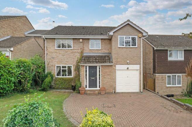
Briarswood Way, Orpington
- PROPERTY TYPE
Detached
- BEDROOMS
4
- BATHROOMS
2
- SIZE
Ask agent
- TENUREDescribes how you own a property. There are different types of tenure - freehold, leasehold, and commonhold.Read more about tenure in our glossary page.
Freehold
Key features
- OPEN PLAN LIVING
- PLAYROOM
- SEPARATE RECEPTION
- CLOAKROOM
- ENSUITE TO MASTER
- GARAGE & UTILITY SPACE
- SOUTH FACING GARDEN
- CLOSE TO WARREN ROAD SCHOOL AND MULTIPLE STATIONS
- FREEHOLD PROPERTY
- BROMLEY COUNCIL TAX BAND G AND EPC RATING D
Description
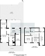
The property is well presented throughout and the ground floor accommodation briefly comprises, enclosed porch, entrance hallway with deep storage cupboards, spacious separate reception room with log burning stove, and double doors leading to a playroom which could be used as a study.
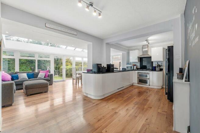
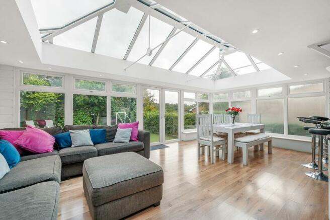
The open plan kitchen/diner has a range of wall and base units with granite worksurfaces, integrated dishwasher, built-in oven and gas hob with extractor, space for fridge freezer and breakfast bar. The extended family room is a great space for entertaining and has french doors to the garden. The property also benefits from an internal door to the garage incorporating a utility space and there is a cloakroom with hand wash basin and vanity storage.
Other features to note: laminate wood effect flooring, bespoke blinds, ADT security alarm, leaded light windows.
To the first floor there are three double bedrooms and a single, some with a range of fitted wardrobes, ensuite shower room and a family bathroom with panel bath, separate shower enclosure, heated towel rail and vanity storage. The property also benefits from a part boarded loft space with ladder and light.
Outside, the south facing rear garden is secluded by mature trees and shrubs, has a patio seating area and two storage sheds. To the front there is a block paved driveway for a couple of cars, garage with power and light and gated side access.
Briarswood Way is a short walk from the shops on Windsor Drive, Crescent Way and Green Street Green High Street, both with an array of convenience stores, There are further shopping facilities in Orpington and Bromley and the M25 can be joined nearby for major road networks, Gatwick and Heathrow airports.
Brochures
Full DetailsCouncil TaxA payment made to your local authority in order to pay for local services like schools, libraries, and refuse collection. The amount you pay depends on the value of the property.Read more about council tax in our glossary page.
Band: G
Briarswood Way, Orpington

NEAREST STATIONS
Distances are straight line measurements from the centre of the postcode- Chelsfield Station0.7 miles
- Orpington Station1.2 miles
- Knockholt Station1.9 miles

About the agent
Langford Rae Property Agents, Chelsfield
49 Windsor Drive, Chelsfield, Orpington, BR6 6EY
We're doing everything we can to support all of our clients while keeping the company moving forward. We are working our normal hours with access to our telephone and computer systems and we're happy to send out video tours of our properties where possible, this will enable you to chat to us about your house move process.
We'll continue to be available on our office number and on our social media channels, so if you're planning a move or thinking of selling or letting we'd very much lik
Notes
Staying secure when looking for property
Ensure you're up to date with our latest advice on how to avoid fraud or scams when looking for property online.
Visit our security centre to find out moreDisclaimer - Property reference 11879949. The information displayed about this property comprises a property advertisement. Rightmove.co.uk makes no warranty as to the accuracy or completeness of the advertisement or any linked or associated information, and Rightmove has no control over the content. This property advertisement does not constitute property particulars. The information is provided and maintained by Langford Rae Property Agents, Chelsfield. Please contact the selling agent or developer directly to obtain any information which may be available under the terms of The Energy Performance of Buildings (Certificates and Inspections) (England and Wales) Regulations 2007 or the Home Report if in relation to a residential property in Scotland.
*This is the average speed from the provider with the fastest broadband package available at this postcode. The average speed displayed is based on the download speeds of at least 50% of customers at peak time (8pm to 10pm). Fibre/cable services at the postcode are subject to availability and may differ between properties within a postcode. Speeds can be affected by a range of technical and environmental factors. The speed at the property may be lower than that listed above. You can check the estimated speed and confirm availability to a property prior to purchasing on the broadband provider's website. Providers may increase charges. The information is provided and maintained by Decision Technologies Limited.
**This is indicative only and based on a 2-person household with multiple devices and simultaneous usage. Broadband performance is affected by multiple factors including number of occupants and devices, simultaneous usage, router range etc. For more information speak to your broadband provider.
Map data ©OpenStreetMap contributors.