Cole Hill, SO32

- PROPERTY TYPE
Land
- SIZE
130,680 sq ft
12,141 sq m
Key features
- SEE AND PRINT PDF SALES PARTICULARS AVAILABLE BELOW
- SEE VIDEO FOOTAGE ON THE VIRTUAL TOUR TAB
- APPROX. 3.00 ACRES IN ALL
- FENCED
- 2 FIELD SHELTERS
- SHARED ACCESS
- HEART OF THE VILLAGE - CLOSE TO THE PUB AND CHURCH
- CLOSE TO THE MEON VALLEY TRAIL
- ARTICLE 4 DIRECTION - FENCING
- PUBLIC FOOTPATH PASSING THROUGH
Description
VIDEO FOOTAGE: See the website and further details, photographs and video footage is available showing the whole Property.
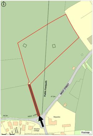
LOCATION AND DIRECTIONS: See Location Plans 1 and 2. Main vehicular access. What3Words: 3PJ. Access to The Footpath off West Street is through the metal kissing-gate approximately 20 yards to the east (right) of the vehicular gate.
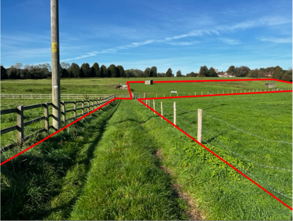
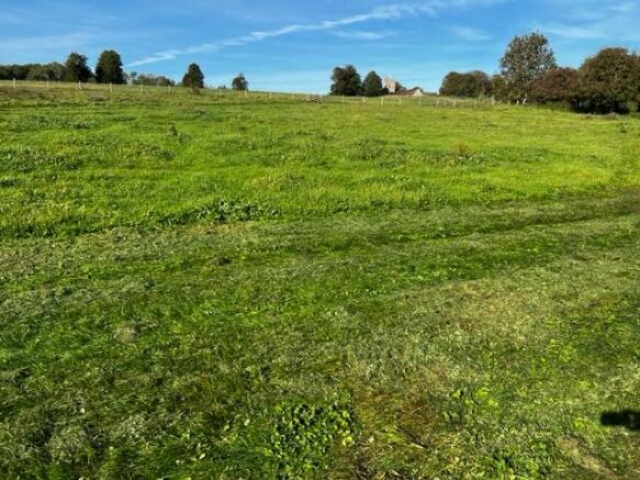
DESCRIPTION: The land extends to 3.00 acres (1.21 Ha) in all as outlined red on the Site Plan. This area includes the shared grass access track (0.10 acre) shaded brown. The pasture is well drained and grazing is possible all year round. The land gently slopes down to the south. At times of high rainfall in winter months there are small areas of low spots where water lies along the fenced boundary. The River Meon and Meon Valley Trail (Disused Railway) are close by and to the west, along West Street.
LAND REGISTRY: The land comprises the entirety of Land Registry Title No. HP769494 including the shared access track off West Street which is included in this title as shown by documents available on the Selling Agent's website.
FENCING: The Vendor is responsible for maintaining all the fences surrounding this parcel of land and the access track.
FIELD SHELTERS: The two wooden shelters are included in the Property and Price Guide.
SHARED ACCESS: 3 other owners of adjoining parcels of land have rights of access over the grass track at all times but for agricultural or equestrian purposes only and they shall contribute a fair proportion of any maintenance of the track according to use. The main gate is secured by a shared padlock with combination code.
EQUESTRIAN USE: The Land has been used for grooming, tacking up and riding horses for approx. 10 years. Horses have been supplementary fed in the winter too.
PLANNING: There is no Planning History. The land lies within the South Downs National Park. See contact details below.
DESIGNATIONS: There are no environmental designations over the land.
SERVICES: Metered mains water is connected to a tap. A trough and baths are on site to allow for grazing of smaller areas contained by temporary electric tape.
ARTICLE 4 DIRECTION: See Selling Agent's website for document. An Article 4 Direction was placed over the Property and all adjoining pasture land in October 2007. The effect of this is to require that any additional permanent fencing or gates cannot be erected without prior planning consent. This is to protect the landscape. Planning consent for additional fencing is possible and was achieved for a section of post and wire fence on a neighbouring land on 10th July 2014. See link to planning - Ref: SDNP/14/01286/FUL
PUBLIC RIGHTS OF WAY: A Public Footpath passes through the land with a stile and kissing gate at the boundary fences. Access the footpath either off West Street or from the Church or White Lion Pub further north. See Extract of Definitive Plan on Selling Agent's website.
LOCAL AUTHORITY: Winchester City Council (WCC), City Offices, Colebrook Street, Winchester SO23 9LJ.
SOUTH DOWNS NATIONAL PARK (SDNP): South Downs Centre, North Street, Midhurst, West Sussex GU29 9DH.
OFFER INSTRUCTIONS: Please see the Additional Document on our website for instructions as to how to make an offer by Private Treaty.
Brochures
Sales ParticularsCole Hill, SO32

NEAREST STATIONS
Distances are straight line measurements from the centre of the postcode- Botley Station5.7 miles
About the agent
Giles Wheeler-Bennett, Southampton
West Court, Lower Basingwell Street, Bishop's Waltham, SO32 1AJ
Giles Wheeler-Bennett Chartered Surveyors & Land Agents is an established multi-disciplined land agency company practising throughout Hampshire and the surrounding counties and specializing in all aspects of rural property management.
We are an experienced team offering our clients a comprehensive, professional and friendly services and operate from an office in the historic market town of Bishop's Waltham.
Benefitting from an abundance of local knowledge and a reputable name, we
Notes
Disclaimer - Property reference ChurchMeadow. The information displayed about this property comprises a property advertisement. Rightmove.co.uk makes no warranty as to the accuracy or completeness of the advertisement or any linked or associated information, and Rightmove has no control over the content. This property advertisement does not constitute property particulars. The information is provided and maintained by Giles Wheeler-Bennett, Southampton. Please contact the selling agent or developer directly to obtain any information which may be available under the terms of The Energy Performance of Buildings (Certificates and Inspections) (England and Wales) Regulations 2007 or the Home Report if in relation to a residential property in Scotland.
Map data ©OpenStreetMap contributors.