Land at Harts Lane, Burghclere, Hampshire RG20 9JZ

- SIZE
Ask agent
- SECTOR
Land for sale
Key features
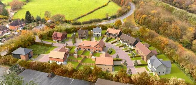
- Resolution to grant for 17 units and a community hub (ref: 22/03203/FUL)
- Mix of one, two, three and four bed dwellings and small office space
- Provision for seven affordable units to be delivered on site
- S106 is progressed and due to be sealed imminently
- Total Site area of approximately 0.89 hectares (2.2 acres)
- Proposed accommodation totalling approximately 18,409 sq. ft. (1,710 sq. m.)
- Community Hub/Office Space of approximately 1,616 sq. ft. (150 sq. m.)
- Offered with vacant possession
- Unconditional offers are invited by noon on Thursday 22nd February 2024
Description
The site is located on the western edge of Burghclere village in Hampshire. The site extends to approximately 2.2 acres (0.89 hectares), is relatively flat in nature and semi ellipse in shape, being bounded by mature shrubs, hedgerows and trees. The immediate area to the site comprises residential dwellings, commercial buildings and agricultural land.
Brochures
Land at Harts Lane, Burghclere, Hampshire RG20 9JZ

NEAREST STATIONS
Distances are straight line measurements from the centre of the postcode- Newbury Station3.8 miles
- Newbury Racecourse Station4.0 miles
- Thatcham Station5.4 miles
About Savills, Reading
Ground Floor, Hawker House, 5-6 Napier Court, RG1 8BW
Notes
Disclaimer - Property reference 96D14BAA-E978-4E1D-AA5F-C58414756B29. The information displayed about this property comprises a property advertisement. Rightmove.co.uk makes no warranty as to the accuracy or completeness of the advertisement or any linked or associated information, and Rightmove has no control over the content. This property advertisement does not constitute property particulars. The information is provided and maintained by Savills, Reading. Please contact the selling agent or developer directly to obtain any information which may be available under the terms of The Energy Performance of Buildings (Certificates and Inspections) (England and Wales) Regulations 2007 or the Home Report if in relation to a residential property in Scotland.
Map data ©OpenStreetMap contributors.