Gartnafuran Forest, Balquhidder, Perthshire, FK19

- PROPERTY TYPE
Land
- SIZE
24,436,768 sq ft
2,270,252 sq m
Description
Land Classification and Soil Type / Association
The soils are classified by The James Hutton Institute as predominantly humus iron podzols which peaty gleys soils from the Sourhope Soil Association.
Land Capability for forestry is understood to be as follows :-
F4— land with moderate flexibility for the growth and management of tree crops.
F5 – land with limited flexibility for the growth and management of tree crops.
F6— land with very limited flexibility for the growth and management of tree crops.
Altitude and Aspect
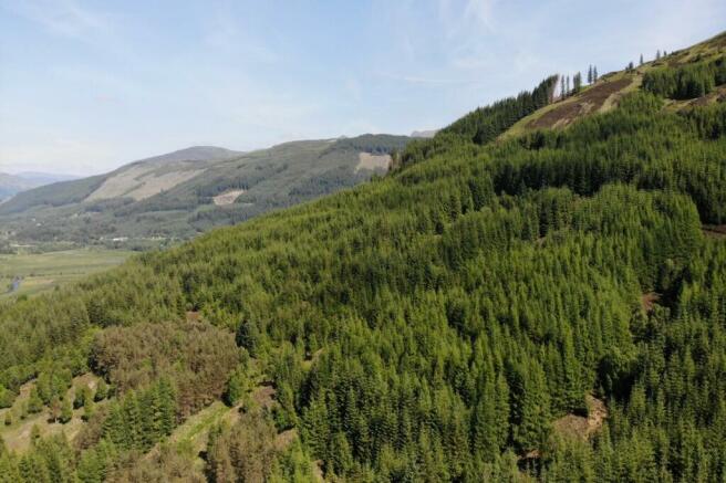
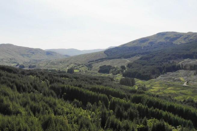
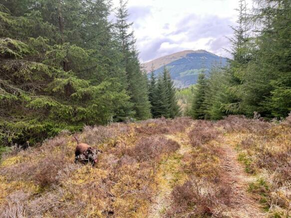
The woodland lies between the 150 and 560 metre contours above sea level (approximately). The forest rises gently along Glen Buckie to Buachaille Breige with some steep areas in places to Buachaille Breige and has therefore both a northerly and westerly aspect.
Cropping and Stocking
The woodland comprises mixed conifers with Sitka spruce being the most prominent and broadleaves of relatively uniform ages, which can be summarised as noted below.
Gartnafuaran Forest is in an excellent condition with very little areas of localised windblow. The majority of the forest was planted between 1992 and 1993 and is all growing well.
The Yield class for the areas of Sitka spruce YC being 16-22, Larch being approximately YC 8 -14, and the areas of mixed broadleaves being YC 2-4. These are all about average for these species.
There are no other signs of disease present. The open space is mainly located around the internal access tracks and turning areas.
Gartnafuaran Forest is predominantly commercial. Approximately 63% is commercial forest mainly conifer species and the remaining 37% is diverse woodland consisting of native broadleaves and open ground. There is potential for an early income stream from tree harvesting although this could be deferred. There is also a power wayleave in place with generates a small annual income.
Drainage and Water Supplies / Irrigation
The Calair Burn lies in the west of the property and is fed from within Gartnafuaran Forest by unnamed watercourses.
Forest Size and Fencing
The forest extends to approximately 227.03 hectares (561acres) and lies in a single block.
The woodlands are not fully enclosed. The combination of post and wire, stone dyke and metal rail fences lies on the northerly boundary. The fencing is maintained on a mutual basis with the neighbouring properties. The easterly and westerly boundary is open, as is part of the southern boundary, the balance being demarcated by a fence.
Grants / Subsidies / IACS / Other Schemes
There is an approved long term forest plan - 21FGS60123
Sporting
The sporting rights are owned and are included in the sale. We understand that the sporting rights have, in the past, been let out. The last annual deer cull figures available are 38 Red Deer and 24 Roe Deer. This is also the potential for fly fishing in the Calair Burn.
Agricultural, Conservation and Environmental Designations
The subjects are designated as Less Favoured Area (Seriously Disadvantaged, on the SGRPID portal. We are not aware of any conservation or environmental designations.
Contamination, Ground Conditions and Flooding
It is not known of any other previous use which would have resulted in the land being included in any register of contaminated land. No investigations into such matters have been carried out. No evidence of invasive / non-native species or asbestos containing materials were noted.
The flood risk map does not indicate any issues of flooding from river or surface water. The risk of flooding reported does not, however, take into account any flood defences which may be in place now or in the future or impact any change of use.
While the topography of the subjects results in some steep slopes the construction of a new forest road would enable the extraction of timber and access for contractors for harvesting, planting and routine maintenance.
Burdens and Third Party Rights
There is an existing right by a third party to take water from one of the forest streams.
The property is sold under the conditions of the Title Deeds, subject to all Servitude Rights, burdens, reservations, and wayleaves including rights of way and rights of access howsoever constituted.
The purchaser shall be held responsible to satisfy themselves as to the nature of all burdens, should they exist. Further details can be obtained via the selling agents. Title deeds will be exhibited to the purchaser’s legal agents for examination.
Archaeology
No archaeological features have been identified on site.
Minerals
Mineral rights are included, except as provided for by statute.
Plans and Areas
These are based on the Ordnance Survey and are for reference only. The purchaser shall be deemed to have satisfied themselves as to their accuracy and any error shall not annul the sale or entitle any part to compensation in respect thereof.
VAT
In the event that the seller has elected to tax, VAT may be payable on the purchase price.
Scottish Government Rural Payments and Inspections Directorate (SGRPID)
Strathearn House, Broxden Business Park, Lamberkine Drive, Perth PH1 1RX
Local Scottish Forestry Office
Perth and Argyll Conservancy, Upper Battleby, Redgorton, Perth PH1 3EN
Local Authority
Stirling Council, 1 – 5 Port Street, Stirling, FK8 2EJ
Viewings and Closing Date
Viewing is strictly by appointment with the selling agents. It is anticipated that a closing date for offers will be set and those interested in the property are strongly advised to register their interest with the selling agent. The owner reserves the right to sell without setting a formal closing date and the seller is not bound to accept the highest or indeed any offer.
Brochures
ParticularsGartnafuran Forest, Balquhidder, Perthshire, FK19

NEAREST STATIONS
Distances are straight line measurements from the centre of the postcode- Crianlarich Station9.9 miles
About the agent
Bell Ingram, Perth
Durn, Isla Road, Perth, PH2 7HF
A Team You Can Trust
We understand that the decision to sell is never easy. The relationship between our agents and clients is based on trust and our team will give you the confidence that we will be able to achieve the best outcome for you. Drawing on over 100 years' experience, our professionals ensure your expectations are exceeded.
Industry affiliations


Notes
Disclaimer - Property reference PER240030. The information displayed about this property comprises a property advertisement. Rightmove.co.uk makes no warranty as to the accuracy or completeness of the advertisement or any linked or associated information, and Rightmove has no control over the content. This property advertisement does not constitute property particulars. The information is provided and maintained by Bell Ingram, Perth. Please contact the selling agent or developer directly to obtain any information which may be available under the terms of The Energy Performance of Buildings (Certificates and Inspections) (England and Wales) Regulations 2007 or the Home Report if in relation to a residential property in Scotland.
Map data ©OpenStreetMap contributors.