
Stapleton, Presteigne, Herefordshire, County

- SIZE
Ask agent
- TENUREDescribes how you own a property. There are different types of tenure - freehold, leasehold, and commonhold.Read more about tenure in our glossary page.
Ask agent
Description
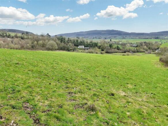
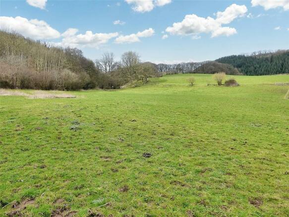
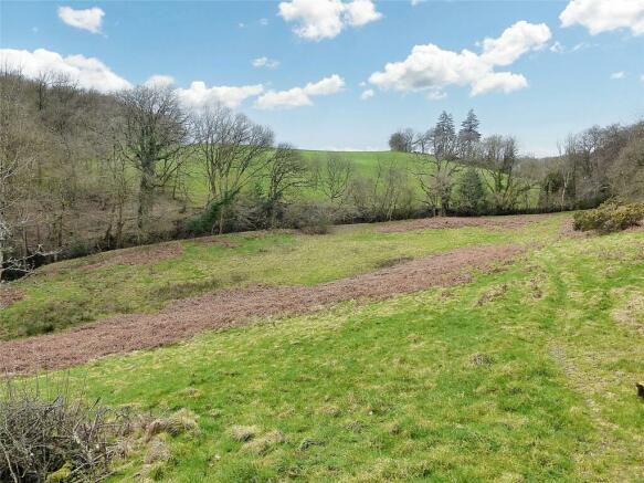
Productive livestock grazing, oak and broadleaf woodland.
Roadside frontage
Natural water available in part
Diversification opportunities (subject to planning)
Possible natural capital, carbon and bio-diversity enhancement opportunities
16.98 acres est. (6.87 hectares est.)
For sale by Informal Tender (subject to prior sale):
Tenders close Friday 31st May 2024 at midday.
THE LAND
The land is contained within one block, extending in all to approximately 16.98 acres (6.87 hectares). The land is conveniently situated approximately 1.5 miles north of the popular town of Presteigne, 8 miles north of Kington and approximately 6 miles south of the town of Knighton. The land has good roadside access directly onto an unclassified council-maintained road. The land is currently laid down to permanent pasture and oak and broadleaf woodland and provides good livestock grazing and natural capital assets. The land benefits from a natural water supply in part and is easily accessed via a gateway directly onto the unclassified council-maintained road running from Stapleton to Willey. The topography and nature of the land may offer additional biodiversity and natural capital opportunities, and subsequently provide possible income generation and capital growth in future. The land benefits from a plethora of biodiversity in the form of mature trees, hedgerows and (truncated)
PERMANENT PASTURE & MIXED WOODLAND
A good block of sloping permanent pasture and mixed woodland, contained within 4 enclosures, extending to approximately 16.98 acres (6.87 hectares). The land is bounded by mixed species hedges and post and netting fence boundaries, with access directly onto the council-maintained road.
SPORTING RIGHTS
Sporting rights will be included in the sale as they may be held by the Vendor.
MINERAL RIGHTS
Mineral rights will be included in the sale as they may be held by the Vendor.
TIMBER
Any standing timber is included in the sale.
RURAL PAYMENTS AGENCY
The land has been registered with the Rural Payments Agency in previous years. The land is situated in the English region. The land may have an opportunity to enter into the Rural Payments Agency Countryside Stewardship, or Sustainable Farm Incentive Schemes, if required by potential purchasers.
ENVIRONMENTAL STEWARDSHIP
None
INGOINGS
The land is sold free from ingoings.
SERVICES
None
TENURE
We have been informed that the land is freehold with vacant possession upon completion.
FIXTURES AND FITTINGS
Those items mentioned in the sale particulars are included in the freehold sale. All other fixtures and fittings and furnishings are expressly excluded.
EASEMENTS, WAYLEAVES AND RIGHTS OF WAY
The property is offered subject to, and with the benefit of, any rights-of-way both public and private, all wayleaves, easements and other rights whether or not specifically referred to.
TOWN AND COUNTRY PLANNING
The property is offered subject to any development plans, tree preservation orders, ancient orders, public rights-of-way, town planning schedules, or resolutions which may be or may come into force. The purchaser(s) will be deemed to have full knowledge of these and have satisfied themselves as to the effects such matters have on the property.
AUTHORITIES
Herefordshire Council: Rural Payment Agency:
PLANS, AREAS AND SCHEDULES
These are based on Ordnance Survey and are for reference only. They have been checked and compiled by the vendor's agents and the purchaser(s) shall be deemed to have satisfied themselves as to the description of the property. Any error or misstatement shall not annul a sale or entitle any party to compensation in respect thereof.
BOUNDARIES, ROADS AND FENCES
The purchaser(s) shall be deemed to have full knowledge of the boundaries and neither the Vendor nor the Vendors agents will be responsible for defining the boundaries of ownership thereof. The Vendor will reserve a right of way for all purposes from point A to point B on the attached map, to gain access by vehicle, animal or foot to the vendors retained land. The purchaser will be responsible for the maintenance of the access.
DIRECTIONS
From the town of Presteigne take the road for Stapleton for approximately 1.5 miles. The land can be found on the left hand side of this road. McCartneys sale board will be placed on the gate entrance.
GRID REFERENCE:
SO :50,000
WHAT3WORDS
///grapevine.expired.showcases
ANTI MONEY LAUNDERING
The successful purchaser should please provide a photographic form of ID such as driver's licence or passport, and a utility bill or bank statement confirming their home address.
METHOD OF SALE
The property is offered for sale by Informal Tender (unless previously sold). The tender forms are available from the Vendor's agents. Tenders close Friday 31st May 2024 at midday. Tenders are to be delivered to; McCartneys LLP, 54 High Street, Kington, Herefordshire, HR5 3BJ marked "Tender - Land at Stapleton". The Vendor reserves the right not to accept the highest, or indeed, any offer. The Vendor reserves the right to accept offers prior to the tender date.
PRICE GUIDE
Offers in the region of £110,000 to £130,000
Brochures
ParticularsEnergy performance certificate - ask agent
Council TaxA payment made to your local authority in order to pay for local services like schools, libraries, and refuse collection. The amount you pay depends on the value of the property.Read more about council tax in our glossary page.
Band: TBC
Stapleton, Presteigne, Herefordshire, County

NEAREST STATIONS
Distances are straight line measurements from the centre of the postcode- Knighton Station4.5 miles

About the agent
McCartneys LLP, Hay-On-Wye
11 High Town, Hay-On-Wye, HR3 5AE
McCartneys LLP is the leading independent Auctioneers, Estate Agents, Chartered Surveyors and Valuers in the Marches, Mid Wales and West Midlands, with seventeen Property Offices and five Livestock Centres covering 4 counties.
The original Partnership, established in 1874, has developed into a strong independent professional firm serving its' clients throughout the West Midlands and Welsh Borders, with pride and expertise.
Notes
Staying secure when looking for property
Ensure you're up to date with our latest advice on how to avoid fraud or scams when looking for property online.
Visit our security centre to find out moreDisclaimer - Property reference HAY240090. The information displayed about this property comprises a property advertisement. Rightmove.co.uk makes no warranty as to the accuracy or completeness of the advertisement or any linked or associated information, and Rightmove has no control over the content. This property advertisement does not constitute property particulars. The information is provided and maintained by McCartneys LLP, Hay-On-Wye. Please contact the selling agent or developer directly to obtain any information which may be available under the terms of The Energy Performance of Buildings (Certificates and Inspections) (England and Wales) Regulations 2007 or the Home Report if in relation to a residential property in Scotland.
*This is the average speed from the provider with the fastest broadband package available at this postcode. The average speed displayed is based on the download speeds of at least 50% of customers at peak time (8pm to 10pm). Fibre/cable services at the postcode are subject to availability and may differ between properties within a postcode. Speeds can be affected by a range of technical and environmental factors. The speed at the property may be lower than that listed above. You can check the estimated speed and confirm availability to a property prior to purchasing on the broadband provider's website. Providers may increase charges. The information is provided and maintained by Decision Technologies Limited. **This is indicative only and based on a 2-person household with multiple devices and simultaneous usage. Broadband performance is affected by multiple factors including number of occupants and devices, simultaneous usage, router range etc. For more information speak to your broadband provider.
Map data ©OpenStreetMap contributors.