Brinkmarsh Lane, Falfield, Wotton-under-Edge, Gloucestershire, GL12

- PROPERTY TYPE
Farm House
- SIZE
Ask agent
- TENUREDescribes how you own a property. There are different types of tenure - freehold, leasehold, and commonhold.Read more about tenure in our glossary page.
Ask agent

Key features
- Period Farmhouse with Annexe
- Substantial Farm Buildings
- Rural Location
- Additional Paddocks (Lot 2 & 3), See Particulars
Description
Description
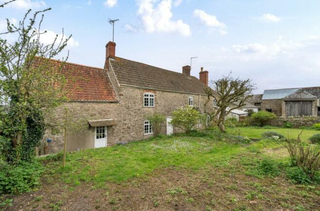
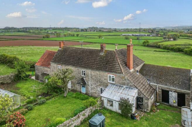
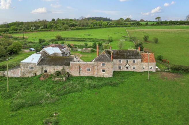
Horseshoe Farm is an attractive farmstead comprising of a detached four-bedroom character farmhouse, with two-bedroom annexe, extensive range of traditional outbuildings and stabling, and grounds, all extending to approximately 0.75 acres (0.31ha). Recently, the property has been in equestrian use, with the historic use as a Dairy Farm. The farmstead extends to circa 0.75 acres, all contained within a stone wall boundary, and includes the residential property, gardens, outbuildings, and yard. The garden, to the front of the house, is walled and comprises lawn, herbaceous borders, vegetable garden and greenhouse, with flagstone pathways. There is a central yard, around which the house and main range of buildings are positioned and a useful secondary area, at the entrance to the property.
Situation
Horseshoe Farm is located on Brinkmarsh Lane, surrounded by privately owned agricultural land. The property is a short distance from the A38, which gives access to the local village of Falfield and the market town of Thornbury (3.5 miles). There are excellent local transport links, with Junction 14 of the M5 being 2.5 miles north. The land known as Mudpatch and Kitcat are within close proximity to the farmstead, with frontage from Cromhall Lane and Cuttsheath Road respectively.
Buildings
There are a range of well-maintained outbuildings, extending to approximately 4,000ft2 with a range of concrete, hardcore, and cobble yards. The Threshing Barn sits centrally within the site and is of stone elevations offering scope for alternative uses, subject to obtaining the necessary planning consent.
Agents Notes
The land filled green on the Horseshoe Farm plan falls outside of the Vendors ownership but has been used by the occupants for several years. The adjoining landowner may consider a sale of this land, by separate negotiation.
Services
The farmstead property benefits from mains electricity and water, with drainage to a septic tank, located in the field to the north. Heating within the farmhouse is oil fired, with coal fired central heating in the annexe.
General
South Gloucestershire Council EPC – E Council Tax Band – G
Viewing
Strictly by appointment with the Agents: David James Tel: .
Brochures
ParticularsCouncil TaxA payment made to your local authority in order to pay for local services like schools, libraries, and refuse collection. The amount you pay depends on the value of the property.Read more about council tax in our glossary page.
Band: TBC
Brinkmarsh Lane, Falfield, Wotton-under-Edge, Gloucestershire, GL12

NEAREST STATIONS
Distances are straight line measurements from the centre of the postcode- Yate Station5.3 miles
About the agent
David James, Wotton-under-Edge
Well House, The Chipping, Wotton-Under-Edge, GL12 7AD
David James act in the sale, letting and valuation of all types of commercial property including offices, workshop, retail and storage premises. Historically, acting in the management of rural business lets, our service has expanded to manage investment portfolios, urban and high street properties for our retained clients, advising on lease renewal and end of tenancy matters and ensuring rent collections.
Notes
Staying secure when looking for property
Ensure you're up to date with our latest advice on how to avoid fraud or scams when looking for property online.
Visit our security centre to find out moreDisclaimer - Property reference WEC240258. The information displayed about this property comprises a property advertisement. Rightmove.co.uk makes no warranty as to the accuracy or completeness of the advertisement or any linked or associated information, and Rightmove has no control over the content. This property advertisement does not constitute property particulars. The information is provided and maintained by David James, Wotton-under-Edge. Please contact the selling agent or developer directly to obtain any information which may be available under the terms of The Energy Performance of Buildings (Certificates and Inspections) (England and Wales) Regulations 2007 or the Home Report if in relation to a residential property in Scotland.
*This is the average speed from the provider with the fastest broadband package available at this postcode. The average speed displayed is based on the download speeds of at least 50% of customers at peak time (8pm to 10pm). Fibre/cable services at the postcode are subject to availability and may differ between properties within a postcode. Speeds can be affected by a range of technical and environmental factors. The speed at the property may be lower than that listed above. You can check the estimated speed and confirm availability to a property prior to purchasing on the broadband provider's website. Providers may increase charges. The information is provided and maintained by Decision Technologies Limited. **This is indicative only and based on a 2-person household with multiple devices and simultaneous usage. Broadband performance is affected by multiple factors including number of occupants and devices, simultaneous usage, router range etc. For more information speak to your broadband provider.
Map data ©OpenStreetMap contributors.