Shelfanger Road, Diss, Norfolk, IP22

- SIZE AVAILABLE
904,168 sq ft
84,000 sq m
- SECTOR
Land for sale
Key features
- The site was allocated under policy DDNP1 in the Diss and District Neighbourhood Plan
- Outline planning permission has been granted for up to 179 dwellings with 33% Affordable Housing
- Site not affected by nutrient neutrality
- The S106 agreement has been completed
- All matters are reserved apart from access
- A full suite of documents is available in the data room and you will be notified of any new documents as they are uploaded
- Unconditional written offers for the freehold interest are invited
Description
Diss is a thriving market town in south Norfolk, located to the north-west of the A140 / A143 junction and with a railway station on the Norwich - London Liverpool Street line, meaning that the town is less than 20 minutes from Norwich and Stowmarket and approximately 90-100 minutes from London. There is also a small bus station just outside the town centre with services linking to Norwich, Bury St Edmunds and a range of key regional settlements as well as other local towns and villages. These good transport connections make Diss a sustainable location for new housing.
The Greater Norwich Local Plan ('GNLP') identifies Diss as a Main Town under policy 7.2. It has a strong local employment base and supports three main supermarkets, a wide range of local shops and services in the town centre, and a full range of facilities including a secondary school, GPs, leisure centre, library, and a variety of sports clubs.
The continuous built-up area of the town falls within the parishes of Diss and Roydon, giving the town a population of almost 10,000 people. Sites have been allocated in the 2003 and 2015 South Norfolk Local Plans which have maintained the growth of the town over recent years.
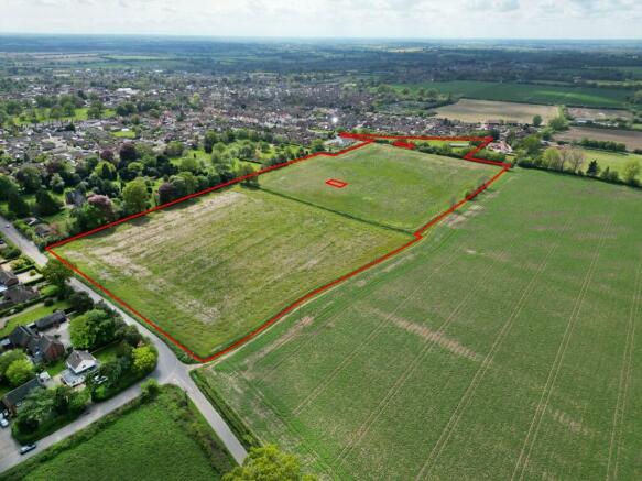
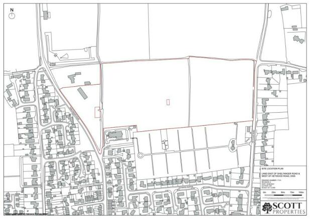
SITE DESCRIPTION
The site extends to 8.4 Ha / 20.75 acres of mostly arable land and is located within the northern extent of Diss between Shelfanger Road to the west and Heywood Road to the east. It is bordered by agricultural land along the north-eastern boundary and a residential bungalow, beyond which is the Diss Sports Ground and Skate Park on the north-western side. The St Henry Morse Roman Catholic Church and Diss Cemetery lie to the south.
A public right of way runs through the site north-south (RB25) and another public footpath runs immediately beyond the northern boundary (FP7/FP26). The land on the west side of RB25 lies within the Parish of Roydon with the remainder and majority of the site being within the Parish of Diss. The site is less than 1km north of Diss town centre, and Shelfanger Road
and Heywood Road are residential in character.
The site contains two small parcels of land which are excluded from the sale as they are in separate ownership to the remainder of the site. Neither parcel is included in the planning permission.
PLANNING
The site was allocated in the Diss and District Neighbourhood Plan (adopted 2023) under policy DDNP 1. Following this outline planning permission was granted by South Norfolk Council on 11 January 2024 under reference 2021/2782 for the erection of up to 179 dwellings, 0.64 Ha of land for the future extension of Diss Cemetery, a new road linking Shelfanger Road and Heywood Road/Burston Road, public open space, and associated infrastructure and landscaping. All matters are reserved apart from access.
NUTRIENT NEUTRALITY
The site is not affected by nutrient neutrality so mitigation is not required.
AFFORDABLE HOUSING
33% Affordable Housing comprising 70% Rented Housing and 30% Intermediate Housing.
SECTION 106 AGREEMENT
A S106 Agreement dated 11 January 2024 covers the provision of: Affordable Housing (including proportions and tenure mix); open space; self / custom-build housing; RAMS; Diss Cemetery Land extension; Millway Green payment; travel plan; monitoring fees; and healthcare contribution.
CIL
The site falls within CIL Zone B of South Norfolk Council's CIL charging schedule (£80.38/sqm 2024).
DATA ROOM
Data room containing:
1. Legal (OC registered titles)
2. Planning including S106 Agreement
3. Plans
4. Technical Reports including site investigations
5. Searches
WAYLEAVES, EASEMENTS AND RIGHTS OF WAY
The site is sold subject to and with the help and benefit of all existing rights, including rights of way, whether public or private, light, support, drainage, water and electricity supplies and other rights, easement, quasi-easements and all wayleaves whether referred to or not in these particulars.
UNREGISTERED LAND (RESTRICTED BYWAY)
A restricted byway runs north from Shelfanger Road between title numbers NK442365 and NK208192. An application has been submitted to Land Registry for first registration of this land.
REGISTERED TITLES
NK442365
NK208192
NK268366
TENURE
Freehold with vacant possession on completion.
LOCAL AUTHORITY
South Norfolk Council.
SERVICES
Mains water, gas, electricity and foul drainage are available.
VAT
VAT will be charged on the purchase price.
VIEWING
By prior arrangement with the selling agents.
METHOD OF SALE
Unconditional, written offers must be submitted by 12 midday on Wednesday 5 June 2024 providing the information set out in the attached letter. Shortlisted parties will be interviewed at the agents' offices on Tuesday 11 June 2024.
APPLICATION FORM
Available from the selling agents.
AGENTS
Chapman Chartered Surveyors
Low Common
South Lopham
Diss
IP22 2JR
Contact: Oliver Chapman MRICS
Tel:
Email: o.
SOLICITORS
Ashtons Legal
Chequers House
77-81 Newmarket Road
Cambridge
CB5 8EU
PROMOTERS
M Scott Properties Ltd
Suite 5 - Oyster House
Severalls Lane
Colchester
CO4 9PD
Contact: Richard Martin
Tel:
Email:
Brochures
Shelfanger Road, Diss, Norfolk, IP22

NEAREST STATIONS
Distances are straight line measurements from the centre of the postcode- Diss Station1.1 miles
About Chapman Chartered Surveyors, Diss
Low Common, South Lopham, IP22 2JR
Chartered Surveyors specialising in commercial property across East Anglia and the UK.
Notes
Disclaimer - Property reference 181169. The information displayed about this property comprises a property advertisement. Rightmove.co.uk makes no warranty as to the accuracy or completeness of the advertisement or any linked or associated information, and Rightmove has no control over the content. This property advertisement does not constitute property particulars. The information is provided and maintained by Chapman Chartered Surveyors, Diss. Please contact the selling agent or developer directly to obtain any information which may be available under the terms of The Energy Performance of Buildings (Certificates and Inspections) (England and Wales) Regulations 2007 or the Home Report if in relation to a residential property in Scotland.
Map data ©OpenStreetMap contributors.