
Aveton Gifford, Kingsbridge
- PROPERTY TYPE
Farm House
- BEDROOMS
4
- BATHROOMS
1
- SIZE
1,457 sq ft
135 sq m
- TENUREDescribes how you own a property. There are different types of tenure - freehold, leasehold, and commonhold.Read more about tenure in our glossary page.
Ask agent
Key features
- Approximately 90.07 acres in all
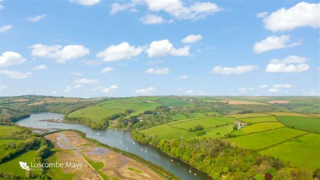
- Breathtaking views across the River Avon and the tidal estuary
- Range of Stone Barns and Modern Farm Buildings
- Offered for sale as a whole or in up to 2 lots to suit purchasers requirements
- Lot 1 – 79.92 acres (32.32 hectares)
- Lot 2 – 10.15 acres (4.10 hectares)
- Offering the potential to create an iconic property in an unrivalled location
Description
DIRECTIONS
From Aveton Gifford, proceed along the tidal road towards Bigbury. Approximately half a mile along this road turn off to the right which will lead into the driveway leading up to Pond Farm.
What3Words Location: picked.operating.trip
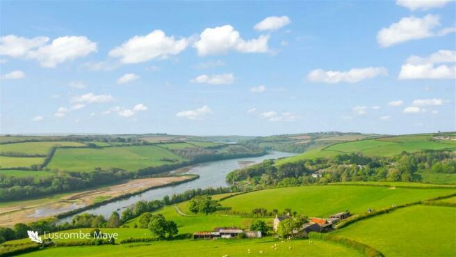
SITUATION
Pond Farm is situated near the village of Aveton Gifford, between the villages of Aveton Gifford and Bigbury, in the South Hams area of South Devon and within an area designated as a National Landscape (formerly known as Area of Outstanding Natural Beauty).
The nearest town of Kingsbridge is about 4 miles away, the city of Plymouth some 15 miles to the west and the A38 dual carriageway expressway, connecting to the M5 motorway and national road network, being about 10 miles to the north.
DESCRIPTION
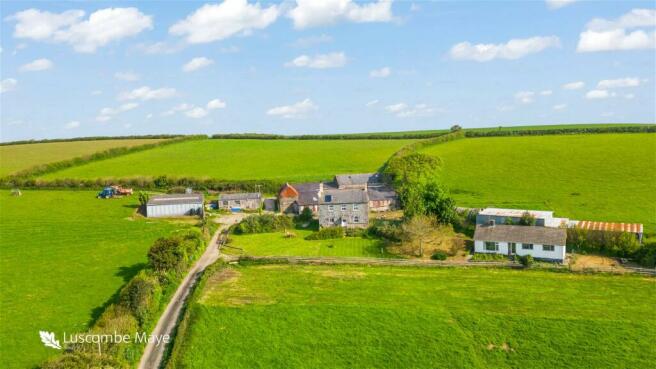
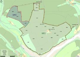
Pond Farm comprises a residential and livestock farm, to include a farmhouse, detached bungalow, range of traditional and modern farm buildings and some 90.07 acres of agricultural land, the full extent of which is as approximately outlined in red on the site plan.
The farm has been divided into two lots (as can be seen from the site plan) and buyers are invited to submit offers on one or both lots as may suit their requirements.
The principal access to the farm is gained off the council maintained tidal road, between the villages of Aveton Gifford and Bigbury. Access is restricted to particular hours of the day based on tidal movement.
There are two alternative accesses to Pond Farm. Firstly, an alternative access may be gained over the public byway Drunkards Lane into field parcel 3555. The second alternative access to the farm may be gained via a Right of Way over Waterhead Lane to a gateway on the eastern boundary of field number 7925 however this is not currently in use. Both alternative access points are labelled and approximately shown by a brown hatched line on the site plan.
LOT 1 - Farmhouse, bungalow, stone and modern farm buildings and agricultural land, extending to 79.92 acres in all (outlined in green on the site plan)
Farmhouse
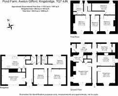
Not of listed status, the farmhouse is believed to have been constructed in 1830, built mainly of rendered solid stone walls with parts being slate hung and under a slate roof. The property comprises the following accommodation:-
Ground Floor
Entrance Hall, Sitting Room, Dining Room, Kitchen, Rear Entrance Porch, Boot Room/Store, Utility Room, Separate WC
First Floor
Landing, Family Bathroom, 4 Bedrooms
Services
Mains water, electric and private septic tank drainage. Solar panel on roof heats water for bathroom and utility room. Meters for the water supply can be identified on site plan by the letter M.
Pond Cottage (Bungalow)
A detached bungalow of Woolaway construction, built in approximately 1965/66 with an interlocking concrete tile roof. This property is subject to an Agricultural Tie whereby only those persons previously or currently working full time in agriculture or forestry are permitted to reside in the dwelling.
The property comprises the following accommodation:-
Entrance Hall, Sitting Room, Kitchen/ Dining Room, Separate WC, Bathroom, 3 Bedrooms, Rear Entrance Porch
Services
Mains water (on the same meter as the farmhouse), electric and private septic tank drainage (both separate from the farmhouse). Economy 7 electric tariff by night for the water heater and night storage heaters.
Stone Barns
Extending to a total area of some 296 square metres (3,186 square feet) over two floors, the stone barns do not have planning consent for change of use to residential but offer the potential for such change of use either as full residential units or as holiday ancillary use. These may be summarised as follows:-
- The Barn – Internal 14.25m x 5m over 2 floors (142 square metres)
- The Stable – Internal 6.85m x 5.25m over 2 floors (71.93 square metres)
- The Coal Store – External 9m x 4.6m over 2 floors (82.8 square metres)
Modern Farm Buildings
Within close proximity of the farmhouse (and partly amongst and linked to the stone barns) is a range of modern farm buildings, extending to a total area of some 614 square metres (6609 square feet). Brief details of which are as follows:-
- Lean-to Cattle Yard – 21.30m x 12.2m (259.86 square metres)
- Nissan Hut (Workshop) – 10.82m x 5.10m (55.19 square metres)
- Woodstore / Sheep shed – 14.82m x 6.07m (89.96 square metres)
- Lambing shed – 12.80m x 5.18m (66.30 square metres) to include overhang
- Cow Shed & Dairy – external overall 10.10m x 5.25m (53.03 square metres)
- Fog Den – external 12.0m x 7.55m (90.60 square metres)
The Lands
The full extent of the land for this lot amounts to some 79.92 acres (32.32 hectares).
The land wraps around the farmhouse and buildings providing a significant amount of protection from other properties.
The land in the past has been used for livestock grazing and grass conservation purposes but offers the potential for other uses subject to obtaining the necessary consents.
The land to the east and south side is served by a well water supply. There are three wells located on the land, of which one is currently in use. The approximate locations are marked on the site plan. The remaining water troughs within close proximity to the house & buildings are fed by the mains supply that also serves the farmhouse.
A schedule of Lot 1 is set out below :-
Field Number Acres Hectares Description
SX6846 3884 2.20 0.89 Woodland
SX6847 1112 0.35 0.14 Woodland
SX6847 7308 2.13 0.86 Woodland
SX6846 4292 5.50 2.22 Permanent Pasture
SX6847 1722 5.09 2.06 Permanent Pasture
SX6847 2103 6.40 2.59 Rough Grassland/scrub
SX6847 3109 5.40 2.18 Permanent Pasture
SX6847 3126 6.28 2.54 Permanent Pasture
SX6847 3240 7.02 2.84 Permanent Pasture
SX6847 4111 8.62 3.49 Permanent Pasture
SX6847 4727 2.87 1.16 Permanent Pasture
SX6847 5809 7.76 3.14 Permanent Pasture
SX6847 7925 4.77 1.93 Permanent Pasture
SX6847 5923 3.16 1.28 Permanent Pasture
SX6847 5320 0.10 0.04 Permanent Pasture
SX6847 6115 0.74 0.30 Permanent Pasture
SX6847 6513 0.21 0.08 Fruit trees/ garden
SX6847 7119 4.74 1.92 Permanent Pasture
SX6847 3555 5.41 2.19 Permanent Pasture
- 1.17 0.47 House, Curtilage, Buildings, Driveway
Total 79.92 32.32
LOT 2 – Land Part Pond Farm (10.15 acres) (hatched in blue on the site plan)
This lot comprises 10.15 acres (4.10 hectares) of land located on the west side of the farm.
Access to the land may be gained off Drunkards Hill public byway which runs along the north boundary and is highlighted by the brown hatched line on the site plan. This access would be suitable for 4x4 vehicles.
This lot includes a pole barn which measures approximately 12.80m x 4.90m (62.72 square metres), this having been used in the past for storage of fodder and/or farm machinery.
There is a separate metered water supply that serves this lot, and the approximate location of the meter is marked on the plan by the letter M. A schedule of Lot 2 is set out below:-
Field Number Acres Hectares Description
SX6846 9551 4.83 1.95 Permanent Pasture
SX6847 0544 3.61 1.46 Permanent Pasture
SX6847 1532 1.71 0.69 Permanent Pasture
Total 10.15 4.10
PUBLIC FOOTPATHS
Public footpaths proceed through part of the farm along the south-west boundary and along the northern end of field parcel 3555. The routes of the footpaths are labelled and approximately shown on the site plan by means of a purple line.
BOUNDARY OWNERSHIP
TENURE
The property is held on a freehold basis with vacant possession being available on legal completion.
SPORTING AND MINERAL RIGHTS
ENVIRONMENTAL STEWARDSHIP SCHEME AGREEMENTS
LOCAL AUTHORITY & COUNCIL TAX
South Hams District Council, Follaton House, Plymouth Road, Totnes, Devon TQ9 5NE.
Pond Farm falls within Council Tax Band C and the amount payable for 2023/24 is £2,106.40.
Pond Cottage falls within Council Tax Band A and the amount payable for 2023/24 is £1,579.81.
EPC
Pond Farmhouse has an EPC rating F with potential for C.
Pond Cottage (Bungalow) has an EPC rating of F also with potential for C.
The full EPC ratings are available on the listing.
GUIDE PRICES
Lot 1 £1,250,000
Lot 2 £100,000
Whole £1,350,000
METHOD OF SALE
The property is being offered for sale by Informal Tender (unless sold prior), such that buyers are invited to submit their highest and final offers in a sealed envelope by Thursday 4th July 2024 at 12 noon. Tender forms are available on request from the Sole Selling Agent.
All tenders must be submitted to 62 Fore Street, Kingsbridge, TQ7 1PP in an envelope clearly marked ‘Pond Farm, Aveton Gifford’.
The seller does not undertake to accept the highest or any of the offers and the seller reserves the right to withdraw, alter or amend the way in which the land is offered for sale.
Buyer(s) will be required to exchange contracts within four weeks of their solicitor receiving a draft contract.
VIEWINGS
Strictly by appointment with the Sole Selling Agents, Luscombe Maye of 62 Fore Street, Kingsbridge, TQ7 1PP. Telephone for details.
HEALTH & SAFETY
Brochures
Brochure 1Council TaxA payment made to your local authority in order to pay for local services like schools, libraries, and refuse collection. The amount you pay depends on the value of the property.Read more about council tax in our glossary page.
Band: C
Aveton Gifford, Kingsbridge

NEAREST STATIONS
Distances are straight line measurements from the centre of the postcode- Ivybridge Station6.3 miles

About the agent
Luscombe Maye Farms & Land, Kingsbridge
62 Fore Street Kingsbridge TQ7 1PP
Well known for handling the sale of farms, land, woodland and smallholdings Luscombe Maye has unrivalled experience in marketing this type of property in the West Country.
Our intimate knowledge of the area and understanding this type of property helps us achieve the maximum interest and therefore most importantly the maximum price for the asset.
We offer a no-obligation pre market appraisal and valuation service for the asset you are consideri
Notes
Staying secure when looking for property
Ensure you're up to date with our latest advice on how to avoid fraud or scams when looking for property online.
Visit our security centre to find out moreDisclaimer - Property reference S950215. The information displayed about this property comprises a property advertisement. Rightmove.co.uk makes no warranty as to the accuracy or completeness of the advertisement or any linked or associated information, and Rightmove has no control over the content. This property advertisement does not constitute property particulars. The information is provided and maintained by Luscombe Maye Farms & Land, Kingsbridge. Please contact the selling agent or developer directly to obtain any information which may be available under the terms of The Energy Performance of Buildings (Certificates and Inspections) (England and Wales) Regulations 2007 or the Home Report if in relation to a residential property in Scotland.
*This is the average speed from the provider with the fastest broadband package available at this postcode. The average speed displayed is based on the download speeds of at least 50% of customers at peak time (8pm to 10pm). Fibre/cable services at the postcode are subject to availability and may differ between properties within a postcode. Speeds can be affected by a range of technical and environmental factors. The speed at the property may be lower than that listed above. You can check the estimated speed and confirm availability to a property prior to purchasing on the broadband provider's website. Providers may increase charges. The information is provided and maintained by Decision Technologies Limited. **This is indicative only and based on a 2-person household with multiple devices and simultaneous usage. Broadband performance is affected by multiple factors including number of occupants and devices, simultaneous usage, router range etc. For more information speak to your broadband provider.
Map data ©OpenStreetMap contributors.