
Land At Junction of Church Street and High Street, Tilbrook, PE28
- PROPERTY TYPE
Land
- SIZE
174,240 sq ft
16,187 sq m
Key features
- 4 Acres Of Paddock Land
- Village Location
- Grade 3 Agricultural Land
- Suitable For Variety Of Uses (STP)
Description
Land At Junction Of Church Lane And High Street Tilbrook
Location and Description
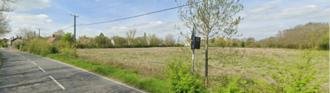
The Land is located in the Village of Tilbrook some 15.5 km south of west of Huntingdon railway station on the road between Raunds, some 9 km northwest of the land and St Neots railway station, some 14.4 km southeast of the land, immediately to the east of Church Lane and north of the B645, High Street. The village of Tilbrook is in the valley of the River Til, which flows into the River Kim to the west of Kimbolton.
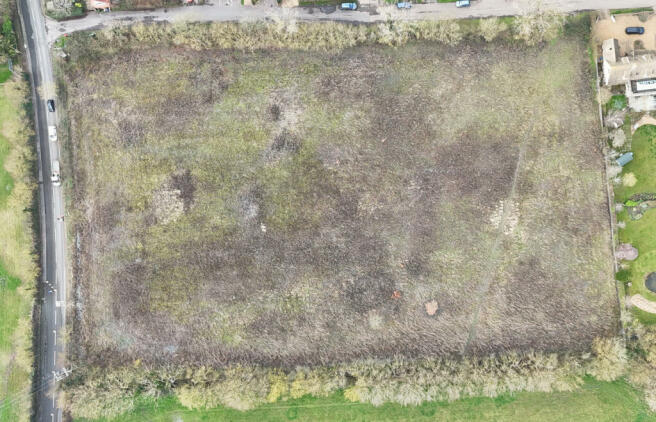
The Land is centred on National Grid Reference TL 0792 6903, at an elevation of approximately 40 m above Ordnance Datum. The Land is broadly rectangular in shape. The site was formerly used for agricultural purposes and is currently disused and overgrown but retains an open agricultural character. The land, although slightly sloping, is relatively level, and is bounded by fencing, hedges, and trees. The ground slopes away to the north of the church, towards the River Till to the north, which marks the lowest lying point of the valley.
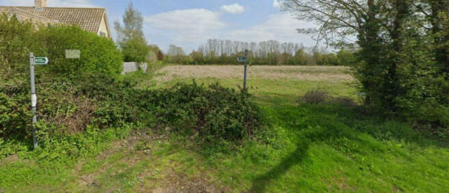
With the village the land is located on the south-east edge of the settlement of Tilbrook. It is bordered to the west by Church Lane, frontage residential development on its western side on Church Lane, separated by a narrow road, to the south by the High street (B645), to the east by open fields and to the north again by residential properties and Church of All Saints approximately 100m or so in the distance.
The B645 has a 30 mph speed limit adjacent to the application site. This historic core of the village is designated as the Tilbrook Conservation Area. The site is located at the southern end of this conservation area. The Church of All Saints is a Grade I Listed Building and lies approximately 100m to the north separated from the land by two residential properties. There is a bus stop located approximately 60m form the land. A footpath connects the bus stop and the village to the Land and a public footpath (number 235/9) runs diagonally across the field in the northern part of the site.
The land area amounts to approximately 1.2 hectares and is field. It is. It is bordered by hedges to three sides.
SITE APPRAISAL
The land is accessed via an entrance in its north-western corner. There is a further access point in the eastern boundary where the public footpath bisects the site in the northern part of the field. The field is currently overgrown, level and bounded by tall hedges/ trees to the east and west. Immediately to the north of the site is a residential dwelling with gardens running its length. The wider area is partly residential in character, with several houses and other village buildings existing.
• The Land lies wholly within the Tilbrook Conservation Area and is south of All Saints Church, a Grade I Listed Building.
• A Public Right of Way footpath in the northern part of the field runs from the northeast to the southwest but lies outside of the location map red line plan.
• The land is classified as Grade 3 agricultural land, falling within the categories that are considered the best and most versatile agricultural land.
• The land lies within Flood Zone 1 as identified on the Environment Agency's flood risk maps and Huntingdonshire's Strategic Flood Risk Assessment 2017.
PLANNING HISTORY HUNTINGDONSHIRE DISTRICT COUNCIL
Planning Applications (4)
Development of 7 dwellings.
Ref. No: 20/70099/PENQ | Status: Withdrawn
Rural exceptions housing development of 7 new dwellings.
Ref. No: 22/01332/FUL | Status: Withdrawn
Erection of a farm shop, restaurant, and plant centre
Ref. No: 22/01459/FUL | Status: Withdrawn
Rural exceptions housing development of 7 new dwellings.
Ref. No: 23/01069/FUL | Status: Refused
Planning Appeals (0)
Properties (0)
Building Control Applications (0)
Licensing (0)
Licensing Application (0)
ACCESS
The site is accessed directly off the High Street.
RIGHTS, EASEMENTS AND RESTRICTIONS
The land is sold subject to and with the benefit of all public rights and private rights of way, light drainage, overhead cable, and other easements and restrictions or obligations that exist whether the same are describe in the particulars.
Viewing
By appointment only.
HEALTH AND SAFETY
Given the potential hazards on site we ask you to be as vigilant as possible when viewing the plot. Neither the seller or the agent are accountable for the safety of those viewing the plot and accordingly those viewing the plot, do so at their own risk and must be accompanied unless from a public view point.
GUIDE PRICE
Guide Price: £165,000 for the freehold.
LOCAL AUTHORITY
Huntingdonshire District Council, Pathfinder House, St Mary's Street,
Huntingdon, PE29 3TN. T: .
BOUNDARIES
The buyer will be deemed to have inspected the property and satisfied themselves as to the ownership of any boundaries.
Land At Junction of Church Street and High Street, Tilbrook, PE28

NEAREST STATIONS
Distances are straight line measurements from the centre of the postcode- St. Neots Station9.0 miles

About the agent
Annafield Estate Agents & Property Management, Huntingdon
103 High Street, Huntingdon, PE29 3LL
A local estate agency, run by experienced, local people, dealing with all aspects of selling and lettings in St.Neots, Buckden, Huntingdon and the surrounding area.
Industry affiliations

Notes
Disclaimer - Property reference RX368605. The information displayed about this property comprises a property advertisement. Rightmove.co.uk makes no warranty as to the accuracy or completeness of the advertisement or any linked or associated information, and Rightmove has no control over the content. This property advertisement does not constitute property particulars. The information is provided and maintained by Annafield Estate Agents & Property Management, Huntingdon. Please contact the selling agent or developer directly to obtain any information which may be available under the terms of The Energy Performance of Buildings (Certificates and Inspections) (England and Wales) Regulations 2007 or the Home Report if in relation to a residential property in Scotland.
Map data ©OpenStreetMap contributors.