Southfield Lane & Withernsea Road, Tunstall, Hull
- PROPERTY TYPE
Land
- SIZE
Ask agent
Key features
- Versatile Block of Agricultural Land
- c.46.75 acres (18.98 hectares)
- Good Road Frontage
- Grade III Classification
- Available by Private Treaty
Description
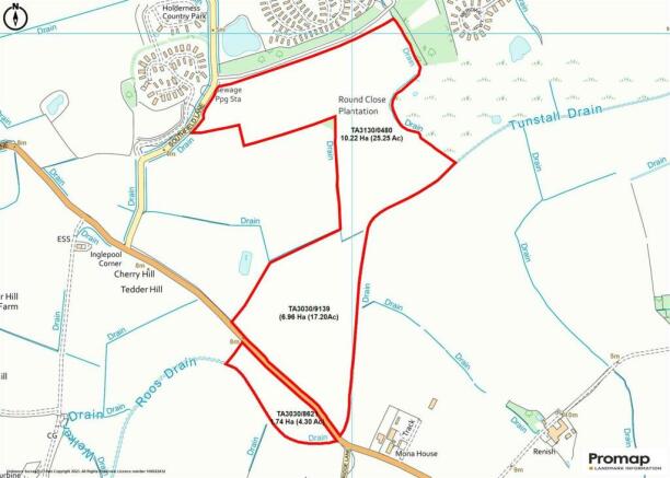
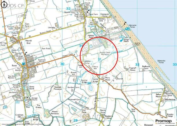
Location - The property is located at Tunstall, a coastal village in the district of Holderness, lying approximately 3 miles north of the coastal resort town of Withernsea. The land has both frontage and access from Southfield Lane and the B1242 Withernsea Road. The land fringes the Sand Le Mere holiday park at Tunstall
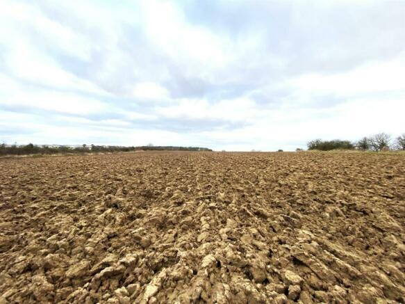
Description - The property comprises a block of productive agricultural land in two blocks straddling the B1242 Withernsea Road and in total extending to 46.75 acres (18.98 hectares) thereabouts. The main block lies to the north of the B1242 is in two land parcels and extends to 42.45 acres (17.18 hectares). The land block south of the B1242 extends to 4.30 acres (1.74 hectares). The land has previously been sown down to temporary grass leys, but has now reverted back into an arable rotation.
Land Classification & Soil Type - The land undulates and is fringed by a series of drains and hedge boundaries, having being sown to a temporary grass, but previously has been in arable cropping. The land is shown as being classified as being Grade III under the Agricultural Land Classification (ALC) maps, with the soil type being within the 'Holderness' association with the ancillary sub-group being 'Burlingham', suitable for growing cereals and short term grassland.
Designations - The land is located within a Nitrate Vulnerable Zone (NVZ)
Rural Payments Agency & Environmental Schemes - The land has been registered with the Rural Payments Agency (RPA) for the Basic Payment Scheme. The land is not known to be included in any Environmental Scheme.
Sporting & Mineral Rights - The sporting rights are included in the sale, together with the mineral rights so far as these are owned.
Wayleaves, Easements & Rights Of Way - The land is sold subject to and with the benefits of all rights of way, water, drainage, watercourses and other easements and rights of adjoining property owners affecting the same and all existing and proposed wayleaves and other matters registered by any competent authority subject to statute.
There is a wayleave in favour of Northern Powergid crossing part of the land. Further details are available upon request.
There are no known rights of way or public footpaths affecting the land.
Drainage & Outgoings - There is believed to be underdrainage in part within the northern block of land, albeit no drainage plans have been made available. There is a small drainage rate payable to South Holdernss Drainage Board, further details are available upon request.
Contaminated Land - The vendors and their agents are not aware of any of the land being filled with any contaminated matter referred to in the Environmental Protection Act 1990, however you should satisfy yourself on this aspect.
Method Of Sale - The land is offered for sale by Private Treaty, with best offers sought over £400,000
Tenure & Possession - The land is sold freehold with vacant possession, following expiry of a one year Farm Business Tenancy expiring 8th October 2024 or earlier by agreement.
Overage - The land is offered for sale subject to an overage/development uplift clause but will only relate to the land parcel north of the B1242.
If the use of the land is changed from agricultural, either through planning consent or permitted development rights (under the General Development Consent Order) then an 'uplift' (overage) would be payable to the vendors or their successors in title. This will be based upon 30% of the increase in Market Value of the property immediately before planning consent was granted (excluding hope value) and the Market Value of the property immediately after planning consent is granted but taking into account the terms of any such consent granted. The overage/ development uplift will run for 30 years from the date of completion.
Valuations & Deductions - There will be no ingoing valuation to pay and the purchaser shall not make any claim for deductions or dilapidations of any kind what so ever.
Plans & Measurements - Any plans forming part of these particulars are included for identification purposes and do not form part of the contract for sale. Areas or measurements were stated are those taken from the Rural Land Register (RLR) and are given as a guide only and should be checked by you or your own agent(s).
What3words - Access to each of the land parcels can be found at:-
TA3130/0480 - ///intelligible.appraised.skewing
TA3030/9139 - ///silently.damp.porridge
TA3030/8621 - ///finalists.rectangular.frown
Planning - Planning enquiries in respect of the property should all be directed to East Riding of Yorkshire Council, County Hall, Beverley, East Riding of Yorkshire, HU17 9BA. Web
Viewings - There are a number of access points to the land, which are specifically given above under What3Words, which are visible from both Southfield Land and the B1242 Withernsea Road. Viewings should be undertaken during daylight hours.
Health & Safety - Please take care when accessing/egressing from the land with frontage to the Withernsea Road
Sole Agents - Leonards, 512 Holderness Road, Hull HU9 3DS. Tel: , Email: , Ref: MJB/RMB
Brochures
Southfield Lane & Withernsea Road, Tunstall, HullBrochureSouthfield Lane & Withernsea Road, Tunstall, Hull

NEAREST STATIONS
Distances are straight line measurements from the centre of the postcode- New Clee Station13.0 miles
About the agent
Leonards, Hull
512 Holderness Road, Hull, HU9 3DS
LEONARDS Est. 1884
……professionals in the town and countryside
Leonards are a progressive independent firm of Chartered Surveyors and Estate Agents having been founded 1884 to become firmly established as a mixed practice, providing professional property advice and services to both the rural and urban needs of the City of Kingston Upon Hull, the East Riding of Yorkshire and North Lincolnshire.
The firm is proud of combining the virtues and experience of a traditional Charter
Notes
Disclaimer - Property reference 32823339. The information displayed about this property comprises a property advertisement. Rightmove.co.uk makes no warranty as to the accuracy or completeness of the advertisement or any linked or associated information, and Rightmove has no control over the content. This property advertisement does not constitute property particulars. The information is provided and maintained by Leonards, Hull. Please contact the selling agent or developer directly to obtain any information which may be available under the terms of The Energy Performance of Buildings (Certificates and Inspections) (England and Wales) Regulations 2007 or the Home Report if in relation to a residential property in Scotland.
Map data ©OpenStreetMap contributors.