Land At A5, Watling Street, Towcester, NN12
- SIZE AVAILABLE
871,200 sq ft
80,937 sq m
- SECTOR
Land for sale
Key features
- 20 acres of mixed use land
- Lake with two islands previously used for commercial fishing
- Abundance of wildlife
- Former garden centre
- Scope for redevelopment
- The property is being offered for sale as a whole.
- Shrub land, formally pasture, suitable for grazing a small amount of cattle
- Tree lined driveway from the Towcester Road
- 20 acres (8.13 hectares)
Description
Description
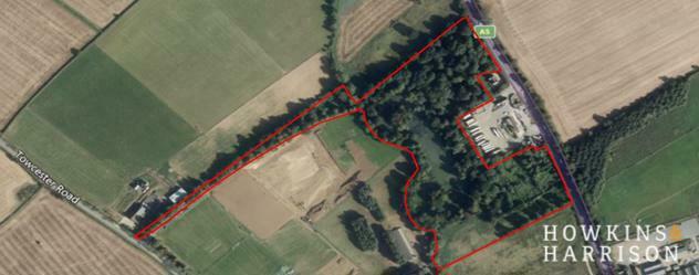
The property extends to approximately 20 acres (8.13 hectares) comprising a range of components including a mixed species woodland including yew, horse chestnut, cedar, oak and beech, providing a tree lined driveway from Towcester Road.
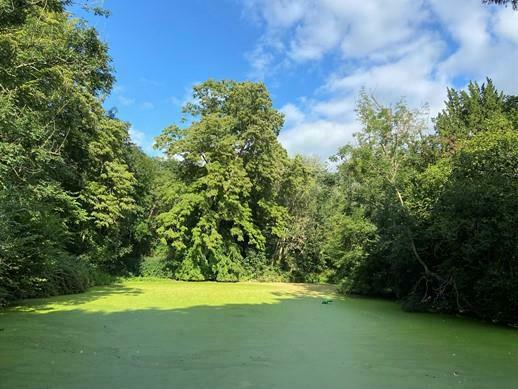
The site also comprises a lake with two islands which was previously been used for commercial fishing, hosting an abundance of wildlife including waterfowl giving indication of the lake's stock levels and health. An outlet flows into a stream situated on the western boundary to accommodate heavy rainfall.
To the southeast of the property lies a former garden centre with a walled garden, now disused, with access on to the A5, providing scope for redevelopment, subject to obtaining requisite planning permission.
The southern area of the property provides an open area of shrub land, formerly pasture, suitable for grazing a small number of sheep or cattle.
On the southern boundary is a telephone mast let to Vodafone for a period of ten years from 2019.
Description Acres
Woodland 10.979
Lake 3.932
Former Garden Centre 2.150
Pasture/Scrub 2.908
Telephone Mast 0.031
Total 20
Boundaries and Fencing
The purchaser will erect and maintain a boundary fence at the point of transfer to delineate the boundary prior to commencement of development.
Lotting
The property is being offered for sale as a whole. The vendor reserves the right to offer the property for sale in any order other than that described in these particulars, to sub-divide, amalgamate or withdraw the property from sale without prior notice.
Plan, Area and Description
The plan, area and description are believed to be correct in every way, but no claim will be entertained by the vendor or their agents in respect of any error, omissions or misdescription. The plan is for identification purposes only.
Rights of Way
There are overhead cables crossing the land, servicing the telecoms mast and neighbouring properties at South Lodge. We are not aware of any other rights of way, easements or wayleaves over the land.
Location
The land is situated off the A5, just north of Towcester, with secondary access from Towcester Road to the south. To the north, the A5 gives access to Daventry (10 miles) and Towcester to the south; benefiting from the Towcester bypass which links with the M1 south of Northampton (6 miles). To the north is Silverstone (5 miles), Bicester (20 miles) and the M40 (15 miles) heading south.
Further along the A5 past Towcester is Milton Keynes (13 miles).
Overage
The previous owners imposed an overage on the sale of the land based on 40% of the uplift in value from any development from historic etc use being a plant nursery/garden centre for a period of 21 years.
Price
The property will be offered for sale by private treaty.
Utilities
Mains water and electricity are believed to be available nearby. It should be noted that it is the responsibility of a potential purchaser to make their own enquiries to the appropriate authorities as to the location and availability of mains services.
Planning
The property is situated to the north of Towcester and is considered to have some long-term development potential with some scope for redevelopment of buildings on the land subject to obtaining the necessary planning permissions. Consent has been granted on the opposite side of the A5 for 'B8' industrial use.
West Northamptonshire Council
Tel.
Development.
Viewings
At any reasonable time during daylight hours with the sale brochure to hand.
Contact the Commercial Department.
Brochures
Land At A5, Watling Street, Towcester, NN12
NEAREST STATIONS
Distances are straight line measurements from the centre of the postcode- Northampton Station7.6 miles
Notes
Disclaimer - Property reference 2221FH. The information displayed about this property comprises a property advertisement. Rightmove.co.uk makes no warranty as to the accuracy or completeness of the advertisement or any linked or associated information, and Rightmove has no control over the content. This property advertisement does not constitute property particulars. The information is provided and maintained by Howkins & Harrison, Rugby. Please contact the selling agent or developer directly to obtain any information which may be available under the terms of The Energy Performance of Buildings (Certificates and Inspections) (England and Wales) Regulations 2007 or the Home Report if in relation to a residential property in Scotland.
Map data ©OpenStreetMap contributors.


