Residential Development Land, Newport
- PROPERTY TYPE
Residential Development
- SIZE
Ask agent
Description
* 15 Units have been allocated within the LDP of which 50% are to be Affordable Houses. The site within the LDP extends to 0.5 Hectares - 1.24 Acres or thereabouts is situated within a registered Historic Landscape and there is to be an express requirement for a Detailed Scheme within any Planning Application.
* The site has Dormouse activity nearby and on that basis a Buffer Zone will be required.
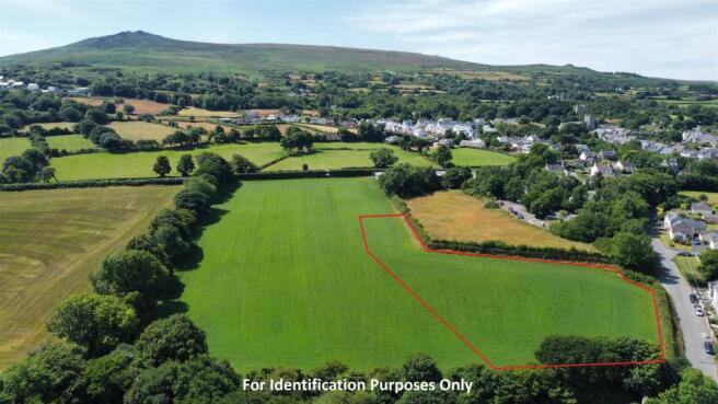
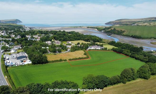
* A Pre Application has been made for the Development of 26 Dwellings which include the Areas of Land within the LDP and are also Land outside the Settlement Limits. The Land boundary extend to 2.4 Acres or thereabouts is edged red on the Aerial Photographs.
N.B. The Vendor owns the entirety of the Field which in total extends to 7.25 Acres or thereabouts. Rarely do Development Sites of this nature appear on the 'Open Market' and the opportunity to purchase should not be missed. Early Inspection Strongly Advised.
Situation - Newport is a popular Market Town which stands on the North Pembrokeshire Coastline between the Market Towns of Fishguard (7 miles west) and Cardigan (11 miles north east).
Newport has the benefit of a good range of Shops, a Post Office, Primary School, Church, Chapels, Public Houses, Restaurants, Hotels, Cafes, Takeaways, Art Galleries, a Memorial/Community Hall, Tourist Information Centre, a Health Centre and Dental Surgery.
The Pembrokeshire Coastline at The Parrog is within half a mile or so of the Property and also close by are the other well known sandy beaches and coves at Newport Sands, Ceibwr Bay, Poppit Sands, Aber Rhigian, Aberfforest, Cwm-yr-Eglwys, Pwllgwaelod and Aberbach. The 18 Hole Links Golf Course at Newport Sands is within 2 miles by road.
Newport stands within the Pembrokeshire Coast National Park which is designated an area of Outstanding Natural Beauty and protected accordingly.
Carningli Mountain and Common being close by, provide excellent Walking, Rambling, Hacking and Pony Trekking facilities.
The well known Market Town of Cardigan is within easy car driving distance and has the benefit of an good Shopping Centre together with a wide range of amenities and facilities including Secondary and Primary Schools, Churches, Chapels, Banks, Building Societies, Hotels, Restaurants, Public Houses, Cafes, Take-Away's, Art Galleries, a Cinema/Theatre, Supermarkets, Petrol Filling Stations, a Further Education College and a Cottage Hospital.
The County and Market Town of Haverfordwest is some 20 miles or so south and has the benefit of an excellent Shopping Centre together with an extensive range of amenities and facilities including The County Council Offices and The County Hospital at Withybush.
There are good road links along the Main A40 from Fishguard to Haverfordwest and Carmarthen and the M4 to Cardiff and London as well as good rail links from both Fishguard and Haverfordwest to Carmarthen, Cardiff, London Paddington and the rest of the UK. There is also a regular Bus Service along the Main A487 Road west to Fishguard, south to Haverfordwest and north east to Cardigan and Aberaeron.
Feidr Pen-Bont is the Newport to Moylgrove Coast Road which runs in a North Easterly direction off the Main A487 Fishguard to Cardigan Road. The site concerned is situated within 400 yards or so Newport Town Centre and the Shops at Market Street and Long Street.
Directions - From Fishguard take the Main A487 Road East for some 7 miles and in the Town of Newport take the 5th turning on the left (a short distance past The Golden Lion Public House) signposted to Moylgrove and Newport Sands. Continue on this road for 200 yards or so and the site concerned is a short distance past the turning into Feidr Pen-y-Bont Business Park. A 'For Sale' Board is erected at the roadside entrance.
Alternatively from Cardigan take the Main A487 Road South West for some 11 miles or so and upon entering the Town of Newport take the first turning on the right signposted to Molygrove and Newport Sands. Follow directions as above.
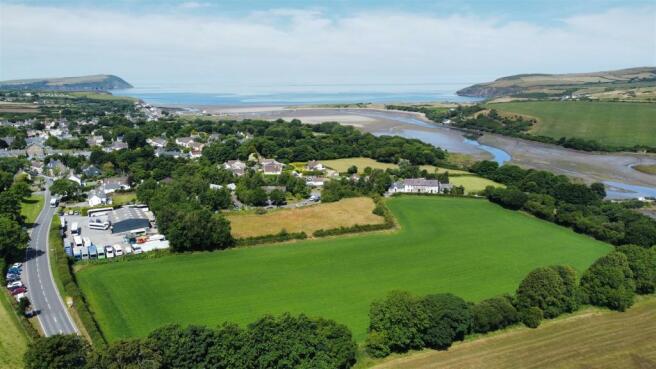
Description - The Land concerned is a Prime Residential Development Site which is situated on the edge of this popular Coastal Town within the Pembrokeshire Coast National Park. The Site is in the main situated within the settlement limits for the Town and has a initial allocation of 15 Dwellings. The area of Land allocated within the LDP extends to 0.5 Hectares - 1.24 Acres or thereabouts.
The site that is edged in red on the Aerial Photo extends to 2.40 Acres or thereabouts in total which is the area of Land submitted in the Pre Application and is situated on the eastern fringes of the Town with frontage and access onto Feidr Pen-y-Bont. The Site itself is within 200 yards or so of the Main A487 Road and is within 400 yards or so of the centre of the popular Coastal Town of Newport.
The site is currently utilised for Agricultural purposes and in total the field extends to 7.25 Acres or thereabouts. The Land is gently sloping with a northerly aspect and the southern boundary of the field abuts onto the Main A487 Fishguard to Cardigan Road. The extent of Land that is being offered 'For Sale' at the quoted Price Guide is approximately 2.40 Acres or thereabouts and is bounded in red on the Aerial Photographs. N.B. The boundaries of the Land on the Aerial Photographs is for Identification purposes only.
Planning - A pre-application has been made for the development of 26 Dwellings which includes the areas of the Site both within and outside the settlement limits as defined by the LDP. The area of Land within the LDP extends to 0.5 Hectares - 1.24 Acres or thereabouts.
The Full Application is available within the Technical Pack and feedback is summarised below:-
15 Units have been allocated within the LDP. At this stage there is reluctance to increase the number or permit development outside of that part of the site, which is not within the LDP.
Of the 15 Units which have been allocated for the site, 50% have to be Affordable Houses.
Dormouse Activity - The site has Dormouse activity nearby so a Buffer Zone will be required.
Historic Landscape - As the site is within the registered Historic Landscape (Conservation Area), there is likely to be an expressed requirement for a Detailed Scheme within any Planning Application).
Tenure - The entire Property is of Freehold Tenure with Vacant Possession upon Completion.
Terms - Pricing structure of the Transaction can be discussed in detail upon application with Joint Selling Agents (see below for details).
Technical Pack - Technical Pack is available to interested Parties once a formal expression of interest has been received.
Vat And Legal Costs - Any prices are quoted are exclusive of VAT.
Each Party will be responsible for their own Legal Costs incurred in any transaction. Prospective Purchasers should satisfy themselves as to whether or not VAT will apply to the transaction.
Further Details available from the Joint Selling Agents:-
BP2 Property Consultants
Urban Village, 221 High Street, Swansea, SA1 1NW.
Roger Poolman FRICS -
or
David Blyth MIRCS -
or
J.J. Morris, 21 West Street, Fishguard, Pembrokeshire, SA65 9AL - Arwel Thomas FNAEA or .
Brochures
Residential Development Land, NewportBrochureResidential Development Land, Newport
NEAREST STATIONS
Distances are straight line measurements from the centre of the postcode- Fishguard Harbour Station6.8 miles
Notes
Disclaimer - Property reference 31739348. The information displayed about this property comprises a property advertisement. Rightmove.co.uk makes no warranty as to the accuracy or completeness of the advertisement or any linked or associated information, and Rightmove has no control over the content. This property advertisement does not constitute property particulars. The information is provided and maintained by JJ Morris, Fishguard. Please contact the selling agent or developer directly to obtain any information which may be available under the terms of The Energy Performance of Buildings (Certificates and Inspections) (England and Wales) Regulations 2007 or the Home Report if in relation to a residential property in Scotland.
Map data ©OpenStreetMap contributors.


