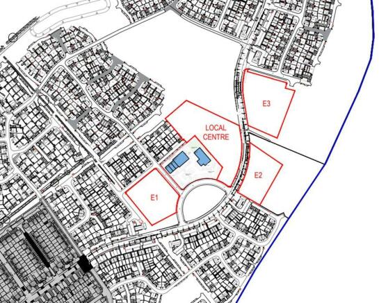
Sites E1, E2 And E3 Airfield Way, Weldon, Corby, Northamptonshire, NN17 3LX
- SIZE AVAILABLE
50,094-192,535 sq ft
4,654-17,887 sq m
- SECTOR
Land for sale
Key features
- Development site suitable for B1 of the Town and Country Planning (Use Classes) Order 1987 as amended.
- Three individual sites; 1.15 acres, 1.39 acres and 1.88 acres (0.47ha, 0.56ha and 0.76ha).
- Not more than 3,450 sqm (37,135 sqft) of floor space to be provided for uses within Use Class B1 associated with the local centre under planning application no: 09/00083/OUT.
- Offered with vacant possession.
- N/A
- The sites are available freehold with vacant possession. Offers are invited either as a whole or as 3 separate lots. For further details contact he agents.
Description
Site E1 totals approximately 0.56 hectares (1.39 acres) and will be situated next to the local centre.
Unit E2 is situated on the other side of the road, a short distance away totalling 0.47 hectares (1.15 acres) and next door is site E3 totalling 0.76 hectares (1.88 acres) - all accessed directly off Airfield Way that leads to the A43.
Brochures
Sites E1, E2 And E3 Airfield Way, Weldon, Corby, Northamptonshire, NN17 3LX
NEAREST STATIONS
Distances are straight line measurements from the centre of the postcode- Corby Station2.7 miles
Notes
Disclaimer - Property reference 3012106FH. The information displayed about this property comprises a property advertisement. Rightmove.co.uk makes no warranty as to the accuracy or completeness of the advertisement or any linked or associated information, and Rightmove has no control over the content. This property advertisement does not constitute property particulars. The information is provided and maintained by Eddisons Commercial Limited, Kettering. Please contact the selling agent or developer directly to obtain any information which may be available under the terms of The Energy Performance of Buildings (Certificates and Inspections) (England and Wales) Regulations 2007 or the Home Report if in relation to a residential property in Scotland.
Map data ©OpenStreetMap contributors.


