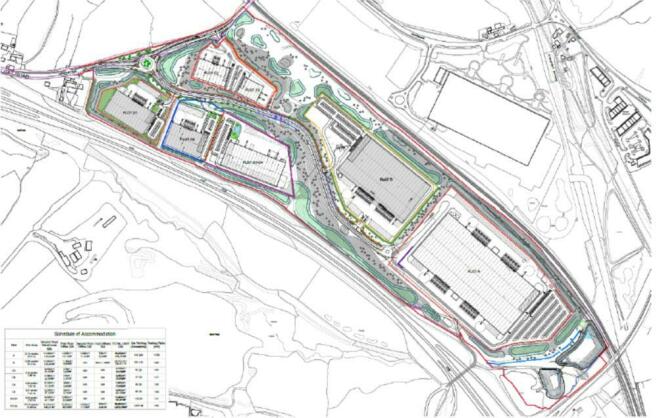
Chatterley Park, Staffordshire
- SIZE AVAILABLE
23,500-580,000 sq ft
2,183-53,884 sq m
- SECTOR
Industrial park for sale
Description
The site, extends to 106 acres, and has detailed planning allowing for 1.2 million sq ft of industrial and logistics floorspace, including the potential for a large unit of up to 650,000 sq ft. It also benefits from a live rail siding to the West Coast Mainline.
Master-planned for maximum flexibility, Chatterley Park has a space to match any requirement. Spec build options range from small to mid-box opportunities in a range of sizes ideal for any occupier seeking a Grade-A upgrade.
Key Points
- Outline planning permission for 1.2 million sq. ft of B/B8 space employment
- Can accommodate a single building of 590,000 sq. ft
- Leasehold & Freehold BTS
- Unrestricted Eaves heights
- 10.5 MVA available
- Enterprise Zone status
Location Description
Located on the axis of the A500 and M6 in Newcastle-under-Lyme, Staffordshire The Chatterley Park site sits adjacent to the A500 just 4 miles from Junction 16 of the M6.
Brochures
Chatterley Park, Staffordshire
NEAREST STATIONS
Distances are straight line measurements from the centre of the postcode- Kidsgrove Station1.6 miles
- Longport Station1.9 miles
- Alsager Station3.0 miles
Notes
Disclaimer - Property reference 82140_232UDL00. The information displayed about this property comprises a property advertisement. Rightmove.co.uk makes no warranty as to the accuracy or completeness of the advertisement or any linked or associated information, and Rightmove has no control over the content. This property advertisement does not constitute property particulars. The information is provided and maintained by Cushman & Wakefield LLP, London & South East - Industrial. Please contact the selling agent or developer directly to obtain any information which may be available under the terms of The Energy Performance of Buildings (Certificates and Inspections) (England and Wales) Regulations 2007 or the Home Report if in relation to a residential property in Scotland.
Map data ©OpenStreetMap contributors.


