Marhamchurch, Bude, Cornwall, EX23
- PROPERTY TYPE
Land
- SIZE
401,188 sq ft
37,272 sq m
Description
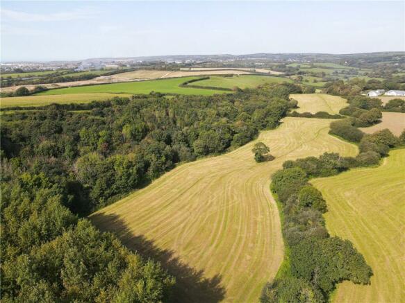
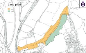
• Lot 1 - Approximately 16.24 acres comprising an attractive parcel of young broadleaf woodland, a dedicated parking area, as well as a small parcel of land situated immediately north of the parking area - Guide Price: £190,000
• Lot 2 - Approximately 9.21 acres consisting of two level riverside pasture fields, as well as a small copse of mature poplar trees - Guide Price: £150,000
THE PROPERTY
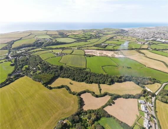
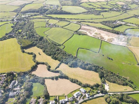
Hele Valley Woodland (lot 1) extends to approximately 16.24 acres in total and comprises an attractive parcel of young broadleaf woodland, a dedicated parking area, as well as a small parcel of land situated immediately north of the parking area. Throughout the woodland are several well-established paths and walking routes. The main access to the woodland is from the eastern end, directly from Pinch Hill via an established gateway which in turn leads to the hardcore parking area. Lot 1 also benefits from additional access from the western boundary.
The woodland is part of the Hele Valley Trail and was established with the help and support of a number of local organisations and government organisations, as noted on various signposts and information boards which are located around the site.
Lot 2 measures approximately 9.21 acres and consists of two level riverside pasture fields as well as a small copse of mature poplar trees to the south-west. Lot 2 shares the access from the eastern end of lot 1 over the parking area.
LOCATION
The land is situated on the outskirts of the attractive village of Marhamchurch and lies approximately 1.5 miles south of the seaside town of Bude which offers a range of amenities. The land could be used as a base from which to explore all the North Cornish Coast has to offer, including its beaches, coastal walks and trails which enable easy access to the National Cycle Network. The A39 ‘Atlantic Highway’ is less than half a mile away and provides a great access link south leading further down into Cornwall and north leading out of Cornwall and into Devon.
METHOD OF SALE
The property is offered for sale by private treaty.
TENURE & POSSESSION
Freehold with vacant possession upon completion.
BASIC PAYMENT SCHEME
No entitlements are included with the sale.
WOODLAND GRANT SCHEME
Both Hele Valley Woodland (lot 1) as well as the Poplar copse which forms part of lot 2 were established under a Farm Woodland Premium Scheme (FWPS) agreement. The incoming purchaser agrees to comply with the obligations of this agreement and maintain the woodland in accordance with the terms of the FWPS contract for the remaining period until the end of 2033. Further details are available from the agents upon request.
SERVICES
No services are currently connected to the land, although given its proximity to residential properties and the public highway; it is likely that services could be connected in the future. Interested parties should satisfy themselves regarding this.
WAYLEAVES, EASEMENTS & RIGHTS OF WAY
A public footpath runs from north to south over a section of lot 1 as shown on the definitive right of way map. The current vendor will retain an easement for a water meter and pipe that runs under the woodland and serves further land that they will be retaining. Lot 2 will benefit from a right of vehicular access over the parking area included within lot 1 to the bridge which leads into lot 2.
HEALTH & SAFETY
Interested parties are requested to take particular care when inspecting the land. Potential purchasers should wear supportive footwear for viewings and are advised to be conscious of potentially uneven and slippery surfaces.
SPORTING, TIMBER & MINERAL RIGHTS
Included, insofar as they are able to be.
LOCAL AUTHORITY
Cornwall Council
New County Hall, Treyew Road, Truro, Cornwall, TR1 3AY
VIEWINGS
Interested parties can view the land and woodland at their own convenience, subject to prior arrangement with the agents.
DIRECTIONS
From Bude, briefly proceed south along the A39 for approximately 150 metres before turning left onto Pinch Hill, signposted Marhamchurch and Week St Mary. Proceed along this road for approximately 600 metres and immediately after passing the 30mph signs, the entrance to the land/car park area can be found on your right-hand side, where a for sale board has been erected.
WHAT3WORDS
/// rattler.confident.rally
Brochures
ParticularsMarhamchurch, Bude, Cornwall, EX23
NEAREST STATIONS
Distances are straight line measurements from the centre of the postcode- Okehampton Station23.8 miles
Established in 1855 Carter Jonas is a leading UK property consultancy specialising in Residential, Rural, Commercial and Planning and Development. With 34 offices across the country, including nine in central London and an exclusive affiliation with Christie’s International Real estate offering coverage across over 50 countries, Carter Jonas is best placed to sell, let, or manage your property to a wealth of buyers and tenants.
Established in 1855 Carter Jonas is a leading UK property consultancy specialising in Residential, Rural, Commercial and Planning and Development. With 34 offices across the country, including nine in central London and an exclusive affiliation with Christie’s International Real estate offering coverage across over 50 countries, Carter Jonas is best placed to sell, let, or manage your property to a wealth of buyers and tenants.
Notes
Disclaimer - Property reference TRU230019. The information displayed about this property comprises a property advertisement. Rightmove.co.uk makes no warranty as to the accuracy or completeness of the advertisement or any linked or associated information, and Rightmove has no control over the content. This property advertisement does not constitute property particulars. The information is provided and maintained by Carter Jonas Rural, Truro. Please contact the selling agent or developer directly to obtain any information which may be available under the terms of The Energy Performance of Buildings (Certificates and Inspections) (England and Wales) Regulations 2007 or the Home Report if in relation to a residential property in Scotland.
Map data ©OpenStreetMap contributors.


