Coombe Lane, Brighstone, Newport
- SIZE AVAILABLE
1,325,095 sq ft
123,105 sq m
- SECTOR
Land for sale
Key features
- Attractive block of land
- Approximately 30.42 acres (12.31 ha).
- Attractive package
- Sporting potential
- Natural capital and offsetting opportunities
- South facing position
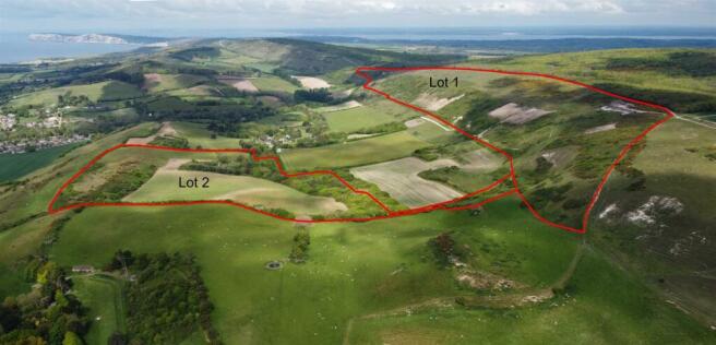
- Available as a whole or in two separate lots
Description
Description - This is a rare opportunity to acquire a block of land with the flexibility to support a livestock farming system and enhance natural capital assets or forestry opportunities.
Lot 2 extends to approximately 30.41 acres, consisting of pasture, arable and woodland with access from Coombe Lane via a permitted access over the retained track. There is potential to manage the land uses
for Biodiversity Net Gain, Natural Capital, Carbon Offsetting or Re-wilding purposes, subject to necessary consents. The Isle of Wight is a designated Biosphere.
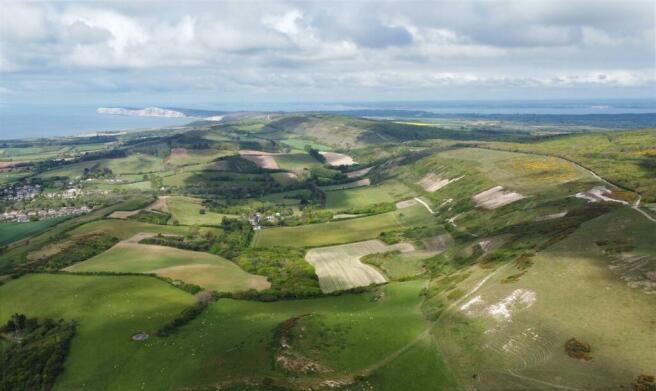
Situation - The land at Brighstone Down is situated in an idyllic spot in the west of the Isle of Wight, with views to the south across open countryside to the English Channel. It is located on the outskirts of the village of Brighstone and is less than 7 miles from the harbour town of Yarmouth which has regular car/ passenger ferry connections to Lymington with onward rail connections from Lymington Harbour (London Waterloo 2 hours 5 minutes).
Yarmouth offers a wide range of facilities including yacht clubs, marina, pubs, restaurants and shops. The village of Brighstone is closer still with shops, pub and school.
The land is situated within National Landscapes (AONB) and has a public footpaths crossing the property. The land has been used in a mixed arable and livestock farming system with a focus on nature conservation.
General Remarks And Stipulations -
Method Of Sale - The property is offered for sale by private treaty
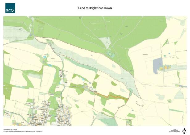
Access And Public Rights Of Way - Lot 2 - The land is accessed from Coombe Lane and then with an access right over the retained track coloured orange on the sale plan. Lot 2 has connecting access to Lot 1 if purchased together.
Wayleaves & Easements - The property is sold subject to and with the benefits of all rights, including rights of way, whether public or private, light, support, drainage, water and electricity supplies and any other rights and obligations, easements and proposed wayleaves for masts, pylons, stays, cables, drains and water, gas and any other pipes, whether referred to or not.
Services - Lot 2 - No services are connected to Lot 2.
Tenure & Possession - The land is currently subject to a grazing licence ending in October 2024 which can be terminated earlier if required. The property will be sold freehold with vacant possession
Designations - The land is situated in an Natural Landscapes (AONB) and Nitrate Vulnerable Zone.
Local Authority - Isle of Wight
Sporting, Mineral And Timber Rights - The sporting, mineral and timber rights are in-hand and are included in the sale of the freehold insofar as they are owned. The land has been part of a successful high-quality shoot as part of a wider holding. The sporting rights will be retained by the vendor free of charge until 2nd February 2025.
Basic Payment History - There is no Basic Payment History to be transferred to the purchaser.
Covenants To Be Applied - 1. The purchaser will erect and maintain a stock proof fence along the southern boundary between points C and D on the sales plan. Such fence to be erected with 6 months of completion of the sale.
2. The use of the sale land will be restricted to agricultural and nature conservation use.
3. Tree planting will be restricted to native tree species and coniferous trees cannot be planted.
Existing Covenants - No residential buildings can be constructed on the land. No buildings permitted except agricultural buildings.
What3words - ///scanty.swaps.honeybees
Brochures
Coombe Lane, Brighstone, Newport
NEAREST STATIONS
Distances are straight line measurements from the centre of the postcode- Lymington Pier Station9.3 miles
Notes
Disclaimer - Property reference 33065102. The information displayed about this property comprises a property advertisement. Rightmove.co.uk makes no warranty as to the accuracy or completeness of the advertisement or any linked or associated information, and Rightmove has no control over the content. This property advertisement does not constitute property particulars. The information is provided and maintained by BCM Wilson Hill, Isle of Wight. Please contact the selling agent or developer directly to obtain any information which may be available under the terms of The Energy Performance of Buildings (Certificates and Inspections) (England and Wales) Regulations 2007 or the Home Report if in relation to a residential property in Scotland.
Map data ©OpenStreetMap contributors.


