Communisis House, Manston Lane, Leeds, LS15 8AH
- SIZE AVAILABLE
226,370 sq ft
21,030 sq m
- SECTOR
Warehouse for sale
Key features
- 21,030 sq m (226,370 sq ft) freehold industrial facility
- Secure site of approximately 4.23 hectares (10.44 acres)
- Well positioned for access to the M1, M62 and A1 motorways
- Substantial power of around 3 megawatts available
- Suitable for owner occupation or subdivision, subject to the usual consents
Description
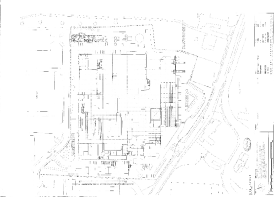
Having been adapted and extended over the years, the property provides mostly interconnected accommodation and offers generous car parking provision and good access and circulation space for HGV’s.
The property is prominently positioned fronting Manston Lane which is around 0.5 miles west of the A6120 Manston Lane roundabout / East Leeds Orbital Route (ELOR) which leads to the M1 motorway (J46).
The immediate surroundings including other industrial occupiers including Longs of Leeds and Sound Leisure Ltd. Thorpe Park office park and The Springs retail and leisure park are only minutes from the property.
Brochures
Communisis House, Manston Lane, Leeds, LS15 8AH
NEAREST STATIONS
Distances are straight line measurements from the centre of the postcode- Cross Gates Station0.9 miles
- Garforth Station2.0 miles
- East Garforth Station2.5 miles
Notes
Disclaimer - Property reference 216973-1. The information displayed about this property comprises a property advertisement. Rightmove.co.uk makes no warranty as to the accuracy or completeness of the advertisement or any linked or associated information, and Rightmove has no control over the content. This property advertisement does not constitute property particulars. The information is provided and maintained by Sanderson Weatherall, Leeds. Please contact the selling agent or developer directly to obtain any information which may be available under the terms of The Energy Performance of Buildings (Certificates and Inspections) (England and Wales) Regulations 2007 or the Home Report if in relation to a residential property in Scotland.
Map data ©OpenStreetMap contributors.


