Former Anhydrite Mine, Haverton Hill Road, Billingham, TS23 1QZ
- SIZE AVAILABLE
260,486 sq ft
24,200 sq m
- SECTOR
Commercial property for sale
Key features
- Volume of mine totalling 11,500,000m3 and covering 400 hectares
- Lapsed planning consent for 4,000,000m3 of storage of APCr
- Site at ground level totalling 2.42 hectares
- Stable mine structure and non-reactive environment
- Two shafts with a 3.5 metre diameter
- Located near to existing industrial premises including EfW facility
- Well located with good access to A1(M) via the A19 and A66
Description
Development Opportunity - 6 acre surface area, also 11 Million cubic metre void underground.
Anhydrite was mined here from 1921 until 1971 with over 33,000,000 tonnes being extracted principally to make fertilisers and cements. The mine is accessed from two shafts some 230 metres in depth, surrounded by a site of 2.42 hectares (5.54 acres) at ground level.
The mine offers potential for various storage uses including, but not limited to, waste materials such as APCr and other residues in a non-reactive environment. Anhydrite was mined here from 1921 until 1971 with over 33,000,000 tonnes being extracted principally to make fertilisers and cements. The mine is accessed from two shafts some 230 metres in depth, surrounded by a site of 2.42 hectares (5.54 acres) at ground level.
The mine offers potential for various storage uses including, but not limited to, waste materials such as APCr and other residues in a non-reactive environment.
Location
Billingham has excellent access to the A19, providing access north to Sunderland and Newcastle, and south to York. The A19 also provides access to the A1(M) via the A66, providing access to locations between Edinburgh and London.
Alternative transport north is available by the Durham Coast Rail Line. This line also provides connections to London via the Trans-Pennine rail network at Thornaby.
Teesside International Airport is approximately 12 miles to the west with Newcastle International Airport approximately 42 miles to the north. The town also lies approximately 5 miles from Tees Port and benefits from excellent access to the other North East coastal ports via the A19.
Specifications
For specification details, please speak to one of our agents.
Other Information
Introduction
Anhydrite was mined here from 1921 until 1971 with over 33,000,000 tonnes being extracted principally to make fertilisers and cements. The mine is accessed from two shafts some 230 metres in depth, surrounded by a site of 2.42 hectares (5.54 acres) at ground level.
The mine offers potential for various storage uses including, but not limited to, waste materials such as APCr and other residues in a non-reactive environment.
Location
The mine is located on the north bank of the River Tees and to the south east of Billingham town centre. The shafts providing entry to the mine are accessed from Haverton Hill Road via a right of way.
Billingham has excellent access to the A19, providing access north to Sunderland and Newcastle, and south to York. The A19 also provides access to the A1(M) via the A66, providing access to locations between Edinburgh and London.
Alternative transport north is available by the Durham Coast Rail Line. This line also provides connections to London via the Trans-Pennine rail network at Thornaby.
Teesside International Airport is approximately 12 miles to the west with Newcastle International Airport approximately 42 miles to the north. The town also lies approximately 5 miles from Tees Port and benefits from excellent access to the other North East coastal ports via the A19.
Description
The mine extends over a distance of approximately 1.5 kms east to west and 3 kms north to south with a total footprint of around 400 hectares (988.42 acres) and a volume (excluding pillars) of approximately 11,500,000m3.
The depth of the mine workings vary from 130 metres in the north, dropping by roughly 80 metres per mile, to 260 metres in the south. The ambient mine temperature is 15¡c.
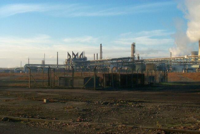
The site at ground level is generally level with a gradual slope from north west to south east. The site comprises an open area and fenced compound containing two covered shafts. The shafts are located 27 metres apart, with a 3.5 metre internal diameter. There are currently no winding gears in place.
There are private sidings situated adjacent to the ground level site. This offers the potential for discussions to be had with the adjacent land owner to negotiate access to these sidings, providing for an alternative route for material import to the property.
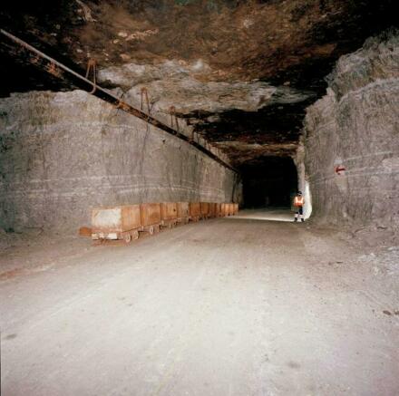
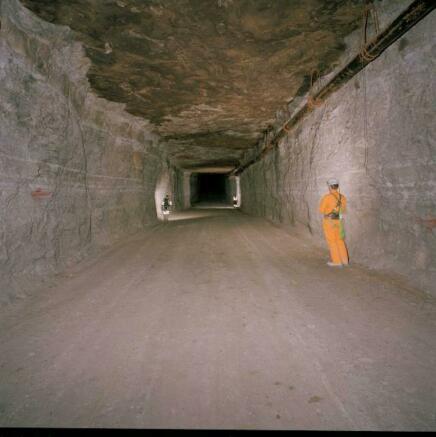
Below ground, the mine comprises a series of rooms and pillars with a ratio of room volume to room and pillar volume of approximately 55% and a typical roof height of 5 metres. The shaft top works have been removed and the shafts covered with removable caps.
Condition
The room and pillar construction, together with the natural strength of the rock, has resulted in a stable mine structure on one level.
Planning
Permission was granted on 13th April 2011 for the conversion of the mine to a 4,000,000m3 waste storage facility. The application has since lapsed but allowed for storage of APCr, comprising of a hazardous waste, together with office, laboratory, treatment facility and winding gear for the shafts.
For advice on alternative proposals, purchasers should approach Stockton-on-Tees Borough Council planning department.
Additional information
Agents can provide access to an online data room for further details on the property, including planning history.
Tenure
The site is held freehold under Land Registry Title number CE188479. Freehold is being offered with vacant possession.
Terms
Guide price Ð Inviting offers.
Legal Costs
Each party is to be responsible for their own legal costs incurred in the transaction.
VAT
VAT, if applicable, will be charged at the standard rate.
Brochures
Former Anhydrite Mine, Haverton Hill Road, Billingham, TS23 1QZ
NEAREST STATIONS
Distances are straight line measurements from the centre of the postcode- Billingham Station0.9 miles
- Middlesbrough Station1.7 miles
- Stockton Station3.0 miles
Notes
Disclaimer - Property reference 109053-1. The information displayed about this property comprises a property advertisement. Rightmove.co.uk makes no warranty as to the accuracy or completeness of the advertisement or any linked or associated information, and Rightmove has no control over the content. This property advertisement does not constitute property particulars. The information is provided and maintained by Avison Young (UK) Limited, Minerals, Waste and Energy. Please contact the selling agent or developer directly to obtain any information which may be available under the terms of The Energy Performance of Buildings (Certificates and Inspections) (England and Wales) Regulations 2007 or the Home Report if in relation to a residential property in Scotland.
Map data ©OpenStreetMap contributors.


