Land and Buildings at Upwood Airfield, Ramsey, Huntingdonshire
- PROPERTY TYPE
Farm Land
- SIZE
Ask agent
Description
In all about 135.76 ACRES (54.95 hectares)
FOR SALE AS A WHOLE
SITUATION
The Land at Upwood Airfield is located to the north of the village of Upwood, in the county of Huntingdonshire. The airfield was originally used during the First World War as a Home Defence Landing, after the land was requisitioned from the former Lord de Ramsey in 1917. The RAF continued to use the airfield as a bomber station until the end of the Second World War, and it was later used as a training centre for squadrons, before reverting to farmland in 1972.
The property is situated to the south-west of the attractive market town of Ramsey, which benefits from a thriving community, as well as being home to a variety of local amenities including two primary schools, a range of public houses and restaurants, a supermarket, doctor´s surgery and leisure centre. The property is approximately 11 miles from the centre of Huntingdon, on the banks of the river Great Ouse, where there are a wide variety of places to eat and drink, as well as being home to independent shops, historic heritage sites and Huntingdon Racecourse. The cathedral city of Peterborough is situated approximately 14 miles to the north, and is well known for its thriving theatre and city centre.
The property benefits from good road links and is approximately 10 miles from Junction 15 of the A1 (M) to the west, which leads to the Fletton Parkway Interchange to the north, and links to the A605 to the east and west, providing connections to local towns and villages. Junction 21 of the A14 lies to the south of the property and can be reached in under half an hour by car, which provides excellent dual carriageway links to the M11 at Cambridge to the east and the M1/M6 to the west. Peterborough train station, situated approximately 14 miles away, offers direct trains to London Kings Cross in under 50 minutes on the East Coast Mainline, together with direct trains to Cambridge, Stansted Airport and Birmingham.
GENERAL
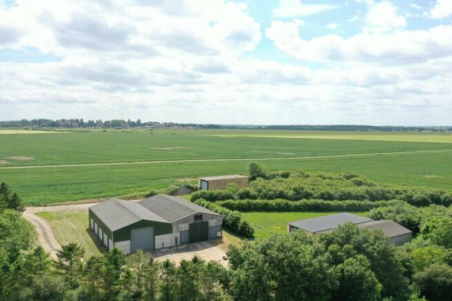
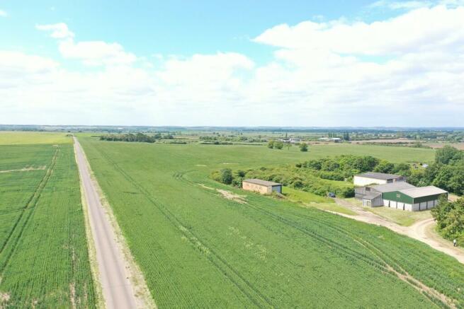
The property presents an exciting opportunity to purchase approximately 135.76 acres (54.95 hectares) of predominantly commercial arable land together with a useful range of buildings and extensive concrete yard, and areas of spinney and grassland. The comprehensively under-drained arable land has grown combinable crops in recent years and the current owners have also grown onions and potatoes. Some of the buildings benefit from a three-phase electricity supply and a mains water supply. The property can be accessed over a well-maintained track, known as Rose Street and also described as the ´Airfield Through Road´, leading from Longholme/Upwood Road to the west or alternatively from Biggin Lane in Ramsey.
The property extends to approximately 121.65 acres (49.23 hectares) of arable land and approximately 3.81 acres (1.54 hectares) of woodland according to the Rural Land Register, together with approximately 10.30 acres (4.18 hectares) comprising of grass areas, the buildings, yard and tracks according to the Ordnance Survey Map.
ARABLE LAND
The arable land comprises approximately 121.65 acres (49.23 hectares) of level, productive fields in a ring fence, which are bordered by further agricultural land together with a ground mounted solar scheme to the east. The land has been well farmed in an arable rotation with combinable crops in recent years, and has historically grown onions and potatoes during the 1980´s. Many of the fields have been comprehensively under drained and copies of the drainage plans are available from the Selling Agent. The land is Grade 2 according to the Land Classification Maps of England and Wales. The soil is identified as being of the Cannamore soil association according to the Soil Survey of England and Wales, which can be described as fine loamy over clayey and clayey soils with slowly permeable subsoils.
BUILDINGS AND YARD
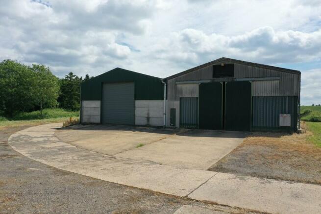
The property benefits from a range of useful farm buildings, which have predominately been used for grain and commodity storage in conjunction with the farming enterprise. They may be suitable for alternative uses, subject to obtaining the necessary planning consents. There are concrete aprons to the front of the buildings and an extensive yard area, which provides additional general storage. The buildings include a number of old bomb stores historically used as part of the former RAF airfield, together with modern farm buildings erected by the current owners.
GENERAL INFORMATION
Method of Sale
The property is offered for sale by Private Treaty as a Whole.
Tenure and Possession
The property is offered freehold with vacant possession upon completion.
Sporting, Timber and Mineral Rights
All sporting, timber and mineral rights are included in the freehold sale, insofar as they are owned.
Drainage
The plans of the comprehensive under drainage schemes are included within the Information Pack.
Countryside and Environmental Stewardship
The property is not currently subject to any Countryside Stewardship Schemes or Environmental agreements.
Local Authority
Huntingdonshire District Council
Services
There is a three-phase electricity and water supply to the building complex.
Overage
The Sellers will retain 40% of any uplift in value if planning permission is obtained for a development or change of use of the land from agricultural use during the first 30 years after completion of the sale. The overage payment will be triggered upon disposal of land with the benefit of planning permission or implementation of planning permission.
Easements, Wayleaves, Covenants and Rights of Way
The property is sold subject to and with the benefit of all existing wayleaves, easements and rights of way, whether public or private, light, sport, drainage, water, electricity supplies and any other rights, obligations, easements and quasi easements, whether specifically mentioned or not.
More specifically, the property can be accessed over a well-maintained track, known as Rose Street and the ´Airfield Through Road´, leading from Longholme/Upwood Road to the west or alternatively via a shared right of way along this track with access from Biggin Lane in Ramsey. The property has a number of rights of way over the access track off Longholme/Upwood Road for the benefit of adjoining land owners. The cost of repair and maintenance of the track is shared as a percentage of the total acreage owned by the adjacent land owners, having the benefit of similar rights of way. There is a right of way over the track for the benefit of the old sewerage works, to the north west of Grid Reference TL2684 1813. More detailed information is available from the Selling Agent upon request.
A public footpath adjoins the northern boundary.
VAT
Should the sale of the property or rights attached to the sale become a chargeable supply for the purpose of VAT, such tax will be paid by the Purchaser(s) in addition to the purchase price.
Boundaries
The Purchaser(s) will be deemed to have inspected the property and satisfied themselves as to the ownership of any boundary, hedge, tree or ditch.
Plans, Areas and Schedules
Plans included or attached to these particulars are based upon the Ordnance Survey Maps copyright reserved and ). All plans are not to scale.
Viewings
All viewings are strictly by appointment only through the seller´s agent, Bletsoes.
Navigation: PE26 2RY (nearest postcode)
what3words (off Biggin Lane): ///songbook.agent.vertical
what3words (off Longholme/Upwood Road): ///uptown.busy.shadowing
Health and Safety
Given the potential hazards of a working farm, we ask you to be as vigilant as possible when making your inspection, for your own personal safety, particularly around farm buildings and machinery.
Ingoing Valuation
In addition to the purchase price the purchaser will be required to pay for: Growing crops and all beneficial cultivations, subsoiling, mole ploughing and acts of husbandry since the last harvest at current CAAV rates or contract rates where applicable. Seed, fertilisers, manures and sprays applied to the growing crops since the last harvest will be recharged at invoice cost. Lime and chalk applied since the last harvest at invoice cost of the materials and spreading.
Measurements and Other Information
All measurements are approximate. While we endeavour to make our Sales Particulars accurate and reliable if there is a point which is of particular importance please do contact Bletsoes who will be pleased to check the information for you, particularly if you are contemplating travelling some distance to view the property.
Brochures
BrochureLand and Buildings at Upwood Airfield, Ramsey, Huntingdonshire
NEAREST STATIONS
Distances are straight line measurements from the centre of the postcode- Whittlesea Station7.4 miles
Notes
Disclaimer - Property reference 100064003298. The information displayed about this property comprises a property advertisement. Rightmove.co.uk makes no warranty as to the accuracy or completeness of the advertisement or any linked or associated information, and Rightmove has no control over the content. This property advertisement does not constitute property particulars. The information is provided and maintained by Bletsoes, Thrapston. Please contact the selling agent or developer directly to obtain any information which may be available under the terms of The Energy Performance of Buildings (Certificates and Inspections) (England and Wales) Regulations 2007 or the Home Report if in relation to a residential property in Scotland.
Map data ©OpenStreetMap contributors.


