Lime Kiln Wood, Lindale, Grange-Over- Sands, Cumbria
- PROPERTY TYPE
Land
- SIZE
551,470 sq ft
51,233 sq m
Key features
- Mature, native woodland designated as Ancient Semi-Natural Woodland.
- High in biodiversity with a rich mix of flora and fauna.
- Conveniently located close to the village of Lindale and Grange-over-Sands.
- Benefitting from roadside access.
- An historic Lime Kiln is located within the heart of the woodland.
- Located on the edge of the Lake District National Park [UNESCO World Heritage Site].
Description
Particulars
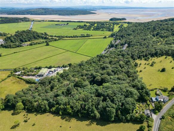
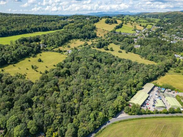
to approximately 12.66 acres [5.12 hectares], situated on an east-facing limestone escarpment between Lindale and Grange over Sands.
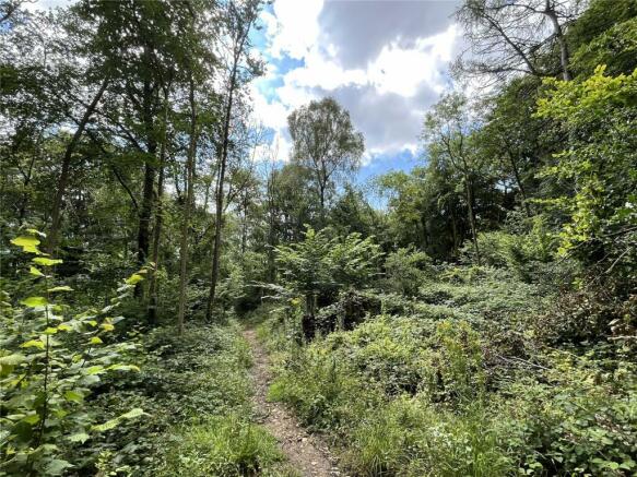
It is designated as Ancient Semi-Natural Woodland (ASNW) and comprises a variety of broadleaf species including Oak, Ash, Yew, Beech, Sycamore, Downy Birch and Hazel. This delightful woodland offers a variety of habitat and a wealth of flora and fauna, including bluebells and woodland bird species.
The woodland is privately owned by a Trust and has been managed primarily for the purposes of conservation and quiet enjoyment. A woodland management plan has been in place over recent years and the woodland has been actively managed to boost biodiversity, including thinning and coppicing of hazel. Further details are available on the Trust’s website
The woodland rises from the roadside to offer views of the surrounding countryside and across to Morecambe Bay. Boundaries consist primarily of dry-stone walls and are generally in good condition. There is vehicular access via a gateway directly off the B5277 (Lindale Road).
Within the heart of the woodland lies a former Lime Kiln, used during the Victorian age to process locally quarried limestone into lime. The structure of the Lime Kiln was carefully stabilised and restored by the current owners in 2018.
Directions
From the A590 and Lindale Roundabout, take the exit signposted Meathop, Lindale, Grange. Follow this road (B5277) for approximately 1.5 miles into Lindale village. At the roundabout in the centre of the village, turn left to continue along the B5277 towards Grange-over-Sands. Continue for approximately 0.5 miles, the woodland is located on the right hand side and marked by the selling agents board.
Location
Lime Kiln Wood lies on the southern edge of the delightful village of Lindale, just 1.8 miles north of Grange-over-Sands and 12 miles south of Kendal in the county of Cumbria.
What3Words: Purest.hoped.wires
Grid Reference: SD
Services
Tenure
Freehold. Vacant possession upon completion.
Services
There are no services currently within the woodland.
Boundary Responsibilities
The ownership and maintenance responsibilities of the boundaries are indicated with ‘T’ marks on the sale plan. Where no ‘T’ marks are shown, the responsibilities are unknown.
Designations
Lime Kiln Wood is designation as an Ancient Semi-Natural Woodland.
Part of the woodland is covered by a Limestone Pavement Order.
Schemes
The woodland is not currently under any Stewardship/ Management Schemes. The last Woodland Management Plan ended on 31/12/23.
Sporting and Mineral Rights
Included insofar as we are aware.
Local Planning Authority
Westmorland and Furness Council. Tel No: .
Access
Vehicular access to the woodland is provided directly off the B5277. A public footpath passes through the woodland, and outside the western boundaries. A bridleway adjoins the eastern and northern boundaries.
Sale Plan
The Sales Plan has been prepared by the Selling Agents for the convenience of prospective purchasers. They are deemed to be correct with any error, omission or misstatement shall not affect the sale. The purchasers must satisfy themselves as to its accuracy.
Viewing
Lime Kiln Wood can be viewed at any
reasonable time, provided a copy
of these particulars are in possession.
Enquiries
Email:
Tel No: , Option 3.
Brochures
ParticularsLime Kiln Wood, Lindale, Grange-Over- Sands, Cumbria
NEAREST STATIONS
Distances are straight line measurements from the centre of the postcode- Grange-over-Sands Station1.1 miles
- Arnside Station2.9 miles
- Kents Bank Station2.8 miles

H&H Land & Estates are one of the North's leading independent Estate and Residential Letting Agents with a heritage that gives us a depth of knowledge and experience unrivalled in the local market.
Our dedicated team operates across a vast expanse of stunning locales, spanning Cumbria, Northumberland, County Durham, North Yorkshire, and into North Lancashire. With seven strategically positioned offices in Carlisle, Cockermouth, Durham, Kendal, Northallerton, Penrith and Staveley, we are your local experts, armed with a wealth of experience in the property market.
Exceptional Service, Every Step of the WayAt H&H Land & Estates, we are committed to delivering a level of service that goes above and beyond your expectations. We understand that your property journey is a significant life event, and we're here to ensure it's a smooth and successful one.
Transparent CommunicationWe know how important it is to stay informed throughout your property journey. We know that waiting for updates can be frustrating, which is why we prioritise timely communication. You can expect feedback from viewings within 24 hours, keeping you fully informed about all relevant details related to the sale of your property. We believe in regular contact, providing you with key data on your property's marketing progress and offering expert advice whenever needed
Notes
Disclaimer - Property reference KEN240027. The information displayed about this property comprises a property advertisement. Rightmove.co.uk makes no warranty as to the accuracy or completeness of the advertisement or any linked or associated information, and Rightmove has no control over the content. This property advertisement does not constitute property particulars. The information is provided and maintained by H&H Land & Estates, Penrith. Please contact the selling agent or developer directly to obtain any information which may be available under the terms of The Energy Performance of Buildings (Certificates and Inspections) (England and Wales) Regulations 2007 or the Home Report if in relation to a residential property in Scotland.
Map data ©OpenStreetMap contributors.


