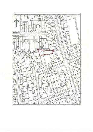
Land Rear Of 28 - 30 Merrill Road, Thurnscoe, Rotherham, South Yorkshire, S63 OPS
Business rates & charges may apply
- SIZE
Ask agent
- SECTOR
Land for sale
Key features
- 0.177 acres (715 sqm)
- Planning Permission Granted for 3 Dwellings
- Close to Local Schools and Facilities
- Planning Reference: 2021/1613
Description
All mains services are understood to be available to the site. Interested parties should make their own enquiries of the service providers.
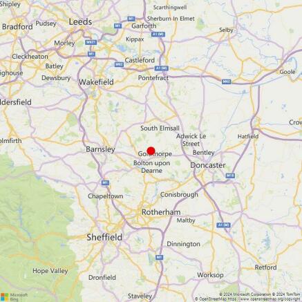
The village of Thurnscoe has a population of approximately 9,133 people and is located in South Yorkshire approximately 7.5 miles to the east of Barnsley, 9 miles to the north or Rotherham and 8.5 miles to the west of Doncaster.
The site is located off Merrill Road within an established housing estate close to Gooseacre Primary School, village centre facilities on Houghton Road and the Thurnscoe Health Centre on Holly Bush Drive.
All prices, premiums and rents etc are quoted exclusive of VAT at the prevailing rate.
N/A
N/A
0.177 acres (715 sqm)
Planning Permission Granted for 3 Dwellings
Close to Local Schools and Facilities
Planning Reference: 2021/1613
Brochures
Land Rear Of 28 - 30 Merrill Road, Thurnscoe, Rotherham, South Yorkshire, S63 OPS

NEAREST STATIONS
Distances are straight line measurements from the centre of the postcode- Thurnscoe Station0.5 miles
- Goldthorpe Station1.1 miles
- Bolton-on-Dearne Station2.2 miles
Notes
Disclaimer - Property reference 3947FH. The information displayed about this property comprises a property advertisement. Rightmove.co.uk makes no warranty as to the accuracy or completeness of the advertisement or any linked or associated information, and Rightmove has no control over the content. This property advertisement does not constitute property particulars. The information is provided and maintained by Smiths Chartered Surveyors, Barnsley. Please contact the selling agent or developer directly to obtain any information which may be available under the terms of The Energy Performance of Buildings (Certificates and Inspections) (England and Wales) Regulations 2007 or the Home Report if in relation to a residential property in Scotland.
Map data ©OpenStreetMap contributors.