
Plot adj 9 Tir Syr Walter, Garnant, Ammanford, SA18
- PROPERTY TYPE
Plot
- SIZE
Ask agent
Key features
- Parcel Of Land
- Quiet Country Road Location
- Application Planning Ref No. E/29427
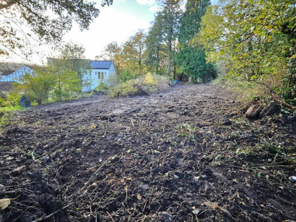
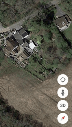
Description
An opportunity has arisen to purchase a parcel of land situated on a country road in the village of Garnant which has nearby access to the riverside walks and cycle paths. Prospective purchasers should make their own enquiries regarding future planning permission, services and connection charges.
The village itself offers excellent leisure facilities and boasts a modern primary school and an 18 hole golf course. The main shopping facilities are located at Ammanford town centre. Access to the M4 motorway would be via junction 49 at Pont Abraham.
Potential Building Plot:
Former application reference number E/29427 dated 9/1/2014 for one dwelling. Prospective purchasers should make their own enquiries regarding new planning application, services and costs involved.
Location:
Situated on a country road in the village of Garnant with nearby access to the riverside walks and cycle paths.
Plot adj 9 Tir Syr Walter, Garnant, Ammanford, SA18

NEAREST STATIONS
Distances are straight line measurements from the centre of the postcode- Ammanford Station4.5 miles
- Pantyffynnon Station4.8 miles
- Llandybie Station4.8 miles
Notes
Disclaimer - Property reference S1053019. The information displayed about this property comprises a property advertisement. Rightmove.co.uk makes no warranty as to the accuracy or completeness of the advertisement or any linked or associated information, and Rightmove has no control over the content. This property advertisement does not constitute property particulars. The information is provided and maintained by Calow Evans, Ammanford. Please contact the selling agent or developer directly to obtain any information which may be available under the terms of The Energy Performance of Buildings (Certificates and Inspections) (England and Wales) Regulations 2007 or the Home Report if in relation to a residential property in Scotland.
Map data ©OpenStreetMap contributors.