Moreleigh, Totnes
- PROPERTY TYPE
Land
- SIZE
Ask agent
Key features
- 16.21 acres (6.56 hectares)
- Meadows and permanent grass
- Natural regeneration broadleaf woodland
- Idyllic secluded valley location
- Natural water supply
- Further lots available
Description
Mileage
Plymouth approx. 22.2 miles, Totnes approx. 6.8 miles, Exeter approx. 34 miles, Dartmouth approx. 9.7 miles, Kingsbridge approx. 7.5 miles, Newton Abbot approx. 15.7 miles. (London Paddington via Totnes Train Station approx. 2.45 hours).
Situation
Nestled at the head of this Devon valley just over a mile from an Area of Outstanding Natural beauty and the River Avon valley. With the Village of Moreleigh within walking distance just 0.8 miles away, with the well-respected New Inn public house, Village Hall and children's recreation ground and historic 13 Century church There is a good community village hall and children's play park. Beyond that is the area of Gara Bridge which is a great valley for walking and wild swimming. The highest pasture fields on the farm enjoy uninterrupted views to Dartmoor and the Coast. The beautiful South Hams coastline is just a short distance away with beaches, golf, boating and country walks all being catered for making Moreleigh and Halwell an excellent location.
Description
Higher Farleigh Farm has been lime rendered and lime washed painted, recently newly fitted double glazed wooden windows with Dimplex quantum electric heaters. The farm has been in the same family ownership for three generations, having been a traditional mixed farm and it is now offered to the market for the first time in over 50 years with a substantial detached farmhouse in an idyllic courtyard setting with a range of stone barns with planning permission to create one residential unit and one Holiday Let. The land is divided into three main areas but is also available in five lots with particularly far-reaching views from the top of the farm towards Dartmoor and the coast. In particular an idyllic setting in Lot 4, offering seclusion and a stream in a leafy valley.
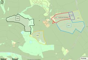
Lot 1 Higher Farleigh Farmhouse and Stone Barns (Identified edged red on Sale Plan)
Description/Accommodation
Entering down the country lane, turning through into a partially stoned entrance into a courtyard setting with a spring running through the courtyard with Stone Linhay and Barns overlooking the courtyard. Stone steps lead to a stone and lime pointed entrance porch with slate seats. Solid wooden door opens into an entrance hall with original door frames and striped wooden doors. Main reception room with inset Morso woodburner, inset window seat with views over the courtyard and countryside beyond. Kitchen with exposed beams, inset Rayburn, sink and drainer with a range of wooden units and a window seat. Useful lean-too utility with plenty of space for additional kitchen units. Reception Room two with a solid wooden floor, slate hearth with a fireplace with wooden surround and mantel with inset Jotul woodburner. Door leading out to a conservatory/sunroom.
Description/Accommodation Continued
The property having two staircases - the first one leading up from the kitchen with a whitewashed staircase with exposed floorboards leading through to the front three principal bedrooms taking in views of the surrounding countryside and Dartmoor. Offering an abundance and historic features throughout with an original fireplace and striped wooden floors. Bathroom with bath, shower over with hand wash basin and W.C. Bedroom Four with rear aspect and rear hall with airing cupboard. The bedroom accommodation has excellent ceiling heights with plenty of natural light throughout.
Kitchen Garden
Situated behind the house there is a kitchen garden with a small greenhouse.
Detached Stone Barns
With the main barn divided into three on the lower level with original stabling to the end. The barns offer a superb opportunity to create additional accommodation and separate dwellings and planning permission for one 3 bed permanent dwelling and one 2 bed holiday let property has been granted (Reference: SB/17/2467/04/F) with planning confirmed live. Curtilage to the rear backing onto the fields. There is a separate access to these barns away from the farmyard. To the bottom of the courtyard there is a Stone Linney and further lean-too. There is a further wooden frame general purpose agricultural/storage barn located to the south-east of the farmhouse adjoining the opposite side of the lane providing additional storage and parking areas.
Land Lot 1 House & Farm Guide £1,075,000 (Identified edged red on Sale Plan)
Extends in total to 8.72 acres (3.53 hectares) and is comprised of 0.81 acres (0.33 hectares) of the house, gardens, buildings and yards and 3 adjoining grassland paddocks which extend to a further 7.91 acres (3.20 hectares). The land is free draining pastureland bordered predominately by solid Devon hedge banks and with the benefit of a mains water supply and access from the adjoining roads/tracks.
Lot 2 Guide £30,000 (Identified edged purple on Sale Plan)
A useful pasture paddock extending to 2.31 acres (0.93 hectares) of permanent pasture with triangular area of tree planting to the south, bordered by solid Devon hedge banks and with the benefit of access directly onto the Farleigh Lane to the north.
Lot 3 Guide £80,000 (Identified edged yellow on Sale Plan)
Two good sized fields extending in total to 6.26 acres (2.53 hectares) bordered by Devon hedge banks and with the benefit of a mains water supply. The land is in an elevated position adjoining the Moreleigh Road with access from Farleigh Lane to the north.
Lot 4 Guide £240,000 (Identified edged blue on Sale Plan)
An excellent block of six fields extending in total to 20.45 acres (8.28 hectares) in an elevated position with far reaching views over the surrounding South Hams countryside towards the southern slopes of Dartmoor. The land is currently sown to grass but capable of arable cropping if required and bordered by solid Devon hedge banks, the majority of which have recently been stock fenced. The land benefits from a mains water supply and benefits from access from the top of the land directly off Farleigh Cross.
Lot 5 Region of £75,000 (Identified edged orange on Sale Plan)
Two fields extending in total to 9.03 acres (3.65 hectares) set in a secluded location to the south-west of the main farm buildings and land and approached via a council maintained track/right of way. The land is currently sown to grass but capable of arable cropping if required. The land is bordered to the south and west by some areas of semi-mature and mature broadleaf tree growth and is watered by the stream that runs across the south/south-western edge of the land.
Lot 6: Region of £110,000 (Identified edged black on Sale Plan)
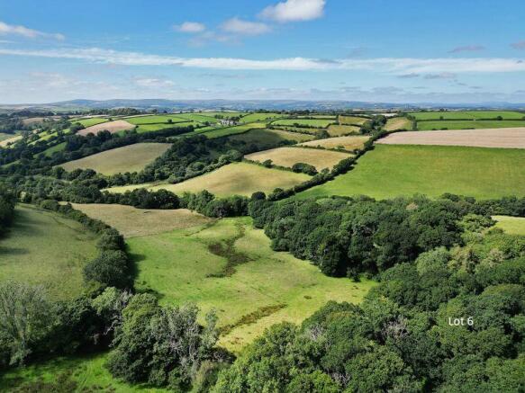
16.21 acres (6.56 hectares) situated in an idyllic secluded valley location offering privacy and with access from a council maintained public right of way. The land is comprised of 13.72 acres (5.55 hectares) of meadows and permanent grass and 2.49 acres (1.01 hectares) of natural regeneration broadleaf woodland to the east and north-west. The land is watered by streams that run through sections of the meadows.
Council Tax
Band D.
Services
House and Buildings: mains electric, mains water is running to an outside tap. The house is supplied by natural spring water and private drainage.
The Land: mains and natural water supply.
Energy Performance Certificate
Energy rating D.
Tenure
Freehold.
Local Authority
South Hams District Council, Follaton House, Plymouth Road, Totnes, Devon, TQ9 5NE.
Viewing Arrangements
Strictly by appointment with a member of the Rendells team.
Directions
From Totnes take the A381 towards Kingsbridge after about 3 miles you will enter the village of Harbertonford. Passing the Church on your right take the second right on to the Moreleigh Road. Continue for about 2 miles, passing a “T” junction called Spanish Lane end on your right. Then take the next right. At Farleigh Cross turn right, continue down the hill next left down the lane and the property can be found on your left.
Directions Continued
From the A38 Exit at the Marley Head Junction. Signed Paignton, South Brent, Avonwick. At the roundabout take the third exit on to Webland Lane bearing left up the hill and continue for 1.1 miles. At the Cross road continue straight over signed Diptford. At the next “T” junction turn right. Continue on this road for 4.2 miles turning right opposite a public foot path sign.
What3words: reworked.shredder.diplomas
Brochures
Property BrochureFull DetailsEnergy Performance Certificates
Energy Performance CertificateMoreleigh, Totnes
NEAREST STATIONS
Distances are straight line measurements from the centre of the postcode- Totnes Station5.7 miles
Notes
Disclaimer - Property reference 12480078. The information displayed about this property comprises a property advertisement. Rightmove.co.uk makes no warranty as to the accuracy or completeness of the advertisement or any linked or associated information, and Rightmove has no control over the content. This property advertisement does not constitute property particulars. The information is provided and maintained by Rendells, Totnes. Please contact the selling agent or developer directly to obtain any information which may be available under the terms of The Energy Performance of Buildings (Certificates and Inspections) (England and Wales) Regulations 2007 or the Home Report if in relation to a residential property in Scotland.
Map data ©OpenStreetMap contributors.


