
Church Road, Tasburgh, Norwich
- PROPERTY TYPE
Land
- SIZE
Ask agent
Key features
- PRIME RESIDENTIAL DEVELOPMENT SITE.
- JUST OVER 3 ACRES
- ROAD FRONTAGE OF APPROX 295' (89.92m)
- POPULAR VILLAGE LOCATION
- LOCAL AMENITIES NEARBY IN LONG STRATTON
- SUITABLE FOR 20 to 30 DWELLINGS
- SUITABLE FOR A MIX OF HOUSING TYPES
- TO INCLUDE A ONE THIRD AFFORDABLE HOUSING REQUIREMENT
- MAINS WATER, ELECTRICITY & DRAINAGE AVAILABLE
- FOR SALE FREEHOLD ON A CONDITIONAL CONTRACT SUBJECT TO PLANNING
Description
Tenure: Freehold
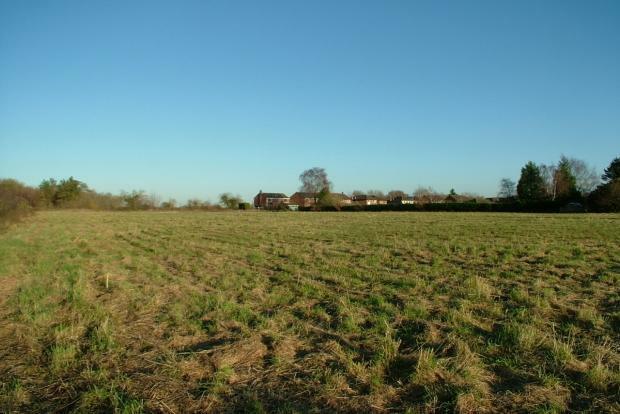
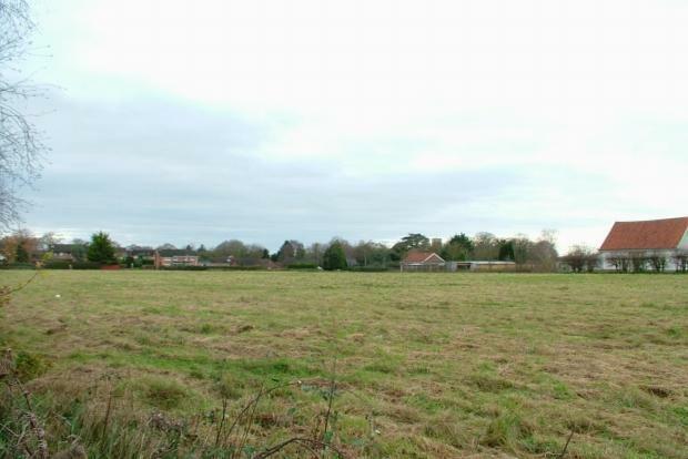
**RE-AVAILABLE** A prime level and rectangular greenfield site, of just over 3 acres, with an effective frontage of almost
300' to Church Road.
* Allocated for residential development in the adopted South Norfolk Local Plan.
* Located in this popular and sought after village just eight miles South of Norwich and two miles north
of the small town of Long Stratton, providing an extensive range of amenities.
* Suitable for development with twenty five to thirty dwellings and a mix of housing types, to include a one-
third affordable housing requirement.
* Mains water, electricity and drainage are available.
* For sale freehold, on a conditional contract subject to planning.
DESCRIPTION:
The land is former arable farmland which has not been under cultivation for a number of years, but has been recently rough grazed. It is reasonably level, falling only very slightly from the north to south, and backs onto paddocks and grassland. To the East are residential properties and the grounds of Preston CE VC Primary School, together with a turning head to Henry Preston Road, providing a potential second access point to the rear part of the land. To the West is an unmade access roadway which serves Old Hall Farmhouse, a converted barn and a bungalow, whilst on the opposite side of Church Road are substantial detached properties. The land has an effective frontage to Church Road of approximately 295' (89.92m), an actual frontage of approx 265' (80.77m), a width to the rear (North) of approx 215' (65.53m), a depth on the East side of approx 545' (166.12m) and a depth on the West side of approx 505' (153.92m). The area is approx 3.07 acres (1.24ha), subject to measured survey.
PLANNING:
The land is currently without planning permission, but has been allocated for residential development in the current Local Plan Site Specific and Policies Document, adopted by South Norfolk Council on 26th October 2015. It is the only land in Tasburgh allocated for development in the Local Plan. Policy TAS 1 in the document suggests the allocation could accommodate approximately 20 dwellings, but an Indicative Site Layout Plan has been prepared for a development of 32 mainly lower cost homes comprising a mix of detached, semi-detached and terraced houses served by a new access road from Church Road and by an extension to Henry Preston Road into the rear part of the site. This plan provides for 5 parking spaces to serve the adjoining Primary School. A copy of the plan forms part of these particulars, together with a copy of the Local Plan Map showing the location of the allocated land.
Policy TAS 1 in the Policies Document requires:
* Vehicular access to residential development on the site to be from a safe access onto Church Road;
* Pedestrian and cycle access to the School from the residential development on the site;
* Expansion or improvement to the School facilities as agreed with the Education Authority;
* Norfolk Minerals and Waste Core Strategy Policy CS16 applies, as the site is within a minerals and waste consultation area. Developers will need to consult Norfolk County Council (Minerals and Waste Policy) as part of any application on the site.
However, under the Village Clusters Housing Allocations Plan, for which a Public Consultation period has just concluded, Policy VC Tas 1 proposes an allocation of approximately 25 dwellongs (an increae4se of 5) for the land. The policy requires the developer to ensure:
- Access from Church Road, with a continuous vehicular and pedestrian link through to a second access from Henry Preston Road. Church Road to be widened to 5.5m in front of the site, with 2.0m footway connecting to existing provision;
- The layout and landscaping of the site respects and protects the setting of the nearby listed Old Hall Farmhouse;
- Early engagement with Anglian Water regarding the sewer crossing the site;
- The Historic Environment Record to be consulted to determine the need for any archaeological surveys prior to development;
- The existing woodland to the northern end of the site is protected and enhanced;
- Land is set aside for Use Class F1(a), for future expansion of Preston VC CE Primary School.
- There are no substantial trees on the land, which is not within a Conservation Area. The woodland referred to, at the northern end of the site, is mainly self-seeded coppice and scrub. The Local Education Authority (Norfolk County Council) have stated they have no plans to extend the School which would require the acquisition of additional land forming part of the site. Planning policy requires that one third of the dwellings are built as affordable homes.
SERVICES:
A foul sewer crosses the land and is understood to be available for connection, but intending purchasers should satisfy themselves by their own enquiries of Anglian Water. The position of the foul sewer is shown on the Indicative Site Layout Plan. Mains water and electricity are in close proximity to the land, but intending purchasers should make their own enquiries of the relevant authorities as to the availability of the services for connection and whether they are of sufficient capacity. There is no mains gas supply in Tasburgh. Intending purchasers should make their own enquiries of the Environment Agency as to requirements for the surface water drainage.
METHOD OF SALE:
The land is for sale freehold, by Private Treaty, with vacant possession on completion, on a contract conditional upon the purchasers obtaining planning consent, for their proposed development, within twelve months of exchange of conditional contracts. Offers are invited in the region of the Guide Price of £950,000.
DIRECTIONS:
From Long Stratton, proceed towards Norwich on the A140, continue over the new roundabout and, entering Tasburgh, turn left at the top of the hill into Church Road and the land is on the right hand side after about a third of a mile, with our "For Sale" board displayed. From Norwich, turn right, just past The Countryman PH, into Church Road.
Church Road, Tasburgh, Norwich

NEAREST STATIONS
Distances are straight line measurements from the centre of the postcode- Wymondham Station6.5 miles
About the agent
Aldridge Lansdell, Long Stratton
The Plain The Street, Long Stratton, NR15 2XG
CHARTERED SURVEYORS with over 100 years combined experience of the Property Market in Norwich & Norfolk serving individual and professional advisors in respect of residential and commercial properties.
- Committed to a quality service
- Chartered surveyors, estate agents, auctioneers & managers of residential & commercial property based in Norfolk.
- Chartered Surveyors able to provide a professional & comprehensive service in relation to property matters
Industry affiliations


Notes
Disclaimer - Property reference LOS-12M91F94. The information displayed about this property comprises a property advertisement. Rightmove.co.uk makes no warranty as to the accuracy or completeness of the advertisement or any linked or associated information, and Rightmove has no control over the content. This property advertisement does not constitute property particulars. The information is provided and maintained by Aldridge Lansdell, Long Stratton. Please contact the selling agent or developer directly to obtain any information which may be available under the terms of The Energy Performance of Buildings (Certificates and Inspections) (England and Wales) Regulations 2007 or the Home Report if in relation to a residential property in Scotland.
Map data ©OpenStreetMap contributors.