Afoneitha Road, Penycae, Wrexham
- PROPERTY TYPE
Land
- SIZE
Ask agent
Key features
- Extending to approximately 0.35 acres
- Outline planning permission
- Permission granted under code number Pen P/2019/0139
- Development is available showing layout for seven dwellings
- The site is level
- All services are available
Description
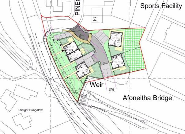
Extending to approximately 0.35 acres, this residential development site has achieved the grant of a reserved matters planning permission under Code Number Pen P/2022/0608 on 5th August 2022, which has recently been extended (under Code Number P/2024/1072, expiry August 2026. The scheme granted details a current layout of five dwellings comprising a pair of semi-detached houses and three detached houses. Previous schemes have been proposed upon the portion for a higher density development. The site is level and all services are available from nearby subject to statutory regulations.
Building land ready to go!
The Site
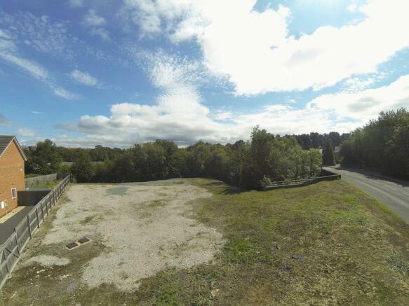
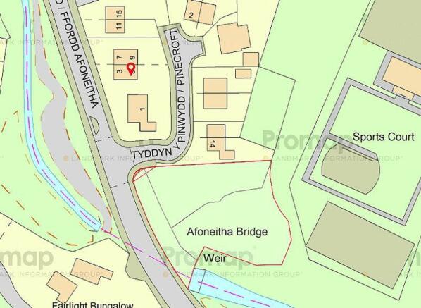
The site is situated on the very fringe of Penycae and comprises a level and cleared site topped with hardcore. An access road is constructed from the adjoining development 'Pine Croft'. The site measures approximately 0.35 acres. The depth of the site is approximately 42 meters with an average width of 32 meters.
Reporting and Supporting Documentation
Renewal of the Planning Permission for the residential development of the site was secured from Wrexham County Borough under Code Number Pen P/2022/0608 on 5/08/2022.
Additional documentation available include:
Planning Certificate.
106 Agreement.
Ecological Report.
Tree Report.
Topographical Survey.
Flooding Report and Flood Consequence Report.
These are available via email request from the Agents Wrexham Office. Enquiries to
Additional Information
The above reports are also available for download from Wrexham County Borough's Planning Portal at:
planning responses from the Statutory bodies is available from the Planning Portal regarding:
Highways.
Natural Resources Wales.
Coal Authority.
Welsh Water.
Services and Site Information
Running through the centre of the site there is a main foul drain. To the front portion of the site there is a mains water supply. Mains electricity and gas are available subject to statutory regulations. The position of each of these is marked upon the illustrative schematic layout attached.
The property has a boundary to the southern side onto a stream. There was a minor outbreak of Japanese Knotweed close to the site here, which has been treated with a guaranteed eradication contractor. A warranty is available in this regard.
Planning Permission
A reserved matters planning application for the site was successful on 5th August 2022 under Local Authority Code Number: Pen P/2022/0608.
Directions
Leave Wrexham on the A483 dual carriageway in the direction of Oswestry. Leave at the Llangollen junction and turn right under the flyover bridge following the Llangollen signs. At the roundabout continue ahead for Plas Madoc and after passing over the brow take the next right for Plas Bennion and Penycae. Pass through Plas Bennion and take the second right-hand turning. The property will be approached on the right.
Brochures
Property BrochureFull DetailsAfoneitha Road, Penycae, Wrexham
NEAREST STATIONS
Distances are straight line measurements from the centre of the postcode- Ruabon Station1.2 miles
- Wrexham Central Station4.2 miles
- Wrexham General Station4.4 miles
Notes
Disclaimer - Property reference 9794104. The information displayed about this property comprises a property advertisement. Rightmove.co.uk makes no warranty as to the accuracy or completeness of the advertisement or any linked or associated information, and Rightmove has no control over the content. This property advertisement does not constitute property particulars. The information is provided and maintained by Bowen, Wrexham. Please contact the selling agent or developer directly to obtain any information which may be available under the terms of The Energy Performance of Buildings (Certificates and Inspections) (England and Wales) Regulations 2007 or the Home Report if in relation to a residential property in Scotland.
Map data ©OpenStreetMap contributors.


