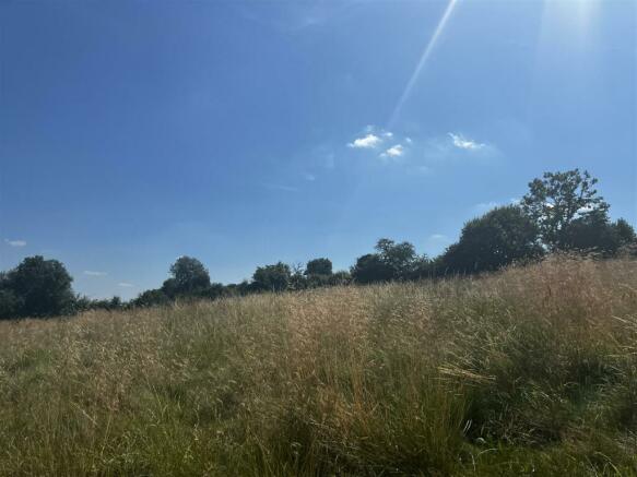
West Farndon, Daventry
- PROPERTY TYPE
Land
- SIZE
606,355 sq ft
56,332 sq m
Key features
- Pastureland extending to approximately 13.92 acres.
- Outskirt of village location
- Freehold with vacant possession upon completion
- Potential alternative use subject to obtaining the necessary planning permission.
Description
Pastureland extending to approximately 13.92 acres.
Location - The land is situated between the Northamptonshire villages of Byfield and West Farndon. Byfield is situated approximately 1.3 miles north, offering a wide variety of local amenities. The nearby market towns of Daventry and Banbury provide an extensive range of local amenities and services, together with vast education and employment opportunities. Banbury also provides access to mainline railway services providing access to London Marylebone and Birmingham New Street. The land benefits excellent road links with the A361, A45 and A5 providing access to the nearby motorway network of the M40 and M1.
The location is shown on the plan.
Description - The land is comprised of two enclosures of pastureland which extend to 13.92 acres (5.63 hectares) in total or thereabouts, with well-defined mature hedgerow and tree boundaries throughout. Field 1 has previously been used for grazing, with Field 2 having previously been used as a mountain bike and BMX track, with evidence of a physical track still in place.
Access to the land is via a single track off Church Street, with the land benefitting from a right of way, 6m wide, along the track shaded blue on the plan for all purposes.
According to Natural England, the land is classified as Grade 3 on the Agricultural Land Classification Maps, being freely draining slightly acid but base-rich soil, with high fertility. The land would be suited to equestrian or alternative use subject to obtaining the necessary planning consents.
The property is available as a whole.
Tenure & Possession - The property is offered for sale freehold with vacant possession upon completion.
Title - The land is currently registered under title numbers NN298414, N315986 and NN360928.
Services - The vendor believes that land is connected to mains water, with the land benefitting from a supply through the adjoining landowner’s property subject to the purchaser paying for the cost of water used on the property together with all easements, rights and privileges over the adjoining and neighbouring land necessary and property for inspecting, cleaning, repairing, maintaining, renewing and re-instating the same.
Purchasers should note that it is their specific responsibility to make their own enquiries to the appropriate authorities as to the location, adequacy and availability of mains water, electricity, gas and drainage services. The cost of providing such services to the site will be at the purchaser’s own expense.
Overage Clause - The property will be sold subject to a development uplift clause which will reserve 30% of any increase in value on each and every non-agricultural or non-equestrian development that takes place within a period of 30 years from the date of sale.
Method Of Sale - The property will be offered for sale by private treaty as a whole and interested parties should submit their offers to the Towcester Office.
Rights Of Way Etc. - Access to the property can be gained via a track situated off Church Street, which is owned by a third party, as shown hatched blue on the location plan.
The property is sold subject to and with the benefit of all rights of way, easements and wayleaves that may exist over the same whether disclosed or not.
Plan, Area & Description - The plan, area and description are believed to be correct in every way, but no claim will be entertained by the vendor or the agents in respect of any error, omissions or misdescriptions. The plan is for identification purposes only.
Fixtures & Fittings - Only those items in the nature of fixtures and fittings mentioned in these particulars are included in the sale. Other items are specifically excluded.
There are a number of items located on the property associated with the vendor’s use as a BMX facility, which may be available by separate negotiation.
What3words - ///reporters.chilled.versions
Viewing - Strictly by prior appointment via the selling agent
Howkins and Harrison
Brochures
Land to the west of crosstree farm TC V2.pdfBrochureWest Farndon, Daventry
NEAREST STATIONS
Distances are straight line measurements from the centre of the postcode- Banbury Station8.3 miles
At Howkins & Harrison, we are an independent firm of Chartered Surveyors, Auctioneers, Estate Agents, Valuers and Chartered Planners, with a reputation for providing a professional service.
We have been supporting homeowners, landowners and landlords since 1888 and we have 7 regional, high street offices and over 80 employees. We also have the benefit of an office on St James's Place in London, to promote our portfolio to commuters.
Covering a wide area of the Midlands, working across Warwickshire, Northamptonshire and Leicestershire, We offer total land, property & estate services for residential, commercial and agricultural clients.
If you're looking to buy, sell, let, rent, auction, extend, finance or develop, our experienced team are here to help.
Our Towcester office is located on Watling Street within the main town centre. There is free parking just outside the office. If you are able to pop in, we'd be delighted to see you.
Notes
Disclaimer - Property reference 33378910. The information displayed about this property comprises a property advertisement. Rightmove.co.uk makes no warranty as to the accuracy or completeness of the advertisement or any linked or associated information, and Rightmove has no control over the content. This property advertisement does not constitute property particulars. The information is provided and maintained by Howkins & Harrison LLP, Towcester. Please contact the selling agent or developer directly to obtain any information which may be available under the terms of The Energy Performance of Buildings (Certificates and Inspections) (England and Wales) Regulations 2007 or the Home Report if in relation to a residential property in Scotland.
Map data ©OpenStreetMap contributors.


