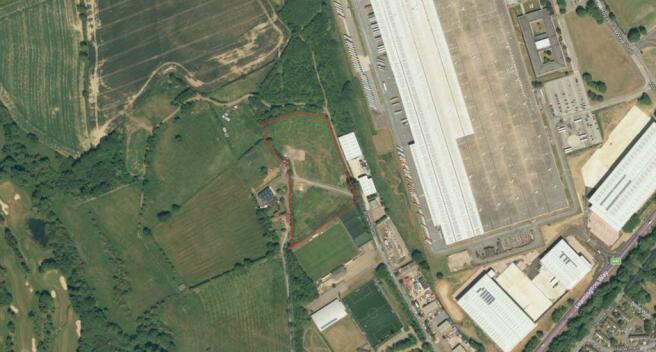
Land At Browns Road, Daventry, Northamptonshire, NN11
- SIZE AVAILABLE
158,558 sq ft
14,731 sq m
- SECTOR
Land to lease
Lease details
- Lease available date:
- Ask agent
- Lease type:
- Long term
Description
There is a planning application running for high-quality open-storage accommodation and parking, with 88 HGV spaces and 44 car spaces.
The site currently is comprised of some hardstanding with the majority being grassed land. The perimeter fencing is agricultural. Our client would consider investing in upgrading the site or offering a rent holiday if the Tenant were to invest - dependent upon circumstances.
The site is located off Browns Road which is within close proximity to the established employment areas of Drayton Fields Industrial Estate, Royal Oak Industrial Estate and High March Industrial Estate and is 1.5 miles from the town centre.
Daventry is located approximately 12 miles west of Northampton and 10 miles south of Rugby, being centrally located with excellent access to the motorway network via the A45, A5 and A361. Junction 16 of the M1 motorway is approximately 7 miles distant, the M45 is approximately 7 miles distant, Junction 18 of the M1 motorway is approximately 8 miles, Junction 1 of the M6 15 miles and Junction 11 of the M40 is approximately17 miles.
Daventry benefits from the new A45 M1 link road, which has helped significantly reduce travel times.
Luton, Birmingham and East Midlands International Airports are all within a 1 hour drive.
85% of the UK population lives within a 4.5 hour drive
DIRFT rail/road intermodal fright terminal is located within 9 miles to the north and directly along the A5
The UK's second busiest cargo airport (East Midlands Airport) is within 45 miles and Birmingham Airport is within 30 miles
Brochures
Land At Browns Road, Daventry, Northamptonshire, NN11
NEAREST STATIONS
Distances are straight line measurements from the centre of the postcode- Long Buckby Station5.1 miles
Notes
Disclaimer - Property reference 4969LH. The information displayed about this property comprises a property advertisement. Rightmove.co.uk makes no warranty as to the accuracy or completeness of the advertisement or any linked or associated information, and Rightmove has no control over the content. This property advertisement does not constitute property particulars. The information is provided and maintained by MATHER JAMIE LIMITED, Loughborough. Please contact the selling agent or developer directly to obtain any information which may be available under the terms of The Energy Performance of Buildings (Certificates and Inspections) (England and Wales) Regulations 2007 or the Home Report if in relation to a residential property in Scotland.
Map data ©OpenStreetMap contributors.


