
Grazing Land off Harrots Lane, Hartington, Nr. Buxton

Letting details
- Let available date:
- Ask agent
- PROPERTY TYPE
Land
- SIZE
Ask agent
Key features
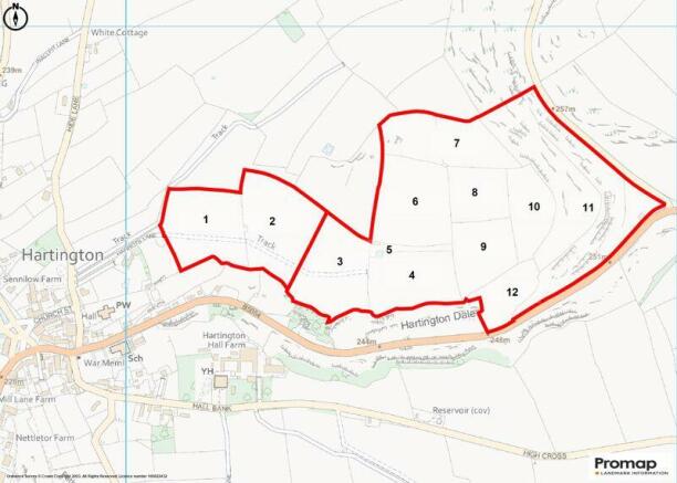
- Block of Sound Grassland extending to 51.94 Acres
- Available from 1st April to 31st December 2023
- Well suited to the grazing of cattle and the majority mowable
- Offers to be recieved by 15th March 2023 by 12 noon
Description
To Let By Informal Tender – Closing Date 15th March 2023
Location
The land is situated to the east of the village of Hartington and accessed off an unadopted stone track known as Harrots Lane (off Hide Lane) on the western boundary and also off the B5054 road on the south eastern boundary that links to the A515 (Buxton to Ashbourne Road).
The Ordnance Survey Reference Number is: SK130606
What3Words:///found.gentlemen.boarding
Viewing
The land may be viewed during daylight hours whilst in possession of a copy of these particulars and which will constitute authority to view. Please ensure that all gates are left as found and latched or tied correctly. Anyone inspecting the land does so entirely at their own risk and neither the agents nor the landowners accept any responsibility or liability for any injuries or consequential loss howsoever caused.
Description
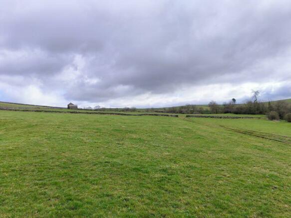
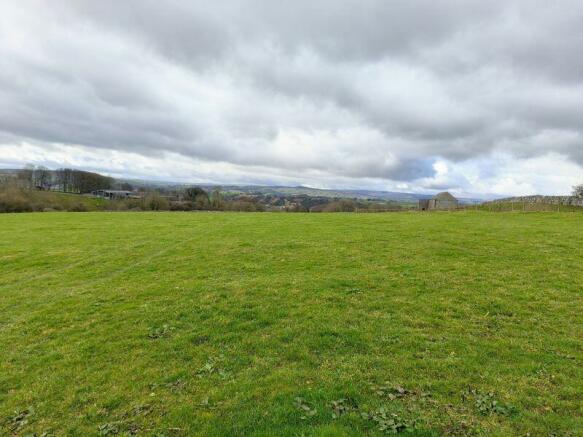
The land is shown on the attached plan edged red and is considered to be in good heart and suitable for the grazing of cattle and the majority is mowable. Parcels 1,2,3,4,6,8 and 9 are considered to be mowing fields being generally level. Parcels 5, 7, 10, 11 and 12 are more undulating and sloping in parts and are more suited to grazing. A stone track runs through parcels 1,2 & 3. There are sound internal stone walls and interconnecting gateways between parcels to assist with grazing management.
Services
No mains services are connected to the land. There are two ponds situated on the land, with one adjacent to the larger of the two stone barns within parcel 5 and a second on the roadside boundary of parcel 11 and these provide natural water, however interested parties should make their own inspection with regards to these sources and their suitability and reliability.
Terms
The land is available from 1st April 2023 until 31st December 2023, upon which all livestock must be removed. Following the expiry of the initial term a longer term agreement may be considered by the Landowners for subsequent years.
The Grazier will be required to sign a grazing and mowing agreement and pay the rent in full for the term prior to occupation being granted.
The Basic Payment Scheme is not claimed on by the Landowner and no entitlements are included with the letting of the land.
The Grazier will be responsible for ensuring that the boundary fences and walls are stockproof and make good or erect temporary fencing as appropriate. Interested parties should satisfy themselves as to the condition of fences prior to offering for the land.
There are two barns of stone construction situated on the land and these will be specifically excluded from the agreement.
All offers must be made in writing on the attached Tender Form and received at our Leek Office by 12 noon on...
Brochures
Property BrochureFull DetailsGrazing Land off Harrots Lane, Hartington, Nr. Buxton

NEAREST STATIONS
Distances are straight line measurements from the centre of the postcode- Buxton Station9.3 miles


Notes
Disclaimer - Property reference 11891023. The information displayed about this property comprises a property advertisement. Rightmove.co.uk makes no warranty as to the accuracy or completeness of the advertisement or any linked or associated information, and Rightmove has no control over the content. This property advertisement does not constitute property particulars. The information is provided and maintained by Whittaker & Biggs, Leek. Please contact the selling agent or developer directly to obtain any information which may be available under the terms of The Energy Performance of Buildings (Certificates and Inspections) (England and Wales) Regulations 2007 or the Home Report if in relation to a residential property in Scotland.
Map data ©OpenStreetMap contributors.