Upper Anstey Lane, Parish of Shalden, GU34
- PROPERTY TYPE
Detached Bungalow
- BEDROOMS
4
- BATHROOMS
2
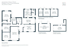
- SIZE
1,972 sq ft
183 sq m
- TENUREDescribes how you own a property. There are different types of tenure - freehold, leasehold, and commonhold.Read more about tenure in our glossary page.
Freehold
Key features
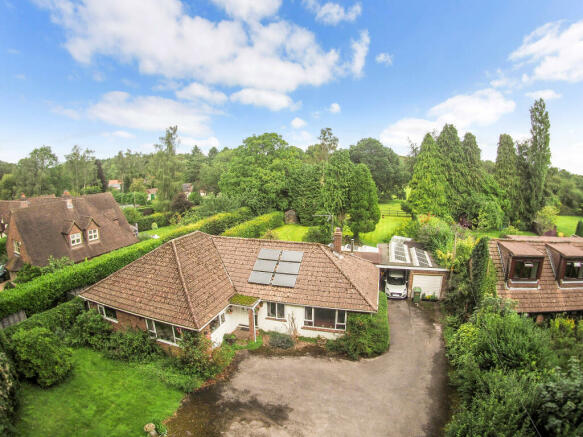
- In all Gardens and Grounds of about 2.93 acres (1.186 hectares)
- Reception Hall
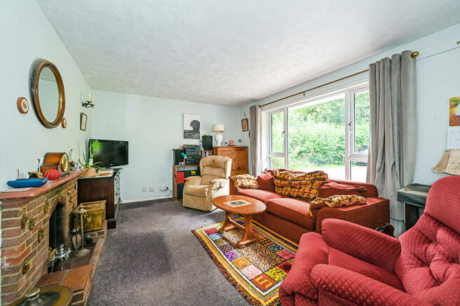
- Sitting Room
- Dining Room
- Family Room
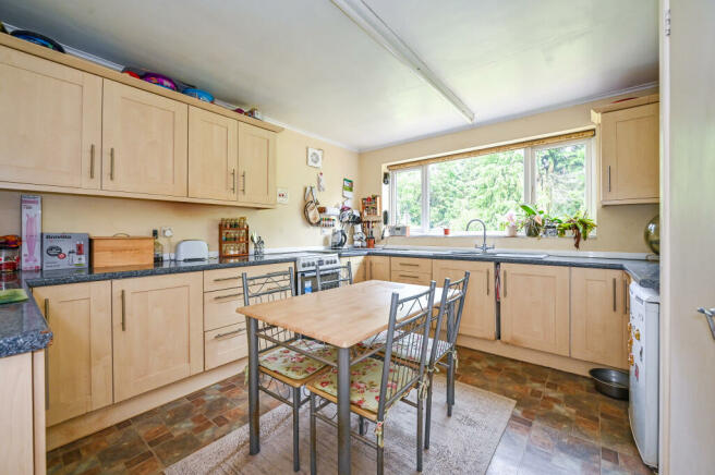
- Kitchen/Dining Room
- Utility Room
- Cloakroom
- 4 Bedrooms
- En Suite Bathroom
Description
Outside
The grounds and paddocks are of particular note, extending in all to about 3 acres. A tarmac driveway from the lane provides ample parking and access to the garage and adjoining car port. An access way to one side provides a route to the paddocks. The gardens and grounds take full advantage of the mature setting with a variety of areas of interest together with a paved terrace set off the rear of the property. The garden is mainly laid to lawn with fine views over the paddocks towards the woodland beyond. To the rear of the garden, there is a stable block (with power) with two loose boxes and a tack room together with a separate stable outbuilding (with power and adjoining the vegetable garden). There are two paddocks (the first of about 1.5 acres and 2nd of about an acre) with inter connecting gates and post and rail fencing. A public footpath extends across the rear of the paddocks. A fence has been erected ahead of the footpath to ensure separation between the paddocks and the footpath.
Situation
The property occupies a very mature and secluded location. Upper Anstey Lane is a small no-through lane in-between the villages of Froyle and Shalden. It forms part of Shalden Parish and is about 1½ miles to the north of the historic market town of Alton. The surrounding countryside provides opportunity for many country pursuits. The historic market town of Alton has a good range of high street shops, Waitrose, Sainsbury’s, M&S Simply Food, weekly and specialist markets, schooling for all age groups including Alton School, Eggar’s, Amery Hill and Alton College as well as a sports centre, two outlying golf courses and a mainline station to London Waterloo.
Brochures
Brochure- COUNCIL TAXA payment made to your local authority in order to pay for local services like schools, libraries, and refuse collection. The amount you pay depends on the value of the property.Read more about council Tax in our glossary page.
- Band: F
- PARKINGDetails of how and where vehicles can be parked, and any associated costs.Read more about parking in our glossary page.
- On street,Garage
- GARDENA property has access to an outdoor space, which could be private or shared.
- Private garden
- ACCESSIBILITYHow a property has been adapted to meet the needs of vulnerable or disabled individuals.Read more about accessibility in our glossary page.
- Ask agent
Upper Anstey Lane, Parish of Shalden, GU34

Add your favourite places to see how long it takes you to get there.
__mins driving to your place


Your mortgage
Notes
Staying secure when looking for property
Ensure you're up to date with our latest advice on how to avoid fraud or scams when looking for property online.
Visit our security centre to find out moreDisclaimer - Property reference a1nQ5000003Ul32IAC. The information displayed about this property comprises a property advertisement. Rightmove.co.uk makes no warranty as to the accuracy or completeness of the advertisement or any linked or associated information, and Rightmove has no control over the content. This property advertisement does not constitute property particulars. The information is provided and maintained by Hamptons, Alton. Please contact the selling agent or developer directly to obtain any information which may be available under the terms of The Energy Performance of Buildings (Certificates and Inspections) (England and Wales) Regulations 2007 or the Home Report if in relation to a residential property in Scotland.
*This is the average speed from the provider with the fastest broadband package available at this postcode. The average speed displayed is based on the download speeds of at least 50% of customers at peak time (8pm to 10pm). Fibre/cable services at the postcode are subject to availability and may differ between properties within a postcode. Speeds can be affected by a range of technical and environmental factors. The speed at the property may be lower than that listed above. You can check the estimated speed and confirm availability to a property prior to purchasing on the broadband provider's website. Providers may increase charges. The information is provided and maintained by Decision Technologies Limited. **This is indicative only and based on a 2-person household with multiple devices and simultaneous usage. Broadband performance is affected by multiple factors including number of occupants and devices, simultaneous usage, router range etc. For more information speak to your broadband provider.
Map data ©OpenStreetMap contributors.