Armadale Residential Dev Site, Abbey Road, Barrow-In-Furness, Cumbria

- SIZE
Ask agent
- TENUREDescribes how you own a property. There are different types of tenure - freehold, leasehold, and commonhold.Read more about tenure in our glossary page.
Freehold
Key features
- Planning approval for three residential dwellings under references B13/2020/0107 and B13/2023/0493
- Convenient location just 2 miles from Barrow-in-Furness Town Centre.
- Level site in a thriving residential area.
- Frontage to Abbey Road.
Description
escription
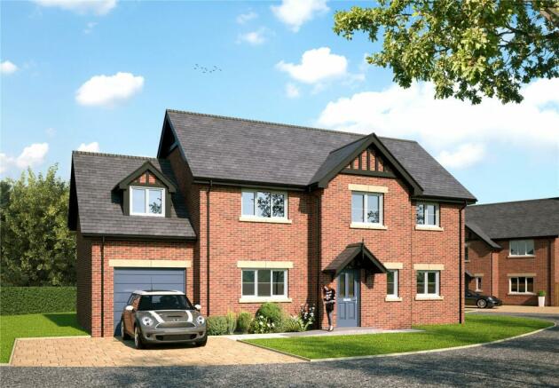
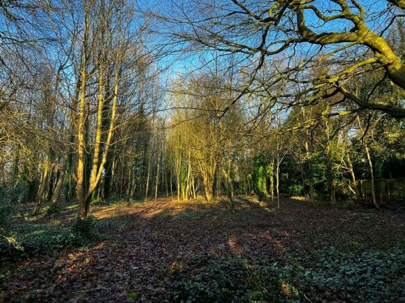
The site extends to approximately 0.97 acres (0.39 ha) of development land, with planning permission approved to build three residential dwellings. The site is level and comprises of a mixture of deciduous trees. The site is easily accessible from Abbey Road, with a gateway in the parking area just off the road leading to the church.
Planning
The site has planning permission for three residential dwellings. Outline Planning Permission and Reserved Matters have been approved. The planning applications may be viewed via The Borough of Barrow-in-Furness Planning Hub website, link below:
2:
Outline Planning Permission (reference B13/2020/0107) was granted by Barrow-in-Furness Council 8th September 2020.
As per the decision notice attached to these particulars, approval of Reserved Matters (reference B13/2023/0493 was granted by Barrow-in-Furness Council on 29th September 2023 for carrying out the development in accordance with the application and plans submitted and subject to the following conditions:
Compliance with Approved Plans
1. The development shall be carried out and completed in all respects in accordance with the application dated 24/07/23 and the hereby approved documented defined by this permission, as detailed in decision notice 230493; except where varied by conditions attached to this consent.
During Building Works
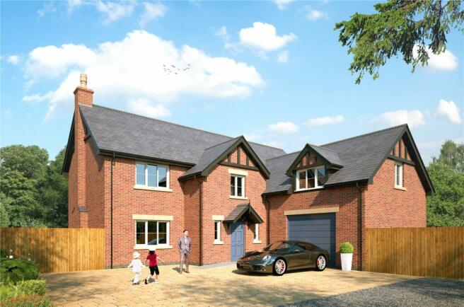
2. The development shall be carried out in accordance with the materials hereby approved (natural slate roofs and ‘Furness Brick Old Terracotta’ facing brick as specified in email from the agent received 27/09/23) and thereafter retained unless the Planning Authority gives prior written consent to any variation.
Before Occupation
3. All planting, seeding or turfing comprised in the approved details of landscaping shall be carried out in the first planting and seeding seasons following beneficial occupation of any part of the development, or in accordance with the phasing of the scheme as agreed in the completion of the development die, are removed, or become seriously damaged or diseased, shall be replaced by the landowner in the next planting season with others of a similar size and species, unless the Planning Authority gives prior written consent to any variation.
Directions
Heading North East out of Barrow-in-Furness, take a right turn at the mini roundabout onto Abbey Road. Continue along Abbey Road for approximately 1.8 miles. Turn left at the road to the Church entrance and the site is located on your right, just before the church entrance.
From Ulverston, take the A590 towards Barrow-in-Furness for approximately 8 miles, before taking a left at Park Road Roundabout onto Park Road. Continue along Park Road for approximately 7 miles before taking the second exit at the roundabout onto Abbey Road. Continue on Abbey Road for approximately 8 miles, turn right at road leading to the church and the site is located on the immediate right, just before the main church entrance.
Location
The site is located on the outskirts of the popular town of Barrow-in-Furness on Abbey Road, approximately 2 miles out of Barrow-in-Furness Town Centre.
What3Words: stale.shovels.formed
Grid reference: SD
Services
Overage
The site will be sold subject to a 20 year overage whereby the vendor shall be due 50% of the uplift in value of the site should planning permission be granted for an additional (fourth) dwelling.
Tenure
Freehold.
Vacant possession upon completion.
Services
It is understood that services, electricity, water and drainage are available in close proximity to the site.
Potential buyers must make their own enquiries with the service providers.
Local Authority
Westmorland and Furness Council. Tel No: .
Sale Plan
The sale plan has been prepared by the selling agent for the convenience of the prospective purchasers. It is deemed to be correct, but any error, omission or mis-statement shall not affect the sale. Purchasers must satisfy themselves as to accuracy.
Wayleaves and Easements
The property is sold subject to and with the benefit of any existing easements, wayleaves and rights of way. The sale is subject to all the existing rights of way, drainage, light, air support and other easements and quasi-easements and outgoings whether mentioned in these particulars or not.
Viewing
The land may be viewed at any reasonable time, provided a copy of these particulars are in possession. Tel No; , Option 3.
Brochures
Particulars- COUNCIL TAXA payment made to your local authority in order to pay for local services like schools, libraries, and refuse collection. The amount you pay depends on the value of the property.Read more about council Tax in our glossary page.
- Band: TBC
- PARKINGDetails of how and where vehicles can be parked, and any associated costs.Read more about parking in our glossary page.
- Yes
- GARDENA property has access to an outdoor space, which could be private or shared.
- Ask agent
- ACCESSIBILITYHow a property has been adapted to meet the needs of vulnerable or disabled individuals.Read more about accessibility in our glossary page.
- Ask agent
Energy performance certificate - ask agent
Armadale Residential Dev Site, Abbey Road, Barrow-In-Furness, Cumbria
Add an important place to see how long it'd take to get there from our property listings.
__mins driving to your place
Get an instant, personalised result:
- Show sellers you’re serious
- Secure viewings faster with agents
- No impact on your credit score
Your mortgage
Notes
Staying secure when looking for property
Ensure you're up to date with our latest advice on how to avoid fraud or scams when looking for property online.
Visit our security centre to find out moreDisclaimer - Property reference KEN230232. The information displayed about this property comprises a property advertisement. Rightmove.co.uk makes no warranty as to the accuracy or completeness of the advertisement or any linked or associated information, and Rightmove has no control over the content. This property advertisement does not constitute property particulars. The information is provided and maintained by H&H Land & Estates, Penrith. Please contact the selling agent or developer directly to obtain any information which may be available under the terms of The Energy Performance of Buildings (Certificates and Inspections) (England and Wales) Regulations 2007 or the Home Report if in relation to a residential property in Scotland.
*This is the average speed from the provider with the fastest broadband package available at this postcode. The average speed displayed is based on the download speeds of at least 50% of customers at peak time (8pm to 10pm). Fibre/cable services at the postcode are subject to availability and may differ between properties within a postcode. Speeds can be affected by a range of technical and environmental factors. The speed at the property may be lower than that listed above. You can check the estimated speed and confirm availability to a property prior to purchasing on the broadband provider's website. Providers may increase charges. The information is provided and maintained by Decision Technologies Limited. **This is indicative only and based on a 2-person household with multiple devices and simultaneous usage. Broadband performance is affected by multiple factors including number of occupants and devices, simultaneous usage, router range etc. For more information speak to your broadband provider.
Map data ©OpenStreetMap contributors.


