Gardener's Hall & Grove Mount, Blackburn, Bathgate, West Lothian, EH47
- PROPERTY TYPE
Land
- SIZE
3,281,810 sq ft
304,890 sq m
Key features
- Traditional farmhouse (in need of modernisation)
- Ruin cottage and traditional farm buildings with development potential (subject to the necessary consents)
- Useful modern cattle shed and a number of timber store sheds
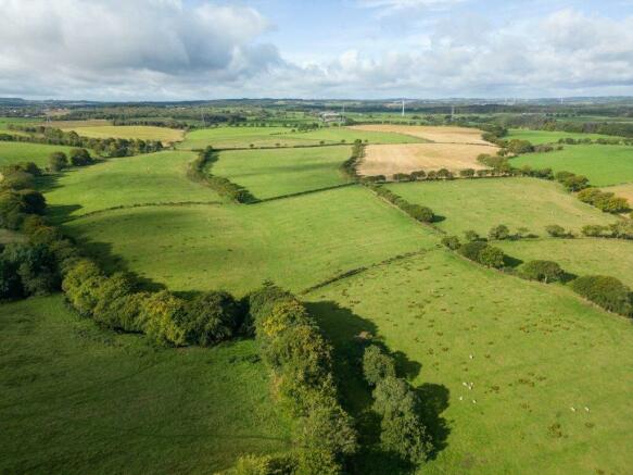
- Productive block of farmland used for grazing and fodder production
- Land situated in a contiguous block benefitting from good public road access
- Situated in a rural position with views over the surrounding countryside
- Potential to expand environmental and forestry interests through natural capital and afforestation schemes
- About 30.49 Ha (75.34 Acres) in total
- For sale as a whole or in 2 lots
Description
Closing Date Set for 12.00 noon on Thursday 2 May 2024.
SITUATION
Gardener's Hall and Grove Mount are located approximately 1 mile to the south of the settlement of Blackburn within rural West Lothian, about 4 miles west of Livingston and 2.5 miles from junction 4 of the M8 providing swift access links Edinburgh and Glasgow.
There is a good range of local shops and a primary school in nearby Blackburn with a wider range of shopping and commercial facilities in nearby Bathgate, West Calder, and Livingston. Livingston which is West Lothian's largest town is situated a short drive to the east and has an excellent range of shopping and recreational facilities including multi-screen cinema, two large shopping centres and a swimming pool. Scotland's capital city of Edinburgh is only 24 miles to the east and is home to renowned hotels and restaurants alongside large entertainment venues and events.
Gardener's Hall and Grove Mount are conveniently located for the commuter being only a short distance from all main arterial routes including the M8 and M9 motorways. Rail links are available from nearby West Calder and Bathgate with services to Edinburgh and Glasgow. Edinburgh and Glasgow Airports are 16.5 and 36.5 miles respectively offering a wide range of domestic and international flights.
The area is well provided for by a number of agricultural merchants, suppliers and machinery dealers, along with several locally based equestrian suppliers. Nearby Lanark Market (20 miles) and Stirling Markets (29 miles) provide excellent outlets for high quality livestock which the surrounding area is renowned for producing.
DESCRIPTION
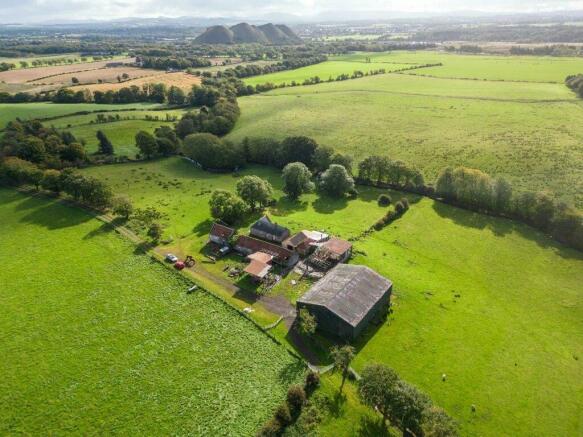
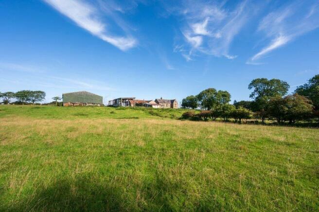
Gardener's Hall and Grove Mount provide a compact farming unit equipped with a traditional farmhouse, ruin cottage, and one useful and adaptable modern shed, along with a range of traditional outbuildings which may present longer term development potential subject to obtaining necessary consents. The property is equipped with an area of farmland which extends to approximately 30.49 Ha (75.34 Acres) in total and surrounds the farmhouse, cottage and buildings.
METHOD OF SALE
Gardener's Hall and Grove Mount are offered for sale either as a whole or in 2 lots.
Lot 1: Gardener's Hall Farmhouse, Buildings and land extending to about 28.16 Ha (69.58 Acres) in total
Lot 2: Grove Mount Cottage and outbuildings and land extending to approximately 2.33 Ha (5.76 Acres) in total
LOT 1: LAND AND BUILDINGS AT GARDENER'S HALL EXTENDING TO 28.16 Ha (69.58 Acres)
The subjects at Gardener's Hall, comprise a compact farming unit and are accessed either via a private road which is shared with Grove Mount, and leads off the minor public road which links Blackburn to the B7015/Westwood, or via field gates which lead directly onto B792 which bounds the subjects to the west.
Gardener's Hall Farmhouse (13.7m x 4.89m NIA)
Located to the east of the holding and accessed via the internal farm road there is a former farmhouse of traditional stone construction under a slate roof. The property provides accommodation over one level, and is currently uninhabitable requiring modernisation throughout and presents a unique opportunity to develop into a substantial family home in a secluded position within the farm.
Outbuildings
Located adjacent to the farmhouse, there is also a range of adjacent traditional outbuildings of stone construction under pantile and corrugated roofs which are also in a dilapidated state. There are several timber stores situated adjacent to the outbuildings used for ancillary storage.
Hay Shed (23.3m x 17.0m)
Located to the west of the farmhouse there is a modern hay shed which is of timber frame construction under a box profile roof with an earth floor.
Farmland
The Land in Lot 1 extends to approximately 28.16 Ha (69.58 Acres) in total including roads, yards and buildings and surrounds the farmhouse and buildings and extends to the B792 public road which bounds the subjects to the west. The majority of the farmland is currently down to pasture and has been classified by the James Hutton Institute as Grade 3.2 and Grade 4.2. The land is gently undulating but rises overall from 150m above sea level at its lowest point to the south east of the steading to 166m at its highest point to the west of the of the holding. The land has predominantly been used for grazing and fodder production and is bound to the south by the Foulshiels Burn and the Bickerton Burn also bounds part of the subjects to the north east of the holding.
LOT 2: LAND AND BUILDINGS AT GROVE MOUNT EXTENDING TO APPROXIMATELY 2.33 HA (5.76 ACRES)
The subjects at Grove Mount are situated to the east of Gardener's Hall and are accessed via a private road which is shared with Gardener's Hall and leads off the minor public road which links Blackburn to the B7015/Westwood Road.
Ruin Cottage & Outbuildings
Grove Mount comprises part of the original stone cottage which is now in ruinous state and one stand-alone brick building under a corrugated roof. There are also the remains of a Walled Garden to the east of the cottage ruins.
Farmland
The Land in Lot 2 extends to approximately 2.33 Ha (5.76 Acres) in total and has been classified by the James Hutton Institute as primarily Grade 4.2 and is currently down to grass. The land rises overall from 149m above sea level at its lowest point to south of the holding adjacent to the Foulshiels Burn to 152m at its highest point to the north east of the buildings. The land sits in a contiguous block and would be well suited to amenity and equestrian use.
Brochures
ParticularsGardener's Hall & Grove Mount, Blackburn, Bathgate, West Lothian, EH47

NEAREST STATIONS
Distances are straight line measurements from the centre of the postcode- Addiewell Station1.4 miles
- West Calder Station1.7 miles
- Bathgate Station2.8 miles
About Galbraith, Stirling
Suite C1, Stirling Agricultural Centre, Stirling, FK9 4RN


Notes
Disclaimer - Property reference STR230061. The information displayed about this property comprises a property advertisement. Rightmove.co.uk makes no warranty as to the accuracy or completeness of the advertisement or any linked or associated information, and Rightmove has no control over the content. This property advertisement does not constitute property particulars. The information is provided and maintained by Galbraith, Stirling. Please contact the selling agent or developer directly to obtain any information which may be available under the terms of The Energy Performance of Buildings (Certificates and Inspections) (England and Wales) Regulations 2007 or the Home Report if in relation to a residential property in Scotland.
Map data ©OpenStreetMap contributors.