Land at Valleyfield, Penicuik

- SIZE AVAILABLE
29,621-445,183 sq ft
2,752-41,359 sq m
- SECTOR
Land for sale
Key features
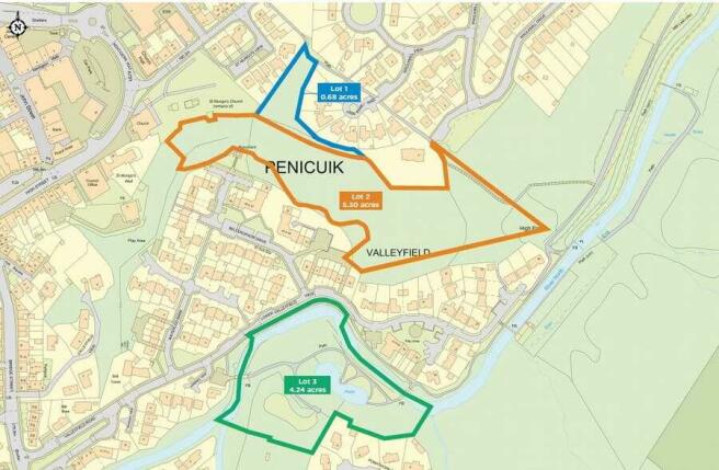
- Woodland/amenity ground available in 3 lots
- Total of around 10.22 acres/4.14 hectares
- Offers invited for individual lots or as a whole
Description
Approx 0.68 acres/0.27 ha site comprising open ground with some vegetation, positioned between residential properties at St Mungo’s View to the west and High Park Rise to the east. The north of the site includes a public footpath between Kirkhill Road and Waulkmill View. The land has potential for amenity/garden use, subject to necessary consents.
Planning position – The land is designated under policy DEV8 – Open Spaces (Within Settlement Area) within the Midlothian Development Plan.
Lot 2 (Orange)
Approx. 5.30 acres/2.15 ha site comprising woodland positioned between residential properties (north/south), Penicuik Trinity Community Church (west) and further woodland (east). The east of the site includes a public footpath between Waulkmill View and the Penicuik to Dalkeith Walkway.
Planning position – The land is designated under policies DEV8 Open Spaces (Within Settlement Area) and ENV8 Protection of River Valleys within the Midlothian Development Plan. The land is within Penicuik Conservation Area, whose Appraisal document notes the land as an “important and extensive band of mixed woodland”
Lot 3 (Green)
Approx. 4.24 acres/1.72 ha site comprising woodland positioned between residential properties (north, south, west) and further woodland (east). The site includes Valleyfield Pond and part of the River North Esk, which runs along the northern boundary, with its tributary the Black Burn joining within the site to the south-west. A number of footpaths are also located within the site including the Penicuik to Dalkeith Walkway which starts at the bridge over the River North Esk to the west.
Planning position – The land is designated under policies DEV8 Open Spaces (Within Settlement Area) (east part of site); ENV8 Protection of River Valleys; and ENV14 Regionally and Locally Important Nature Conservation Sites within the Midlothian Development Plan. The land is within Penicuik Conservation Area, whose Appraisal document notes the
land as a “mature semi-natural woodland” with “an attractive small park and pond.”
The land is located to the south-east of Penicuik, Midlothian, a town located around 14 km/9 miles south of Edinburgh city centre.
A popular commuter settlement, Penicuik hosts a range of educational, retail, leisure and community amenities.
The Pentland Hills, Penicuik Estate and Glencourse Golf Club offer easily accessible outdoor activities.
Straiton Retail Park, The City of Edinburgh Bypass, Easter Bush Campus and Roslin Glen Country Park are all within 10 km/6 miles of the land for sale.
Brochures
Land at Valleyfield, Penicuik

NEAREST STATIONS
Distances are straight line measurements from the centre of the postcode- Curriehill Station6.5 miles
About Savills, Glasgow - Development
163 West George Street, Glasgow, G2 2JJ
Notes
Disclaimer - Property reference E7C83634-DB90-4BE9-B024-29D71ED35B3F. The information displayed about this property comprises a property advertisement. Rightmove.co.uk makes no warranty as to the accuracy or completeness of the advertisement or any linked or associated information, and Rightmove has no control over the content. This property advertisement does not constitute property particulars. The information is provided and maintained by Savills, Glasgow - Development. Please contact the selling agent or developer directly to obtain any information which may be available under the terms of The Energy Performance of Buildings (Certificates and Inspections) (England and Wales) Regulations 2007 or the Home Report if in relation to a residential property in Scotland.
Map data ©OpenStreetMap contributors.