Sutton Road, WS9
- PROPERTY TYPE
Farm
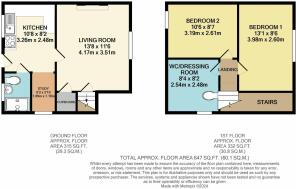
- BEDROOMS
4
- BATHROOMS
2
- SIZE
Ask agent

Key features
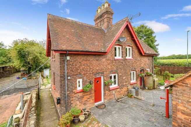
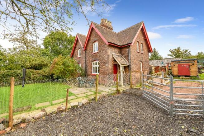
- A pair of Victorian semi-detached cottages
- 14.66 acres of land in total
- Traditional buildings with potential, subject to planning
- Stabling for six ponies
- Diversified income potential
- For sale as a whole - additional lots are available
- For sale by Private Treaty
Description
Moat Farm provides an excellent opportunity to acquire a 14.66 acre farm in the green oasis between Walsall, Aldridge and Streetly. One of the last farms in the Walsall area, the farm lies close to Barr Beacon and is a short distance from the Sutton Park National Nature Reserve.
HISTORICAL NOTE
The historic moated site lying adjacent to the farmstead is a scheduled Monument with List Entry number 1008547 recorded in the Historic England website. The moat interior is accessed over a small brick bridge on the eastern area of the moat and this area has been used for vehicle and caravan storage since World War II. The former house within the moat was demolished in the 1870's.
The list entry states: 'The site has survived unencumbered by modern development and may retain archaeological deposits associated with the site and its inhabitants. Some disturbance may have taken place in the 19th Century when the site was used as a source of clay. Brickmaking was a major industry in the area of Aldridge in 1800's'.
LOCATION
The property is situated about 1.5 miles east of Walsall, a major town with excellent services and connectivity to the motorway and rail network. It is 1.5 miles from the small towns of Aldridge to the north and Streetly to the west and approximately 8.5 miles from the centre of Birmingham which lies to the south. The property is therefore very well placed for commuting within the West Midlands generally.
DESCRIPTION
This farm property has a pair of Victorian semi-detached properties which have undergone some improvement in recent years. They provide the opportunity to retain or to amalgamate or indeed to fully redevelop subject to obtaining relevant planning permissions.
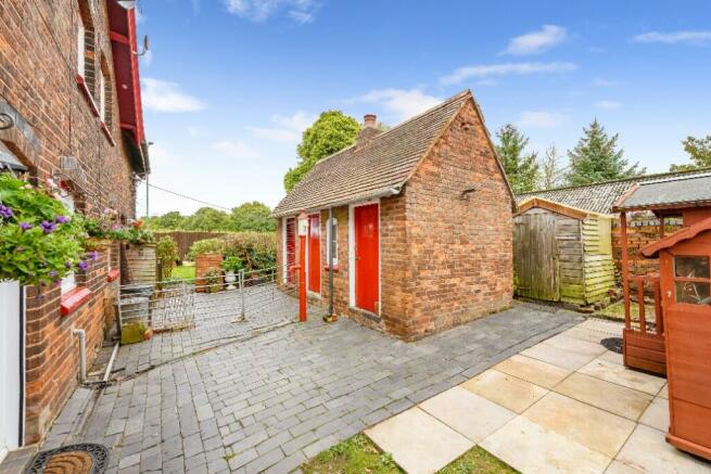
On entering the farmyard, there are traditional brick buildings which subject to obtaining a relevant planning permission could be repurposed for residential or alternative use.
The farmyard is utilised for equipment and fodder storage and for the storage of caravans, an activity which has existed on the site for several decades.
THE LAND
The bulk of the pasture land is accessed through the farmyard or directly off Sutton Road or Crook Lane which divides the farm. The land is generally level and has been down to pasture for many years although a number of the parcels have historically grown arable crops. It is currently primarily utilised for hay and haylage production with some pony grazing close to the farmstead and on the land to the east of Crook Lane.
PROPERTY SCHEDULE
MOAT FARM (acres and hectares)
Cottages and gardens 0.20ac 0.081ha
Stable yard 0.11ac 0.046ha
Farmyard 0.90ac 0.365ha
Old Moat 1.65ac 0.669ha
Pony Paddock 0.23ac 0.095ha
Moat Field 6.15ac 2.489ha
Roadside Paddocks 0.90ac 0.365ha
Hayfield 1 3.72ac 1.504ha
Hayfield 2 3.66ac 1.483ha
SERVICES
The property benefits from mains water and electricity connections while foul drainage is to a septic tank.
COUNCIL TAX
Metropolitan borough of Walsall (Walsall Council)
Moat Farm, 682 Sutton Road - Band A £1583.53 (2024/2025)
Moat Farm, 684 Sutton Road - Band A £1583.53 (2024/2025)
TENURE & POSSESSION
We are advised that the property is freehold and that vacant possession will be available on completion.
EASEMENTS, WAYLEAVES & RIGHTS OF WAY
The property is sold subject to and with the benefit of all existing rights of way whether public or private, light support drainage water and electricity supplies together with all the rights of way obligations easements and wayleaves whether referred to in these particulars or not.
MONEY LAUNDERING REGULATIONS
Within the terms of the Money Laundering Regulations (MLR2017) all potential purchasers making an offer will be required to produce two forms of identity, acceptable examples are a recent utility bill and photographic ID (passport or photographic driving licence).
VIEWING
STRICTLY by prior appointment with the Selling Agents. Viewing days will be arranged as marketing progresses. Anyone visiting to view the property will be required to present photographic proof of identification during the viewing.
METHOD OF SALE
The property is offered for sale by private treaty.
OVERAGE
The property will be sold subject to an overage agreement in the event of any non-agricultural or non-equine development, whereby the owner will require to pay an uplift based on the difference between agricultural/equine value and the value of the land subject to planning permission on commencement of development or sale whichever is sooner. The uplift to be 40% with a period of 50 years.
Brochures
Brochure 1Energy Performance Certificates
EPC 1EPC 2Sutton Road, WS9

NEAREST STATIONS
Distances are straight line measurements from the centre of the postcode- Walsall Station2.7 miles
- Tame Bridge Parkway Station3.0 miles
- Bescot Stadium Station3.2 miles
About Nock Deighton, Agricultural LLP
Old Smithfield, 34-35 Whitburn Street Bridgnorth WV16 4QN
Notes
Disclaimer - Property reference R271farm. The information displayed about this property comprises a property advertisement. Rightmove.co.uk makes no warranty as to the accuracy or completeness of the advertisement or any linked or associated information, and Rightmove has no control over the content. This property advertisement does not constitute property particulars. The information is provided and maintained by Nock Deighton, Agricultural LLP. Please contact the selling agent or developer directly to obtain any information which may be available under the terms of The Energy Performance of Buildings (Certificates and Inspections) (England and Wales) Regulations 2007 or the Home Report if in relation to a residential property in Scotland.
Map data ©OpenStreetMap contributors.