Mill Lane, GU32

- PROPERTY TYPE
Land
- SIZE
315,810 sq ft
29,340 sq m
Key features
- SEE AND PRINT PDF SALES PARTICULARS AVAILABLE BELOW
- SEE DRONE VIDEO FOOTAGE ON THE VIRTUAL TOUR TAB
- APPROX. 7.25 ACRES IN ALL
- PASTURE LAND (4.03 ACRES GRAZEABLE/CROPPABLE)
- ELEVATED POSITION WITH FAR REACHING VIEWS
- SURROUNDED BY WOODLAND AND MATURE CONIFEROUS AND BROADLEAVED TREES
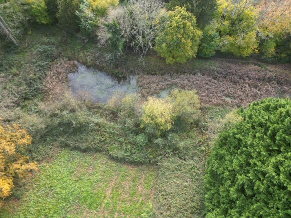
- TWO PONDS (TOTAL 0.6 ACRES) WITH ESTABLISHED AQUATIC PLANTS
- VEHICULAR FRONTAGE/ACCESS
- PUBLIC FOOTPATH WITHIN PERIMETER
- SOUTH DOWNS NATIONAL PARK
Description
VIDEO DRONE FOOTAGE: See the Selling Agent's website for further details, photographs and drone video footage is available showing the whole Property.
LOCATION: See Location Plan where the Property is identified by a red arrow. Postcode GU32 2DJ. Access and Road Frontage - What3Words - Steep Village is positioned immediately to the north of the Town of Petersfield and the Property can be accessed from the town itself or off the A272 or the A32 main roads in the locality. Use the Postcode or What3Words as stated in the 'Location' above.
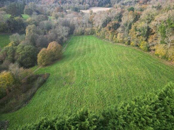
DESCRIPTION: The Property extends in all to approx. 7.25 acres (2.93 Ha) as outlined red on the Site Plan.
The majority of the area is pasture land suitable for grazing or cropping (approx. 4.00 acres) and there are also 2 Ponds (total approx. 0.6 acres according to Ordnance Survey). The remaining area comprises the made up pedestrian path and other areas off grass bank and pockets of woodland (approx. 2.65 acres).
The pasture land occupies an elevated position and from its highest point along the northern boundary the land gently slopes down in a south westerly direction towards the Ponds and the pedestrian path at the bottom of the slope.
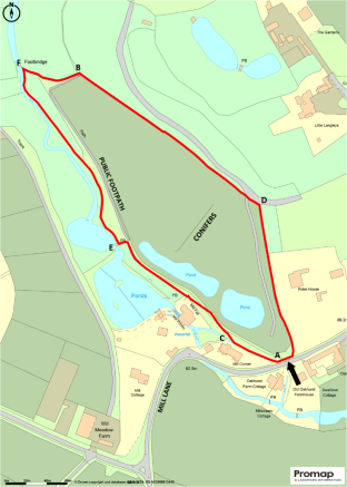
Access off Mill Lane is at the southern end which allows pedestrians to use the route of the Public Footpath between the positions A and B on the Site Plan and the vehicular gate to access the pasture.
The Ponds have been in place for at least 35 years and have established aquatic vegetation species within and attract a variety of birdlife and other wildlife.
PONDS: The Ponds are understood to be fed from run off from adjoining land, there is no stream entering the Ponds, nor leaving it. Approximate depth believed to be approx. 3ft (1m) but this is unchecked. Total Area of both Ponds 0.6 acres (according to Ordnance Survey). There is an island within the pond nearest to Mill Lane.
LAND REGISTRY: The Property forms part of Title HP395656 and copies of both the Title Plan and Register are available on the Selling Agent's website.
PLANNING: The land is zoned a 'Countryside' within the South Downs - Local Plan.
DESIGNATIONS: None affect the Property.
BOUNDARIES: The north western boundary between positions B and D is unfenced and is positioned along the bank which is at the edge of the neighbouring woodland. There is a wooden peg at position D which identifies the corner of the Property.
There is a fence along the position of the boundary between positions E and F.
HISTORIC TRACK: As identified on the Site Plan inside the eastern boundary of the Property, there is the route of a made up vehicular track, which has not been used in recent years and grass has established over it. The stone surface is exposed at certain points. This feature is close to the vehicular entrance off Mill Lane.
PUBLIC FOOTPATH: A Public Footpath route named 'Hangers Way' passes across the Property inside the south western boundary upon the surfaced route as identified on the Site Plan between positions A and B. The route of this Public Footpath also branches off to the west at position C on the Site Plan.
See an extract of the Hampshire County Council Definitive Map gap on the Selling Agent's website on which the Property is highlighted yellow. The route of the Public Footpaths 18 and 36 are shown by purple line just inside the perimeter of the Property.
SERVICES: None connected. Various utilities are available in the locality.
LOCAL AUTHORITY: East Hampshire District Council, (EHDC), Penns Place, Petersfield GU31 4EX.
SOUTH DOWNS NATIONAL PARK AUTHORITY (SDNPA): South Downs Centre, North Street, Midhurst, West Sussex GU29 9DH.
OFFER INSTRUCTIONS: Please see the Additional Document on Selling Agent's website for instructions as to how to make an offer by Private Treaty.
Brochures
Sales ParticularsMill Lane, GU32

NEAREST STATIONS
Distances are straight line measurements from the centre of the postcode- Petersfield Station1.4 miles
- Liss Station2.4 miles
About Giles Wheeler-Bennett, Southampton
West Court, Lower Basingwell Street, Bishop's Waltham, SO32 1AJ
Notes
Disclaimer - Property reference MillLaneSteep. The information displayed about this property comprises a property advertisement. Rightmove.co.uk makes no warranty as to the accuracy or completeness of the advertisement or any linked or associated information, and Rightmove has no control over the content. This property advertisement does not constitute property particulars. The information is provided and maintained by Giles Wheeler-Bennett, Southampton. Please contact the selling agent or developer directly to obtain any information which may be available under the terms of The Energy Performance of Buildings (Certificates and Inspections) (England and Wales) Regulations 2007 or the Home Report if in relation to a residential property in Scotland.
Map data ©OpenStreetMap contributors.