
West Camel, Yeovil, Somerset, BA22
- PROPERTY TYPE
Equestrian Facility
- SIZE
Ask agent
- TENUREDescribes how you own a property. There are different types of tenure - freehold, leasehold, and commonhold.Read more about tenure in our glossary page.
Ask agent
Key features
- Single Residential Development Plot
- Detailed Planning Permission for Detached House
- 3 Month Marketing Restriction
- No Overage Clause
- The Site Extends to Approximately 1.31 Acres (0.53 ha)
- Ideal for Both Self Builders and Developers
Description
LOCATION
The site occupies a substantial plot within the desirable village of West Camel, some 6 miles north east of the town centre of Yeovil. The market town of Sherborne lies approximately 7 miles distant to south east.
West Camel has a small range of amenities including All Saints Church, a Public House (The Walnut Tree), playing fields and a community centre (The Davis Hall).
The neighbouring village of Queen Camel lies approximately 2 miles distant to the east and benefits from a range of facilities and amenities including (but not limited to): St Barnabas Parish Church, Countess Gytha Primary School, Queen Camel Memorial Hall, The Mildmay Arms, and Queen Camel Medical Centre.
COMMUNICATIONS
Road - The A303 is conveniently located just 0.5 miles to the north, providing links to the M5 motorway at Taunton (Junction 25) via the A358 and links to London.
Rail - Yeovil Junction is located approximately 9 miles to the south, Sherborne Railway Station is approximately 8 miles to the south east and Castle Cary Station is approximately 10 miles to the north east. All stations provide mainline services to destinations such as Exeter St David’s, London Paddington and London Waterloo.
Air - Bristol Airport is located approximately 38 miles to the north. It has scheduled and chartered flights to a range of national and international destinations. Exeter Airport is located approximately 46 miles to the south west.
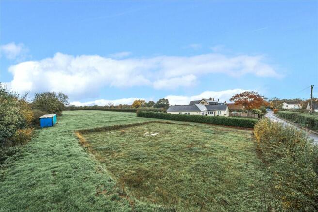
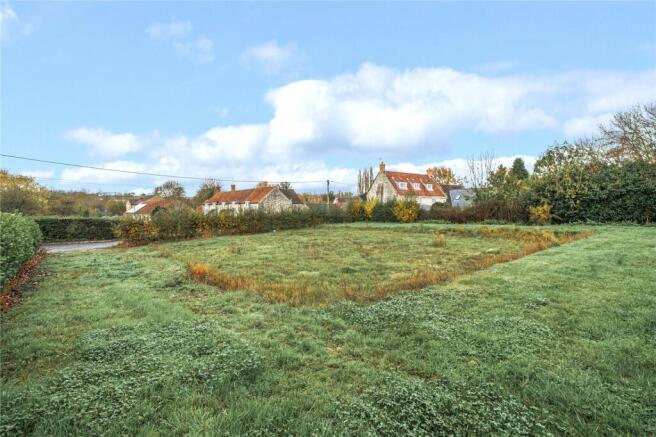
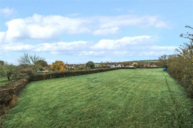
BUILDING PLOT
The building plot is situated off West Street, a well maintained public highway, leading directly into the village. The site adjoins other residential properties to the north, east and west and agricultural land directly to the south.
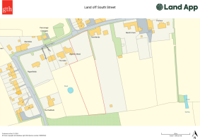
The site benefits from detailed planning permission for the erection of a detached, two storey, four bedroom dwelling. Planning Reference Number: 23/02002/S73A. The plot currently comprises a single enclosure of level pasture land extending, in total, to approximately 1.31 acres (0.53 ha) or thereabouts and is bound by mature hedgerows. The site is shown edged red on the attached site plan. It is shown for identification purposes only and is not to be relied upon.
PROPOSED NEW HOME
The proposed new home will comprise of 1no. Dwelling with a Gross Internal Area (GIA) of approximately 3,986 sq. ft (370.35 sq.m). The dwelling will be of natural stone construction beneath a clay tile roof with three bedrooms to the first floor, all of which are Ensuite. The ground floor will comprise a further bedroom and wet room, open plan kitchen/dining area, living room, conservatory and WC. The property comes with a garden, paddock and parking for three vehicles.
ACCESS
Access is provided via the existing vehicle access from South Street via a gateway.
COMMUNITY INFRASTRUCTURE LEVY
We understand that Community Infrastructure Levy (CIL) will be payable if the proposed new home is built by a housebuilder/developer, but it will not be payable if it is built by a self-builder due to an exemption for self-build schemes.
ADDITIONAL INFORMATION
The property will be subject to an initial marketing restriction for a period of three months to the administrative area of the South Somerset District or anyone who qualifies under section 5.2 as set out in the following criteria:
5.2.1 - The person having a family member who lives in West Camel and has done so for a continuous period of at least five years;
5.2.2 - Being a Person whose upbringing or significant part of their upbringing took place in West Camel;
5.2.3 - Having previously lived in West camel for at least five years and now wishes to return to live in West Camel
This period will end on 30th January 2025. After this, the property will be marketed openly without further restriction.
PHOSPHATES
Planning permission was granted in January 2024 and therefore phosphate mitigation is not required.
SERVICES
We understand that mains drainage, water and electric will be available on or near the plot. Ultrafast Fibre broadband is also available (Wessex Internet).
All interested parties should make their own enquiries with the Statutory Utility Providers.
MOBILE COVERAGE
For an indication of specific speeds and supply or coverage in the area we recommend contacting your own provider.
TENURE AND POSSESSION
The land is of freehold tenure with full vacant possession available upon completion of the purchase.
OVERAGE CLAUSE
There will be NO overage clause attached to the sale.
METHOD OF SALE
We are offering the freehold for sale by private treaty, with vacant possession on completion.
GUIDE PRICE
The guide price is £300,000.
VALUE ADDED TAX
The seller will not opt to tax; therefore, VAT will not be payable in addition to the purchase price.
All interested parties should make their own enquiries with HMRC.
RIGHTS OF WAY, WAYLEAVES AND EASEMENTS
There are no public rights of way. The sale is subject to all rights of support, public and private rights of way, water, light, drainage and other easements, quasi-easements, all or any other like rights, whether mentioned in these particulars or not.
VIEWINGS
The site can be viewed on foot at any reasonable time with a copy of these particulars in hand. Please observe the country code and ensure all gates are closed.
FLOOD ZONE
The property is in an area at a very low risk of flooding from River/Sea and Surface Water (defined as the chance of flooding each year as less than 0.1%).
LOCAL AUTHORITY
Somerset Council
The Council offices, Brympton Way, Yeovil, Somerset, BA20 2HT
W:
T:
DIRECTIONS
Sat Nav: BA22 7QQ
What3Words: ///forgotten.reshaping.mentioned
From Yeovil, head north along Mudford Road (A359) for approximately 6 miles, passing through the villages of Mudford and Marston Magna. Take the first exit at the roundabout, as you enter Queen Camel and follow West camel Road for approximately 1.2 miles. Turn right onto Southmead Lane and continue on this road for approximately 0.2 miles. The gateway to the site is located on the right hand side, as indicated by a GTH for sale board.
Brochures
Particulars- COUNCIL TAXA payment made to your local authority in order to pay for local services like schools, libraries, and refuse collection. The amount you pay depends on the value of the property.Read more about council Tax in our glossary page.
- Band: TBC
- PARKINGDetails of how and where vehicles can be parked, and any associated costs.Read more about parking in our glossary page.
- Yes
- GARDENA property has access to an outdoor space, which could be private or shared.
- Yes
- ACCESSIBILITYHow a property has been adapted to meet the needs of vulnerable or disabled individuals.Read more about accessibility in our glossary page.
- Ask agent
Energy performance certificate - ask agent
West Camel, Yeovil, Somerset, BA22

Add an important place to see how long it'd take to get there from our property listings.
__mins driving to your place
Get an instant, personalised result:
- Show sellers you’re serious
- Secure viewings faster with agents
- No impact on your credit score


Your mortgage
Notes
Staying secure when looking for property
Ensure you're up to date with our latest advice on how to avoid fraud or scams when looking for property online.
Visit our security centre to find out moreDisclaimer - Property reference YEA240066. The information displayed about this property comprises a property advertisement. Rightmove.co.uk makes no warranty as to the accuracy or completeness of the advertisement or any linked or associated information, and Rightmove has no control over the content. This property advertisement does not constitute property particulars. The information is provided and maintained by Greenslade Taylor Hunt, Yeovil. Please contact the selling agent or developer directly to obtain any information which may be available under the terms of The Energy Performance of Buildings (Certificates and Inspections) (England and Wales) Regulations 2007 or the Home Report if in relation to a residential property in Scotland.
*This is the average speed from the provider with the fastest broadband package available at this postcode. The average speed displayed is based on the download speeds of at least 50% of customers at peak time (8pm to 10pm). Fibre/cable services at the postcode are subject to availability and may differ between properties within a postcode. Speeds can be affected by a range of technical and environmental factors. The speed at the property may be lower than that listed above. You can check the estimated speed and confirm availability to a property prior to purchasing on the broadband provider's website. Providers may increase charges. The information is provided and maintained by Decision Technologies Limited. **This is indicative only and based on a 2-person household with multiple devices and simultaneous usage. Broadband performance is affected by multiple factors including number of occupants and devices, simultaneous usage, router range etc. For more information speak to your broadband provider.
Map data ©OpenStreetMap contributors.