Kings Road, Barnetby, Lincolnshire, DN38

- SIZE AVAILABLE
131,987 sq ft
12,262 sq m
- SECTOR
Land for sale
Key features
- Agricultural land
- Suitable for residential development (subject to planning)
- Village location with good transport links
- Overall site approx. 3.03 acres (1.22 ha)
Description
Location
Barnetby Le Wold a rural village on the edge of the Wolds in North Lincolnshire benefits from a primary school, public house with restaurant and hotel, guest house, convenience stores and is well connected to existing pedestrian, cycle, and public transport routes including a main line railway station.
The village is positioned just to the south of 'Barnetby Top' a roundabout junction which provides immediate access to the A15 north, A180 east & M180 west, allowing easy access to Scunthorpe, Grimsby and Kingston upon Hull and the national motorway network.
Barnetby Railway Station is on the Trans Pennine mainline with regular trains direct to Manchester Piccadilly and connections for London King's Cross and the East Coast mainline via Doncaster. There are also regular local bus services.
Humberside International Airport is only approx. 4 miles away from Barnetby Le Wold and operates daily services to Amsterdam and Aberdeen plus various holiday destinations.
Description
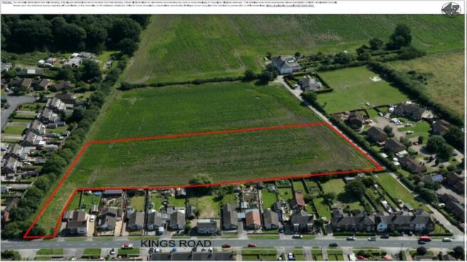
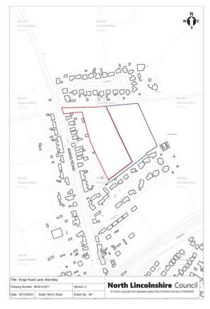
The land in agricultural use is relatively flat and extends to approximately approx. 3.03 acres (1.22 ha), edged red on the Location Plan.
The site is in a well established residential area to the east of residential properties on Kings Road and cul-de-sac developments to the north and south, with open fields and woodlands beyond to the east.
Development
The seller would welcome proposals from developers for the development of retirement housing/older person's accommodation.
Planning
Prospective purchasers are strongly recommended to satisfy themselves on all planning matters.
For further information regarding planning matters please contact North Lincolnshire Council's Strategic Housing Team.
Highways
The site is to the east of Kings Road, an adopted highway, with part of the site having direct
frontage on to Kings Road.
Highway access to the site can be gained from Kings Road. Vehicle access points will need to be agreed by the Local Highways Authority. This site has good access to local services and facilities and is well connected to existing pedestrian, cycle, and public transport routes.
A covenant of the contract of sale would include a provision that would require the purchaser and their successors in title to create and maintain a roadway to a highway adoptable standard, size, and location to be agreed, for the benefit of the council's retained land, outlined blue on the Location Plan.
Please contact North Lincolnshire Council's Highway Development Services to discuss access to the Site or other issues.
Brochures
Kings Road, Barnetby, Lincolnshire, DN38

NEAREST STATIONS
Distances are straight line measurements from the centre of the postcode- Barnetby Station0.3 miles
- Brigg Station3.8 miles
- Ulceby Station5.2 miles
About North Lincolnshire Council, Scunthorpe
Church Square House, 30-40 High Street, Scunthorpe, North Lincolnshire, DN15 6NLNotes
Disclaimer - Property reference KingsRoad. The information displayed about this property comprises a property advertisement. Rightmove.co.uk makes no warranty as to the accuracy or completeness of the advertisement or any linked or associated information, and Rightmove has no control over the content. This property advertisement does not constitute property particulars. The information is provided and maintained by North Lincolnshire Council, Scunthorpe. Please contact the selling agent or developer directly to obtain any information which may be available under the terms of The Energy Performance of Buildings (Certificates and Inspections) (England and Wales) Regulations 2007 or the Home Report if in relation to a residential property in Scotland.
Map data ©OpenStreetMap contributors.