

Nowton, Bury St Edmunds, Suffolk, IP29

- PROPERTY TYPE
Land
- SIZE
83,200 sq ft
7,730 sq m
Description
Location
Nowton is a small village located approximately 3 miles south of the market town of Bury St Edmunds which offers a wide range of services and amenities.
The Land
The farmland is classified as Grade 2 on the MAFF Land Classification Maps.
Description
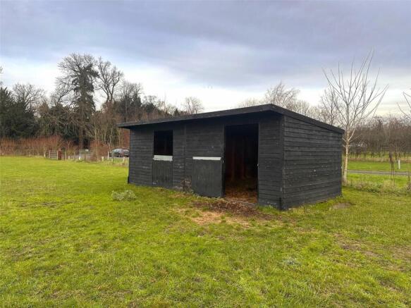
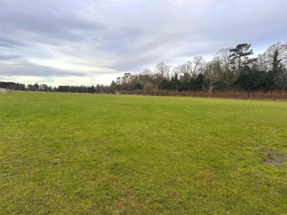
The land extends to 1.91 acres (0.77 hectares), comprising of grassland with a single field shelter, currently used for the grazing of livestock. The land is accessible via a right of way over an existing driveway off Bury Road as outlined in green on the attached plan (for illustrative purposes only). To the boundaries of the land is stock fencing.
Tenure and Possession
The land is farmed in hand and offered with vacant possession.
Minerals, Timber and Sporting Rights
These rights are in hand and included within the sale.
Environmental Schemes
We have not been made aware of any Environmental Schemes relating to the land parcel.
Rights of Way, Easements and Wayleaves
The property is sold and conveyed with the benefit and subject to all rights of way (whether public or private), water, drainage, sewerage, light, wayleaves and other easements, if any, subject to all outgoing and charges connected with or chargeable upon the property whether mentioned herein or not.
Local Authorities
West Suffolk District Council: West Suffolk House, Western Way, Bury St Edmunds, Suffolk, IP33 3YU. Suffolk County Council: Endeavour House, 8 Russel Road, Ipswich, Suffolk, IP1 2BX. Anglian Water Services Ltd: PO Box 46, Spalding, Lincs, PE11 1DB. Environment Agency: Cobham Road, Ipswich, Suffolk, IP1 1JE.
Method of Sale
The land is sold as a whole via private treaty. Interested parties should register their interest with the Agent’s Bury St Edmunds office providing full details including their postal address, telephone numbers and email address (if appropriate).
Restrictive Covenant
The property will be subject to a restrictive covenant on the access way allowing the right of way to only be used for agricultural purposes and on the land stating that it must only be used for paddock land or for agricultural purposes and it cannot be used for pigs.
VAT
In addition to the purchase price, should any sale of the property or any right attached to it become chargeable supply for the purpose of Value Added Tax, such shall be payable by the Purchaser(s) in addition to monies to be paid during the course of the sale and the purchaser shall indemnify the Vendors in respect thereof, including interest or penalty payments. No election has been made to charge VAT on property sales.
Anti-Money Laundering
In accordance with the most recent Anti-Money Laundering Legislation, Purchaser(s) will be required to provide proof of identity to vendors’ agents once an offer is submitted and prior to solicitors being instructed.
Postcode
The nearest postcode is IP29 5ND.
What3Words
galloping.changing.indirect
Viewing
Strictly by appointment with the agents at the Bury St Edmunds office and during daylight hours. Please contact Graham Ford or Eleanor Pratt.
Brochures
ParticularsNowton, Bury St Edmunds, Suffolk, IP29

NEAREST STATIONS
Distances are straight line measurements from the centre of the postcode- Bury St. Edmunds Station2.7 miles
- Thurston Station3.6 miles

About Lacy Scott & Knight, Bury St Edmunds
10 Risbygate Street Bury St. Edmunds IP33 3AA


Notes
Disclaimer - Property reference BAL240018. The information displayed about this property comprises a property advertisement. Rightmove.co.uk makes no warranty as to the accuracy or completeness of the advertisement or any linked or associated information, and Rightmove has no control over the content. This property advertisement does not constitute property particulars. The information is provided and maintained by Lacy Scott & Knight, Bury St Edmunds. Please contact the selling agent or developer directly to obtain any information which may be available under the terms of The Energy Performance of Buildings (Certificates and Inspections) (England and Wales) Regulations 2007 or the Home Report if in relation to a residential property in Scotland.
Map data ©OpenStreetMap contributors.