Land for sale
Hunton Road, DL9

- SIZE
Ask agent
- SECTOR
Land for sale

Key features
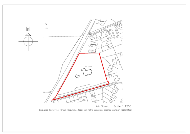
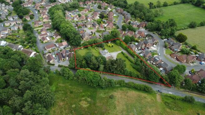
- Attractive and rarely available residential development opportunity extending to 0.48 ha (1.19 acres)
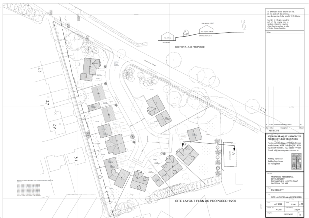
- Outline planning permission granted for ten dwellings
- Convenient and attractive North Yorkshire village location
- Full suite of technical information available.
Description
Extending to approximately 1.19 acre (0.48ha), the opportunity consists of an existing bungalow set in extensive, mature grounds, bound by residential dwellings to the north, east and south and Hunton Road to the west (with open fields beyond). The land is generally flat, but falls steeply to the northern boundary. Mature trees and shrubbery follow the majority of the boundaries, with the exception of a section along the northern boundary offering far reaching views northwards.
Access is from Hunton Road, currently at the corner of the western and southern boundaries. The approved access forming part of the outline planning permission is moved a few metres north to facilitate 90m visibility splays.
The site is located to the south west of Scotton, an attractive village approximately 1km south of Catterick Garrison. The Garrison benefits from a wide range of local facilities and services including supermarkets and leisure venues, and work has just started on a £19 Million upgrade to its Town Centre. This will provide a new Town Square, a Community & Enterprise building and improvements to Coronation Park (new play equipment and a Sensory Garden) and cycle and footpaths. In addition, the construction of the new Catterick Integrated Care Campus, providing enhanced health and care services is now well underway and is expected to be operational in 2026. The towns of Leyburn, Bedale and Richmond all lie within a 6km radius, with the boundary of the Yorkshire Dales National Park being located approximately 8km from the site. Access to the A1 is conveniently situated at the Catterick Interchange some 5km east of the village.
TOWN PLANNING
Outline planning permission for ten dwellings (TP ref: 22/00560/OUT) was granted in October 2023. The site benefitted from a previous Outline planning permission for ten dwellings granted in November 2008 (TP ref: 08/00838/OUT).
A Tree Preservation Order protects some of the trees on site as identified in the Tree Report included as part of the recent Outline planning application.
The land is located within Flood Zone 1.
FURTHER INFORMATION
All the information below can be provided by contacting the selling agents:
All Planning Documents and Drawings
Topographical Survey
CCTV Drainage Survey and Drainage Strategy
Tree Condition Report
Preliminary Ecological Appraisal
VIEWINGS
All viewings will be strictly by prior appointment only. UNDER NO CIRCUMSTNACES SHOULD INTERESTED PARTIES ENTER THE SITE WITHOUT PERMISSION FROM THE SELLING AGENTS. Contact the selling agents to make the necessary arrangements.
TENDER PROCESS
The freehold is offered For Sale via Private Treaty. Offers are to be made in writing, and received at the Harrogate office of the sole selling agents.
Brochures
Hunton Road, DL9

NEAREST STATIONS
Distances are straight line measurements from the centre of the postcode- Leyburn Station5.5 miles
- Bedale Station6.7 miles
About Titchmarsh & Bagley, Harrogate
3rd Floor (NW), The Exchange, Station Parade, Harrogate, HG1 1TSNotes
Disclaimer - Property reference MBScotton. The information displayed about this property comprises a property advertisement. Rightmove.co.uk makes no warranty as to the accuracy or completeness of the advertisement or any linked or associated information, and Rightmove has no control over the content. This property advertisement does not constitute property particulars. The information is provided and maintained by Titchmarsh & Bagley, Harrogate. Please contact the selling agent or developer directly to obtain any information which may be available under the terms of The Energy Performance of Buildings (Certificates and Inspections) (England and Wales) Regulations 2007 or the Home Report if in relation to a residential property in Scotland.
Map data ©OpenStreetMap contributors.